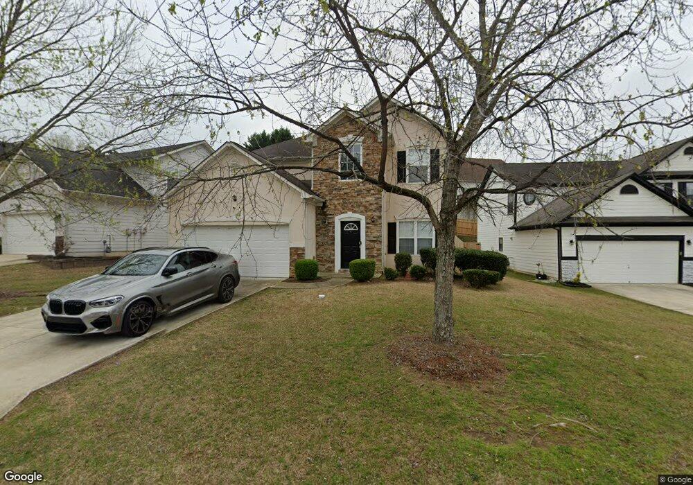
7710 Parkside Dr Unit 1 Lithia Springs, GA 30122
Lithia Springs NeighborhoodEstimated Value: $315,079 - $352,000
4
Beds
3
Baths
2,010
Sq Ft
$165/Sq Ft
Est. Value
About This Home
This home is located at 7710 Parkside Dr Unit 1, Lithia Springs, GA 30122 and is currently estimated at $332,270, approximately $165 per square foot. 7710 Parkside Dr Unit 1 is a home located in Douglas County with nearby schools including Sweetwater Elementary School, Factory Shoals Middle School, and New Manchester High School.
Ownership History
Date
Name
Owned For
Owner Type
Purchase Details
Closed on
Aug 1, 2017
Sold by
Kyei Cecil
Bought by
Wilmington Savings Fund Societ
Current Estimated Value
Purchase Details
Closed on
Apr 28, 2003
Sold by
Ryland Group Inc
Bought by
Kyei Cecil
Home Financials for this Owner
Home Financials are based on the most recent Mortgage that was taken out on this home.
Original Mortgage
$171,941
Interest Rate
5.86%
Mortgage Type
FHA
Create a Home Valuation Report for This Property
The Home Valuation Report is an in-depth analysis detailing your home's value as well as a comparison with similar homes in the area
Home Values in the Area
Average Home Value in this Area
Purchase History
| Date | Buyer | Sale Price | Title Company |
|---|---|---|---|
| Wilmington Savings Fund Societ | -- | -- | |
| Kyei Cecil | $173,400 | -- |
Source: Public Records
Mortgage History
| Date | Status | Borrower | Loan Amount |
|---|---|---|---|
| Previous Owner | Kyei Cecil | $171,941 |
Source: Public Records
Tax History Compared to Growth
Tax History
| Year | Tax Paid | Tax Assessment Tax Assessment Total Assessment is a certain percentage of the fair market value that is determined by local assessors to be the total taxable value of land and additions on the property. | Land | Improvement |
|---|---|---|---|---|
| 2024 | $4,539 | $128,480 | $26,120 | $102,360 |
| 2023 | $4,539 | $128,480 | $26,120 | $102,360 |
| 2022 | $4,342 | $107,040 | $18,000 | $89,040 |
| 2021 | $3,248 | $79,760 | $14,160 | $65,600 |
| 2020 | $2,813 | $79,760 | $14,160 | $65,600 |
| 2019 | $2,952 | $77,200 | $14,160 | $63,040 |
| 2018 | $2,648 | $66,920 | $12,920 | $54,000 |
| 2017 | $2,339 | $61,120 | $13,080 | $48,040 |
| 2016 | $2,166 | $55,840 | $12,600 | $43,240 |
| 2015 | $2,030 | $51,080 | $11,840 | $39,240 |
| 2014 | $1,848 | $47,760 | $11,840 | $35,920 |
| 2013 | -- | $43,440 | $10,920 | $32,520 |
Source: Public Records
Map
Nearby Homes
- 7621 Forest Glen Way Unit 2
- 1657 Bradmere Ln
- 1920 Rock House Rd
- 1657 Karsyn Ln
- 1682 Walton Reserve Blvd
- 1736 Walton Reserve Way
- 7147 Walton Reserve Ln
- 7368 Mount Vernon Rd
- 973 Forest Knoll Ct
- 2790 Deerfield Dr
- 00 Six Flags Rd
- 859 Aspen Dr
- 7306 Mount Vernon Rd
- 0 Rock House Rd Unit 10135378
- 00 Rock House Rd
- 6854 Panda Ct Unit A
- 6810 Panda Dr Unit B
- 6811 Panda Dr Unit A
- 1395 Ling Dr Unit 2
- 1311 Park Center Cir
- 7708 Parkside Dr
- 7712 Parkside Dr
- 7714 Parkside Dr
- 1605 Bradmere Ln
- 7706 Parkside Dr Unit 1
- 1603 Bradmere Ln
- 7716 Parkside Dr Unit 1
- 1607 Bradmere Ln Unit 2
- 7711 Parkside Dr
- 7709 Parkside Dr
- 7704 Parkside Dr Unit 1
- 7713 Parkside Dr Unit 1
- 7707 Parkside Dr
- 1609 Bradmere Ln
- 7715 Parkside Dr
- 1601 Bradmere Ln Unit 2
- 7718 Parkside Dr
- 7705 Parkside Dr
- 7702 Parkside Dr
- 1611 Bradmere Ln