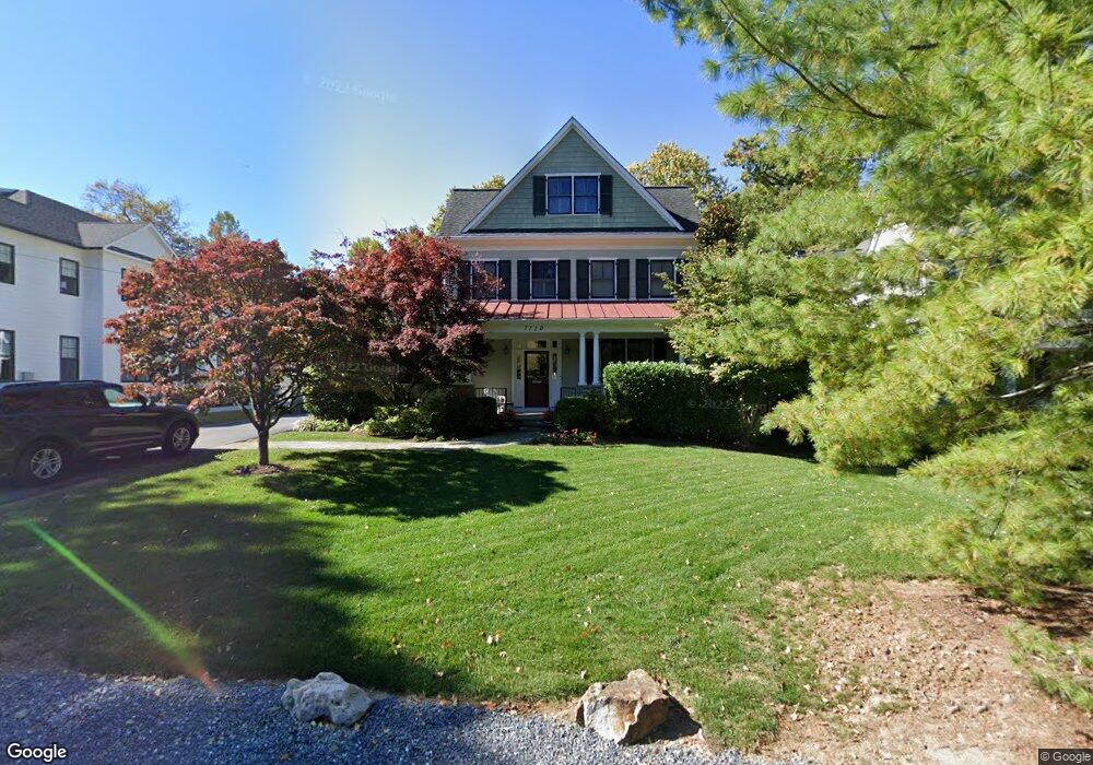
7710 Radnor Rd Bethesda, MD 20817
Kenwood Park NeighborhoodEstimated Value: $1,955,183 - $2,608,000
--
Bed
5
Baths
3,221
Sq Ft
$725/Sq Ft
Est. Value
About This Home
This home is located at 7710 Radnor Rd, Bethesda, MD 20817 and is currently estimated at $2,336,546, approximately $725 per square foot. 7710 Radnor Rd is a home located in Montgomery County with nearby schools including Bradley Hills Elementary School, Thomas W. Pyle Middle School, and Walt Whitman High School.
Ownership History
Date
Name
Owned For
Owner Type
Purchase Details
Closed on
Nov 24, 2004
Sold by
Banks Development Llc
Bought by
Hollensteiner Malcolm B and Hollensteiner Carey S
Current Estimated Value
Purchase Details
Closed on
Oct 22, 2004
Sold by
Banks Developmemt Llc
Bought by
Banks Development Llc
Purchase Details
Closed on
May 12, 2003
Sold by
Thomas Linda S
Bought by
Banks Development Llc
Create a Home Valuation Report for This Property
The Home Valuation Report is an in-depth analysis detailing your home's value as well as a comparison with similar homes in the area
Home Values in the Area
Average Home Value in this Area
Purchase History
| Date | Buyer | Sale Price | Title Company |
|---|---|---|---|
| Hollensteiner Malcolm B | $1,725,000 | -- | |
| Hollensteiner Malcolm B | $1,725,000 | -- | |
| Banks Development Llc | -- | -- | |
| Banks Development Llc | $1,100,000 | -- |
Source: Public Records
Tax History Compared to Growth
Tax History
| Year | Tax Paid | Tax Assessment Tax Assessment Total Assessment is a certain percentage of the fair market value that is determined by local assessors to be the total taxable value of land and additions on the property. | Land | Improvement |
|---|---|---|---|---|
| 2025 | $17,690 | $1,647,000 | -- | -- |
| 2024 | $17,690 | $1,461,300 | $719,100 | $742,200 |
| 2023 | $16,846 | $1,450,167 | $0 | $0 |
| 2022 | $15,961 | $1,439,033 | $0 | $0 |
| 2021 | $15,722 | $1,427,900 | $684,800 | $743,100 |
| 2020 | $18,067 | $1,427,900 | $684,800 | $743,100 |
| 2019 | $15,678 | $1,427,900 | $684,800 | $743,100 |
| 2018 | $7,464 | $1,481,900 | $652,200 | $829,700 |
| 2017 | $8,782 | $1,436,667 | $0 | $0 |
| 2016 | $13,963 | $1,391,433 | $0 | $0 |
| 2015 | $13,963 | $1,346,200 | $0 | $0 |
| 2014 | $13,963 | $1,339,800 | $0 | $0 |
Source: Public Records
Map
Nearby Homes
- 7505 Marbury Rd
- 8013 Aberdeen Rd
- 6108 Landon Ln
- 5707 Northfield Rd
- 6210 Landon Ln
- 7805 Moorland Ln
- 7800 Marion Ln
- 5517 Huntington Pkwy
- 6921 Granby St
- 5420 Moorland Ln
- 5610 Glenwood Rd
- 8501 Rayburn Rd
- 6224 Goodview St
- 5408 Moorland Ln
- 6005 Roosevelt St
- 5700 Tanglewood Dr
- 5507 Charlcote Rd
- 5519 Northfield Rd
- 5605 Glenwood Rd
- 7704 Geranium St
- 7712 Radnor Rd
- 7714 Radnor Rd
- 7713 Oldchester Rd
- 7711 Oldchester Rd
- 7715 Oldchester Rd
- 7709 Oldchester Rd
- 7713 Radnor Rd
- 7706 Radnor Rd
- 7716 Radnor Rd
- 7711 Radnor Rd
- 7717 Radnor Rd
- 7717 Oldchester Rd
- 5720 Wilson Ln
- 7707 Oldchester Rd
- 5718 Wilson Ln
- 7704 Radnor Rd
- 7709 Radnor Rd
- 7719 Oldchester Rd
- 5716 Wilson Ln
- 7705 Oldchester Rd