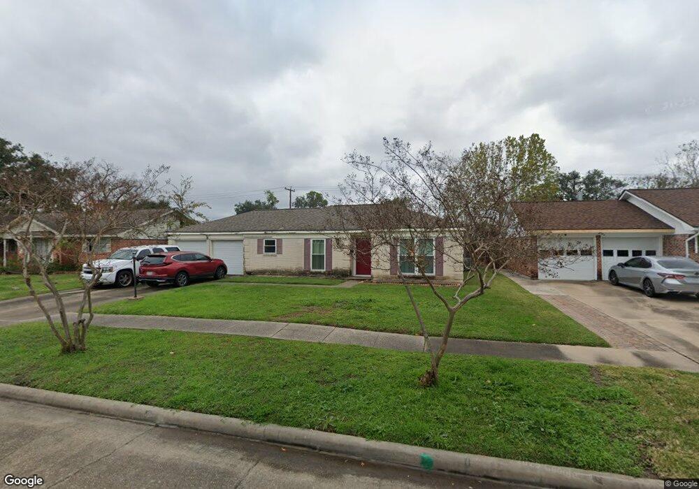
7714 Leader St Houston, TX 77036
Sharpstown NeighborhoodEstimated Value: $292,000 - $310,000
4
Beds
2
Baths
1,861
Sq Ft
$160/Sq Ft
Est. Value
About This Home
This home is located at 7714 Leader St, Houston, TX 77036 and is currently estimated at $298,116, approximately $160 per square foot. 7714 Leader St is a home located in Harris County with nearby schools including Neff Elementary School, Sugar Grove Academy, and Sharpstown High School.
Ownership History
Date
Name
Owned For
Owner Type
Purchase Details
Closed on
Jul 27, 1995
Sold by
Broaddus Howard T and Broaddus Alice B
Bought by
Colah Aspi J and Colah Persis A
Current Estimated Value
Home Financials for this Owner
Home Financials are based on the most recent Mortgage that was taken out on this home.
Original Mortgage
$56,000
Interest Rate
7.49%
Create a Home Valuation Report for This Property
The Home Valuation Report is an in-depth analysis detailing your home's value as well as a comparison with similar homes in the area
Home Values in the Area
Average Home Value in this Area
Purchase History
| Date | Buyer | Sale Price | Title Company |
|---|---|---|---|
| Colah Aspi J | -- | Texas American Title Company |
Source: Public Records
Mortgage History
| Date | Status | Borrower | Loan Amount |
|---|---|---|---|
| Closed | Colah Aspi J | $56,000 |
Source: Public Records
Tax History Compared to Growth
Tax History
| Year | Tax Paid | Tax Assessment Tax Assessment Total Assessment is a certain percentage of the fair market value that is determined by local assessors to be the total taxable value of land and additions on the property. | Land | Improvement |
|---|---|---|---|---|
| 2025 | $3,478 | $278,558 | $135,893 | $142,665 |
| 2024 | $3,478 | $262,937 | $98,145 | $164,792 |
| 2023 | $3,478 | $266,514 | $98,145 | $168,369 |
| 2022 | $4,888 | $235,512 | $60,397 | $175,115 |
| 2021 | $4,539 | $194,751 | $60,397 | $134,354 |
| 2020 | $4,970 | $198,682 | $60,397 | $138,285 |
| 2019 | $5,061 | $193,893 | $45,298 | $148,595 |
| 2018 | $3,447 | $188,915 | $45,298 | $143,617 |
| 2017 | $4,369 | $184,524 | $45,298 | $139,226 |
| 2016 | $3,972 | $179,840 | $45,298 | $134,542 |
| 2015 | $2,422 | $158,955 | $45,298 | $113,657 |
| 2014 | $2,422 | $138,637 | $45,298 | $93,339 |
Source: Public Records
Map
Nearby Homes
- 7819 Bellaire Blvd
- 7419 Barberton Dr
- 8019 Sharpview Dr
- 6403 Fondren Rd Unit D25
- 6602 Harbor Town Dr Unit 1207
- 6602 Harbor Town Dr Unit 1202
- 6500 Harbor Town Dr Unit 3208
- 6500 Harbor Town Dr Unit 2808
- 6500 Harbor Town Dr Unit 3204
- 6500 Harbor Town Dr Unit 3408
- 6500 Harbor Town Dr Unit 2902
- 8314 Edgemoor Dr
- 8223 Golf Green Cir
- 7655 Bellerive Dr Unit 3
- 7520 Hornwood Dr Unit 205
- 7520 Hornwood Dr Unit 1204
- 7520 Hornwood Dr
- 7520 Hornwood Dr Unit 1003
- 7520 Hornwood Dr Unit 1406
- 7210 Leader St
- 7710 Leader St
- 7718 Leader St
- 7706 Leader St
- 7719 Bellaire Blvd
- 7802 Leader St
- 7723 Bellaire Blvd
- 7715 Bellaire Blvd
- 7711 Leader St
- 7727 Bellaire Blvd
- 7715 Leader St
- 7707 Leader St
- 7806 Leader St
- 7803 Leader St
- 7702 Leader St
- 7711 Bellaire Blvd
- 7803 Bellaire Blvd
- 7810 Leader St
- 7003 Lugary Dr
- 7807 Leader St
- 7010 Lugary Dr