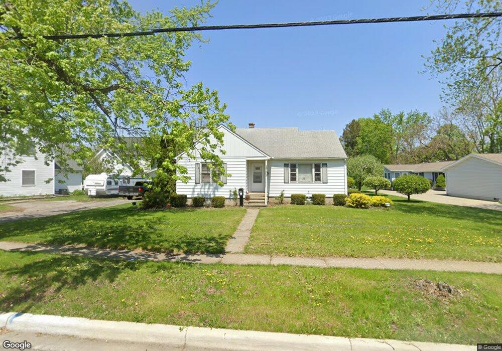
772 W Maple Ave Adrian, MI 49221
Estimated Value: $175,000 - $196,000
4
Beds
1
Bath
1,617
Sq Ft
$113/Sq Ft
Est. Value
About This Home
This home is located at 772 W Maple Ave, Adrian, MI 49221 and is currently estimated at $183,519, approximately $113 per square foot. 772 W Maple Ave is a home located in Lenawee County with nearby schools including Adrian High School, Berean Baptist Academy, and Trenton Hills Learning Center.
Ownership History
Date
Name
Owned For
Owner Type
Purchase Details
Closed on
Feb 21, 2020
Sold by
Max G & T E Soto Ret
Bought by
Ruiz Jesus and Ruiz Angelita
Current Estimated Value
Purchase Details
Closed on
Jan 19, 2011
Sold by
Robin Lublin Suarez Serrano Llc
Bought by
Soto Max G and Theresa E Soto Trust
Purchase Details
Closed on
May 18, 2010
Sold by
Citimortgage Inc
Bought by
Department Of Veterans Affairs
Purchase Details
Closed on
May 6, 2010
Sold by
Wilcox Garry A and Wilcox Kirsten D
Bought by
Citimortgage Inc
Create a Home Valuation Report for This Property
The Home Valuation Report is an in-depth analysis detailing your home's value as well as a comparison with similar homes in the area
Home Values in the Area
Average Home Value in this Area
Purchase History
| Date | Buyer | Sale Price | Title Company |
|---|---|---|---|
| Ruiz Jesus | -- | None Available | |
| Soto Max G | $41,600 | None Available | |
| Department Of Veterans Affairs | -- | None Available | |
| Citimortgage Inc | $50,737 | None Available |
Source: Public Records
Tax History
| Year | Tax Paid | Tax Assessment Tax Assessment Total Assessment is a certain percentage of the fair market value that is determined by local assessors to be the total taxable value of land and additions on the property. | Land | Improvement |
|---|---|---|---|---|
| 2025 | $2,604 | $80,500 | $0 | $0 |
| 2024 | $22 | $80,900 | $0 | $0 |
| 2023 | $2,801 | $72,500 | $0 | $0 |
| 2022 | $4,223 | $64,500 | $0 | $0 |
| 2021 | $2,203 | $59,900 | $0 | $0 |
| 2020 | $2,125 | $54,400 | $0 | $0 |
| 2019 | $1,710 | $53,000 | $0 | $0 |
| 2018 | $2,055 | $64,091 | $0 | $0 |
| 2017 | $1,989 | $52,800 | $0 | $0 |
| 2016 | $1,974 | $51,571 | $0 | $0 |
| 2014 | -- | $44,900 | $0 | $0 |
Source: Public Records
Map
Nearby Homes
- 349 Greenly St
- 333 Greenly St
- 306 Summer St
- 227 Greenly St
- 218 Greenly St
- 914 W Maumee St
- 140 Greenly St
- 959 W Maumee St Unit B
- 143 Park St
- 965 W Maumee St Unit A
- 967 W Maumee St Unit A
- 169 Park St
- 778 College Ave
- 155 S Scott St
- 705 College Ave
- 710 Lakeshire Trail Unit 201E
- 228 W Church St
- 313 Rice St
- 1100 Country Club Rd Unit 1100 blk Country Clu
- 1275 University Ave
- 768 W Maple Ave
- 784 W Maple Ave
- 784 W Maple Ave
- 784 W Maple Ave
- 784 W Maple Ave
- 784 W Maple Ave
- 784 W Maple Ave
- 784 W Maple Ave
- 784 W Maple Ave
- 784 W Maple Ave Unit H
- 784 W Maple Ave Unit G
- 427 Stockford Dr
- 764 W Maple Ave
- 775 W Maple Ave
- 771 W Maple Ave
- 779 Harkness Dr
- 762 W Maple Ave
- 773 Harkness Dr
- 435 Stockford Dr
- 750 W Maple Ave
Your Personal Tour Guide
Ask me questions while you tour the home.