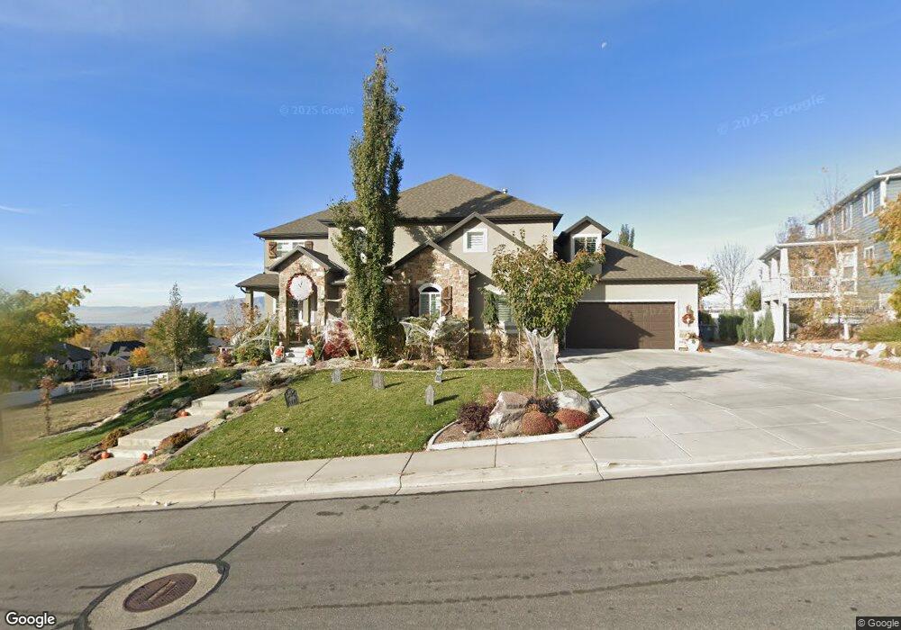
773 N 650 E Unit 2 Lindon, UT 84042
Estimated Value: $751,000 - $1,004,000
4
Beds
3
Baths
3,366
Sq Ft
$277/Sq Ft
Est. Value
About This Home
This home is located at 773 N 650 E Unit 2, Lindon, UT 84042 and is currently estimated at $933,595, approximately $277 per square foot. 773 N 650 E Unit 2 is a home located in Utah County with nearby schools including Lindon Elementary School, Oak Canyon Junior High School, and Pleasant Grove High School.
Ownership History
Date
Name
Owned For
Owner Type
Purchase Details
Closed on
Sep 26, 2025
Sold by
Chiang Xiao Rong
Bought by
Xr & R Family Trust and Chiang
Current Estimated Value
Purchase Details
Closed on
Feb 11, 2021
Sold by
Chiang Xiao Rong and Chiang Rachelle
Bought by
Chiang Xiao Rong
Home Financials for this Owner
Home Financials are based on the most recent Mortgage that was taken out on this home.
Original Mortgage
$226,500
Interest Rate
2.6%
Mortgage Type
New Conventional
Purchase Details
Closed on
Sep 29, 2015
Sold by
Chiang Xiao Rong and Chiang Rachelle A
Bought by
Chiang Xiao Rong and Chiang Rachelle
Home Financials for this Owner
Home Financials are based on the most recent Mortgage that was taken out on this home.
Original Mortgage
$283,000
Interest Rate
2.87%
Mortgage Type
Construction
Purchase Details
Closed on
Dec 20, 2013
Sold by
Commonwealth Land Title Insurance Co
Bought by
Chiang Xiao Rong and Chiang Rachelle A
Purchase Details
Closed on
Apr 6, 2007
Sold by
Metcalf Gary M
Bought by
Commonwealth Land Title Insurance Co
Purchase Details
Closed on
Dec 16, 2005
Sold by
Louder Portia
Bought by
Metcalf Gary M
Home Financials for this Owner
Home Financials are based on the most recent Mortgage that was taken out on this home.
Original Mortgage
$562,000
Interest Rate
6.35%
Mortgage Type
Purchase Money Mortgage
Purchase Details
Closed on
Nov 18, 2005
Sold by
Sumbot Russell
Bought by
Louder Portia
Home Financials for this Owner
Home Financials are based on the most recent Mortgage that was taken out on this home.
Original Mortgage
$562,000
Interest Rate
6.35%
Mortgage Type
Purchase Money Mortgage
Purchase Details
Closed on
Mar 18, 2005
Sold by
H5 Development Lc
Bought by
Sumbot Russell
Home Financials for this Owner
Home Financials are based on the most recent Mortgage that was taken out on this home.
Original Mortgage
$126,000
Interest Rate
5.61%
Mortgage Type
Purchase Money Mortgage
Create a Home Valuation Report for This Property
The Home Valuation Report is an in-depth analysis detailing your home's value as well as a comparison with similar homes in the area
Home Values in the Area
Average Home Value in this Area
Purchase History
| Date | Buyer | Sale Price | Title Company |
|---|---|---|---|
| Xr & R Family Trust | -- | None Listed On Document | |
| Chiang Xiao Rong | -- | Eagle Gate Title Ins Agency | |
| Chiang Xiao Rong | -- | North American Title | |
| Chiang Xiao Rong | -- | Fonders Title Co | |
| Commonwealth Land Title Insurance Co | -- | Meridian Title Company | |
| Metcalf Gary M | -- | Meridian Title Company | |
| Louder Portia | -- | Signature Title Insurance A | |
| Sumbot Russell | -- | Title West Title Company |
Source: Public Records
Mortgage History
| Date | Status | Borrower | Loan Amount |
|---|---|---|---|
| Previous Owner | Chiang Xiao Rong | $226,500 | |
| Previous Owner | Chiang Xiao Rong | $283,000 | |
| Previous Owner | Metcalf Gary M | $562,000 | |
| Previous Owner | Sumbot Russell | $126,000 |
Source: Public Records
Tax History
| Year | Tax Paid | Tax Assessment Tax Assessment Total Assessment is a certain percentage of the fair market value that is determined by local assessors to be the total taxable value of land and additions on the property. | Land | Improvement |
|---|---|---|---|---|
| 2025 | $3,697 | $888,000 | $286,800 | $601,200 |
| 2024 | $3,697 | $455,730 | $0 | $0 |
| 2023 | $3,506 | $464,200 | $0 | $0 |
| 2022 | $3,410 | $436,150 | $0 | $0 |
| 2021 | $3,294 | $635,300 | $223,900 | $411,400 |
| 2020 | $3,155 | $599,100 | $203,500 | $395,600 |
| 2019 | $2,944 | $583,200 | $187,600 | $395,600 |
| 2018 | $2,905 | $542,500 | $171,600 | $370,900 |
| 2017 | $2,692 | $269,555 | $0 | $0 |
| 2016 | -- | $221,045 | $0 | $0 |
| 2015 | $1,800 | $157,600 | $0 | $0 |
| 2014 | $1,528 | $143,700 | $0 | $0 |
Source: Public Records
Map
Nearby Homes
- 787 N 650 E
- 787 N 650 E Unit 1
- 1886 Murdock
- 1844 Murdock
- 668 E 770 N Unit 39
- 668 E 770 N
- 663 E 770 N Unit 40
- 663 E 770 N
- 639 E 720 N
- 682 E 770 N Unit 39
- 682 E 770 N
- 677 E 770 N Unit 38
- 1705 E Murdock Dr
- 633 E 720 N
- 732 N 650 E Unit 15
- 732 N 650 E
- 1695 E 1000 S
- 1695 E Murdock Dr
- 689 E 770 N
- 702 E 770 N Unit 35
Your Personal Tour Guide
Ask me questions while you tour the home.