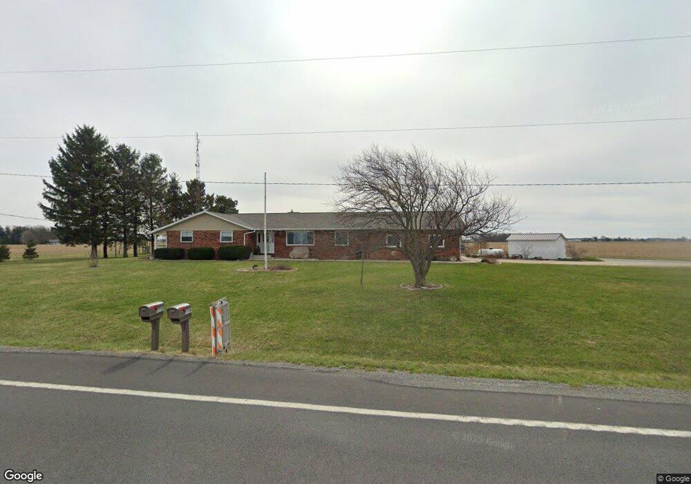
7739 State Route 12 Columbus Grove, OH 45830
Estimated Value: $267,503 - $350,000
3
Beds
3
Baths
1,829
Sq Ft
$163/Sq Ft
Est. Value
About This Home
This home is located at 7739 State Route 12, Columbus Grove, OH 45830 and is currently estimated at $297,626, approximately $162 per square foot. 7739 State Route 12 is a home located in Putnam County with nearby schools including Columbus Grove Elementary School, Columbus Grove Middle School, and Columbus Grove High School.
Ownership History
Date
Name
Owned For
Owner Type
Purchase Details
Closed on
Aug 26, 2024
Sold by
Rader Philip W and Rader Mary L
Bought by
Philip And Mary Rader Irrevocable Trust and Rader
Current Estimated Value
Purchase Details
Closed on
Apr 15, 2016
Sold by
Smith Paul D and Smith Wanda M
Bought by
Rader Philip W and Rader Mary L
Home Financials for this Owner
Home Financials are based on the most recent Mortgage that was taken out on this home.
Original Mortgage
$150,000
Interest Rate
3.64%
Mortgage Type
Purchase Money Mortgage
Create a Home Valuation Report for This Property
The Home Valuation Report is an in-depth analysis detailing your home's value as well as a comparison with similar homes in the area
Home Values in the Area
Average Home Value in this Area
Purchase History
| Date | Buyer | Sale Price | Title Company |
|---|---|---|---|
| Philip And Mary Rader Irrevocable Trust | -- | None Listed On Document | |
| Rader Philip W | $170,000 | Attorney |
Source: Public Records
Mortgage History
| Date | Status | Borrower | Loan Amount |
|---|---|---|---|
| Previous Owner | Rader Philip W | $150,000 |
Source: Public Records
Tax History Compared to Growth
Tax History
| Year | Tax Paid | Tax Assessment Tax Assessment Total Assessment is a certain percentage of the fair market value that is determined by local assessors to be the total taxable value of land and additions on the property. | Land | Improvement |
|---|---|---|---|---|
| 2024 | $2,289 | $71,710 | $7,460 | $64,250 |
| 2023 | $2,430 | $63,710 | $5,860 | $57,850 |
| 2022 | $2,443 | $63,711 | $5,859 | $57,852 |
| 2021 | $2,263 | $63,280 | $5,859 | $57,421 |
| 2020 | $2,263 | $50,520 | $4,890 | $45,630 |
| 2019 | $1,929 | $55,070 | $5,860 | $49,210 |
| 2018 | $1,925 | $55,070 | $5,860 | $49,210 |
| 2017 | $1,736 | $55,070 | $5,860 | $49,210 |
| 2016 | $1,736 | $50,520 | $4,890 | $45,630 |
| 2015 | $1,443 | $50,520 | $4,890 | $45,630 |
| 2014 | $1,457 | $50,520 | $4,890 | $45,630 |
| 2013 | $1,453 | $50,520 | $4,890 | $45,630 |
Source: Public Records
Map
Nearby Homes
- 704 Sherman St
- 208 E Monroe St
- 204 S Broadway St
- 205 S Broadway St
- 101 Maplewood Dr
- 17429 Road 5
- 209 Willow Bend Dr
- 308 Delphos Rd
- 11059 Ottawa Rd
- 8160 Columbus Grove-Bluffton Rd
- 00000 Ohio 696
- 000 Ohio 696
- 0000 Ohio 696
- 349 Sycamore Ct
- 7957 Hillville Rd
- 1854 S Agner St
- 10755 Bixel Rd
- 195 Eastland Dr
- 8305 Hillville Rd
- 1709 S Agner St
- 7666 State Route 12
- 7600 Ohio 12
- 7600 State Route 12
- 16987 Road 7q
- 7919 State Route 12
- 7727 Road P7
- 7398 Road Q
- 17288 Road 7q
- 17378 Road 7q
- 7363 State Route 12
- 8143 State Route 12
- 8135 Road P7
- 8264 State Route 12
- 17508 Road 7q
- 7260 State Route 12
- 7078 Road Q
- 17520 Road 7q
- 16480 Road 7o
- 8412 State Route 12
- 7126 State Route 12