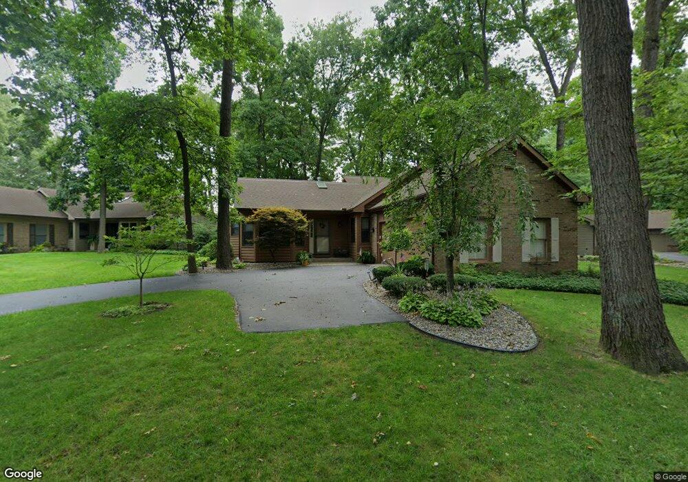
7745 W Street Andrews Cir Portage, MI 49024
Estimated Value: $318,000 - $376,000
2
Beds
2
Baths
1,589
Sq Ft
$213/Sq Ft
Est. Value
About This Home
This home is located at 7745 W Street Andrews Cir, Portage, MI 49024 and is currently estimated at $338,481, approximately $213 per square foot. 7745 W Street Andrews Cir is a home located in Kalamazoo County with nearby schools including Moorsbridge Elementary School, Portage West Middle School, and Portage Central High School.
Ownership History
Date
Name
Owned For
Owner Type
Purchase Details
Closed on
Apr 6, 2021
Sold by
Haines Edward J and Haines Catherine E
Bought by
Haines Edward J and Haines Catherine E
Current Estimated Value
Purchase Details
Closed on
Dec 21, 2011
Sold by
Connors Shawn M
Bought by
Haines Edward J and Haines Catherine E
Purchase Details
Closed on
Jan 25, 2006
Sold by
Connors Martina A
Bought by
Connors Martina A and The Martina A Connors Revocable Trust
Create a Home Valuation Report for This Property
The Home Valuation Report is an in-depth analysis detailing your home's value as well as a comparison with similar homes in the area
Home Values in the Area
Average Home Value in this Area
Purchase History
| Date | Buyer | Sale Price | Title Company |
|---|---|---|---|
| Haines Edward J | -- | None Available | |
| Haines Edward J | $162,950 | Ppr Title | |
| Connors Martina A | -- | None Available |
Source: Public Records
Tax History Compared to Growth
Tax History
| Year | Tax Paid | Tax Assessment Tax Assessment Total Assessment is a certain percentage of the fair market value that is determined by local assessors to be the total taxable value of land and additions on the property. | Land | Improvement |
|---|---|---|---|---|
| 2025 | $6,234 | $184,000 | $0 | $0 |
| 2024 | $5,488 | $166,300 | $0 | $0 |
| 2023 | $5,376 | $170,600 | $0 | $0 |
| 2022 | $5,809 | $151,700 | $0 | $0 |
| 2021 | $5,615 | $157,200 | $0 | $0 |
| 2020 | $5,492 | $172,400 | $0 | $0 |
| 2019 | $495 | $158,100 | $0 | $0 |
| 2018 | $0 | $142,800 | $0 | $0 |
| 2017 | $0 | $141,800 | $0 | $0 |
| 2016 | -- | $132,200 | $0 | $0 |
| 2015 | -- | $110,700 | $0 | $0 |
| 2014 | -- | $105,400 | $0 | $0 |
Source: Public Records
Map
Nearby Homes
- 3653 Tartan Cir
- 7922 Kilmory Cir
- 7961 Kilmory Cir
- 8030 Wimbledon Dr Unit 35
- 4788 Norfolk Cir
- 7236 Hampstead Ln Unit 18
- 7464 Saint George Cir
- 7481 Turnberry Ct
- 7639 Dunross Dr
- 7951 S 12th St
- 3320 Scots Pine Way Unit 2
- 3737 Bellflower Dr
- 3522 Bellflower Dr
- 7873 Shepherds Glen Ct
- 4280 Romence Rd
- 3638 Bellflower Dr
- 2600 W Centre Ave Unit +/- 1 Acre
- 2351 W Centre Ave
- 2076 Lion Gate Dr
- 5260 Saddle Club Dr
- 7745 W Saint Andrews Cir
- 7745 W Saint Andrews Cir
- 7795 W Street Andrews Cir
- 7705 W Street Andrews Cir Unit 17
- 7705 W Saint Andrews Cir Unit 17
- 7761 E Street Andrews Cir
- 7761 W Saint Andrews Cir
- 7761 W Saint Andrews Cir
- 7790 W Street Andrews Cir
- 7688 W Street Andrews Cir
- 7688 W Saint Andrews Cir
- 7787 W Saint Andrews Cir
- 7787 W Street Andrews Cir
- 7748 W Street Andrews Cir Unit 15
- 7748 W Saint Andrews Cir
- 7748 W Saint Andrews Cir
- 7688 W St Andrews Cir
- 7774 E Street Andrews Cir
- 7690 W Saint Andrews Cir
- 7770 W Street Andrews Cir Unit 16