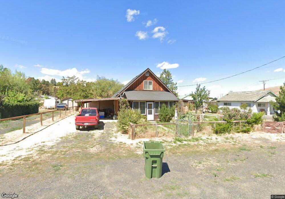
775 N Shobe Rd Heppner, OR 97836
Estimated Value: $230,895 - $239,000
3
Beds
2
Baths
1,504
Sq Ft
$156/Sq Ft
Est. Value
About This Home
This home is located at 775 N Shobe Rd, Heppner, OR 97836 and is currently estimated at $234,948, approximately $156 per square foot. 775 N Shobe Rd is a home located in Morrow County with nearby schools including Heppner Elementary School and Heppner Junior/Senior High School.
Ownership History
Date
Name
Owned For
Owner Type
Purchase Details
Closed on
Sep 16, 2014
Sold by
Branch Banking And Trust Co
Bought by
The Secretary Of Veterans Affairs
Current Estimated Value
Purchase Details
Closed on
Aug 28, 2014
Sold by
Padberg Luke
Bought by
Branch Banking And Trust Co
Purchase Details
Closed on
Dec 24, 2012
Sold by
Nagel Duane A and Nagel Catana K
Bought by
Padberg Luke
Home Financials for this Owner
Home Financials are based on the most recent Mortgage that was taken out on this home.
Original Mortgage
$85,295
Interest Rate
3.27%
Mortgage Type
VA
Create a Home Valuation Report for This Property
The Home Valuation Report is an in-depth analysis detailing your home's value as well as a comparison with similar homes in the area
Purchase History
| Date | Buyer | Sale Price | Title Company |
|---|---|---|---|
| The Secretary Of Veterans Affairs | $76,545 | Amerititle | |
| Branch Banking And Trust Co | $76,545 | Amerititle | |
| Padberg Luke | -- | Amerititle |
Source: Public Records
Mortgage History
| Date | Status | Borrower | Loan Amount |
|---|---|---|---|
| Previous Owner | Padberg Luke | $85,295 |
Source: Public Records
Tax History
| Year | Tax Paid | Tax Assessment Tax Assessment Total Assessment is a certain percentage of the fair market value that is determined by local assessors to be the total taxable value of land and additions on the property. | Land | Improvement |
|---|---|---|---|---|
| 2025 | $2,358 | $87,620 | -- | -- |
| 2024 | $2,045 | $85,070 | -- | -- |
| 2023 | $1,987 | $82,600 | $0 | $0 |
| 2022 | $1,894 | $81,060 | $0 | $0 |
| 2021 | $1,714 | $78,700 | $0 | $0 |
| 2020 | $1,721 | $78,700 | $0 | $0 |
| 2019 | $1,639 | $76,410 | $0 | $0 |
Source: Public Records
Map
Nearby Homes
- 440 W Riverside St
- 387 E Linden Way
- 280 Water St
- 175 W Baltimore St
- 315 N Gale St
- 280 W Center St
- 260 W Center St
- 300 N Chase St
- 310 N Chase St
- 240 N Court St
- 140 S Chase St
- 120 N Gilmore St
- 220 E Cannon St
- 235 Rock St
- 615 Hager St
- 61476 Dee Cox Rd
- 680 S Alfalfa St
- 60111 Stock Drive Rd
- 110 N Gilmore St
- 64209 Meadow Brook Rd
- 785 N Shobe Rd
- 735 N Shobe Rd
- 380 W Riverside St
- 715 N Shobe Rd
- 385 W Union Ave
- 390 W Union Ave
- 375 W Union Ave
- 380 W Union Ave
- 462 West St
- 458 W Morgan St
- 460 West St
- 370 W Union Ave
- 355 W Union Ave
- 468 W Morgan St
- 740 N A St
- 335 W Union Ave
- 340 W Union Ave
- 480 West St
- 360 W Union Ave
- 330 W Union Ave
Your Personal Tour Guide
Ask me questions while you tour the home.