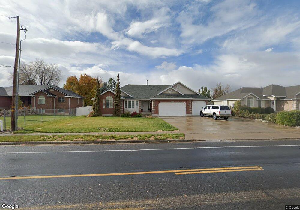
776 Flint St Layton, UT 84041
Estimated Value: $503,000 - $650,000
3
Beds
2
Baths
3,256
Sq Ft
$177/Sq Ft
Est. Value
About This Home
This home is located at 776 Flint St, Layton, UT 84041 and is currently estimated at $577,808, approximately $177 per square foot. 776 Flint St is a home located in Davis County with nearby schools including Layton Elementary School, Fairfield Junior High School, and Davis High School.
Ownership History
Date
Name
Owned For
Owner Type
Purchase Details
Closed on
Jun 25, 2013
Sold by
Woods Barry L and Woods Judith Anne
Bought by
Woods Barry and Woods Judith
Current Estimated Value
Purchase Details
Closed on
Oct 26, 2009
Sold by
Campbell Daniel H and Campbell Katie Lynn
Bought by
Woods Barry I and Woods Judith Anne
Purchase Details
Closed on
Dec 13, 2000
Sold by
Campbell Daniel H
Bought by
Campbell Daniel H and Campbell Katie Lynn
Purchase Details
Closed on
Nov 27, 2000
Sold by
L Dale Green Construction Inc
Bought by
Campbell Daniel H
Purchase Details
Closed on
Feb 4, 2000
Sold by
Green & Green Lc
Bought by
L Dale Green Construction Inc
Home Financials for this Owner
Home Financials are based on the most recent Mortgage that was taken out on this home.
Original Mortgage
$165,000
Interest Rate
8.06%
Mortgage Type
Construction
Create a Home Valuation Report for This Property
The Home Valuation Report is an in-depth analysis detailing your home's value as well as a comparison with similar homes in the area
Home Values in the Area
Average Home Value in this Area
Purchase History
| Date | Buyer | Sale Price | Title Company |
|---|---|---|---|
| Woods Barry | -- | None Available | |
| Woods Barry I | -- | Bonneville Superior Title Co | |
| Campbell Daniel H | -- | Security Title Company | |
| Campbell Daniel H | -- | Security Title Company | |
| L Dale Green Construction Inc | -- | Security Title Company |
Source: Public Records
Mortgage History
| Date | Status | Borrower | Loan Amount |
|---|---|---|---|
| Previous Owner | L Dale Green Construction Inc | $165,000 |
Source: Public Records
Tax History Compared to Growth
Tax History
| Year | Tax Paid | Tax Assessment Tax Assessment Total Assessment is a certain percentage of the fair market value that is determined by local assessors to be the total taxable value of land and additions on the property. | Land | Improvement |
|---|---|---|---|---|
| 2025 | $3,039 | $319,000 | $134,021 | $184,979 |
| 2024 | $2,824 | $298,650 | $140,279 | $158,371 |
| 2023 | $2,838 | $529,000 | $172,477 | $356,523 |
| 2022 | $3,097 | $313,500 | $95,607 | $217,893 |
| 2021 | $2,551 | $385,000 | $143,353 | $241,647 |
| 2020 | $2,313 | $335,000 | $123,797 | $211,203 |
| 2019 | $2,383 | $338,000 | $119,171 | $218,829 |
| 2018 | $2,177 | $310,000 | $105,371 | $204,629 |
| 2016 | $2,292 | $168,355 | $41,625 | $126,730 |
| 2015 | $2,278 | $158,840 | $41,625 | $117,215 |
| 2014 | $2,335 | $166,483 | $41,625 | $124,858 |
| 2013 | -- | $140,758 | $40,839 | $99,919 |
Source: Public Records
Map
Nearby Homes
- 268 E 900 S
- 282 E 925 S
- 267 S Melody St
- 774 W Farming Way
- 174 W Dawson St
- 256 Seemore Dr
- 562 S 850 W
- 1429 W Lincoln Way
- 473 E Alice Way
- 493 E Alice Way
- 2056 W Phillips St
- 1038 S Old Towne Rd
- 593 Kimball Dr
- 714 Rose Blossom Dr
- 71 S Harvs Ln
- 877 S Main St Unit B
- 1042 W Shoreline Dr
- 355 W Gentile St
- 129 N Mountain Vistas Rd
- 678 E Creekview Dr