
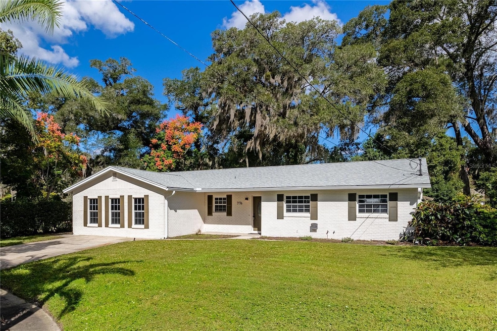


776 Mockingbird Ln Deland, FL 32720
West DeLand NeighborhoodEstimated payment $2,412/month
Total Views
158,904
3
Beds
2
Baths
2,002
Sq Ft
$189
Price per Sq Ft
Highlights
- In Ground Pool
- Bonus Room
- Stone Countertops
- Traditional Architecture
- Pool View
- No HOA
About This Home
One or more photo(s) has been virtually staged. Welcome to 776 Mockingbird Lane in beautiful DeLand, Florida! Nestled on a quiet cul-de-sac, this character-filled home has been lovingly updated from top to bottom and offers the perfect blend of charm and modern comfort. With 3 bedrooms, 2 bathrooms, formal living and dining rooms, a cozy family room, and a versatile bonus room that can easily serve as a 4th bedroom, home office, or playroom—you’ll have all the space you need to live, work, and play. Step inside to discover a stunning new kitchen featuring quartz countertops, brand-new stainless steel appliances, stylish fixtures, and a sunny eat-in nook that’s perfect for casual meals. Freshly painted inside and out, the home feels bright and welcoming, with all-new lighting, hardware, and plush carpet throughout. Both bathrooms have been tastefully renovated with modern vanities and designer touches. Outside, your private backyard retreat awaits! Enjoy the sparkling pool, basketball hoop, and a large storage shed—ideal for tools, toys, or hobbies. Plus, you’ll love the peace of mind that comes with a brand-new roof, new pool filter, new front door, and so many other updates. Located near the water for boating and outdoor fun, and just minutes from airports, shopping, dining, and transportation, this home offers the best of both worlds—peaceful living with convenient access to everything you need. Full of warmth, style, and thoughtful upgrades, 776 Mockingbird Lane is truly move-in ready and waiting for you to call it home! Ask your lender about a USDA loan. 100% Financing Available!!!
Listing Agent
SHAWFIELD REALTY GROUP Brokerage Phone: 888-650-5553 License #3349239 Listed on: 10/25/2025
Co-Listing Agent
SHAWFIELD REALTY GROUP Brokerage Phone: 888-650-5553 License #3324836
Home Details
Home Type
- Single Family
Est. Annual Taxes
- $5,018
Year Built
- Built in 1974
Lot Details
- 6,930 Sq Ft Lot
- Lot Dimensions are 66x105
- Cul-De-Sac
- North Facing Home
- Mature Landscaping
- Level Lot
- Landscaped with Trees
- Property is zoned 01R3
Home Design
- Traditional Architecture
- Slab Foundation
- Shingle Roof
- Concrete Siding
- Block Exterior
Interior Spaces
- 2,002 Sq Ft Home
- 1-Story Property
- Ceiling Fan
- Sliding Doors
- Entrance Foyer
- Family Room
- Combination Dining and Living Room
- Bonus Room
- Storage Room
- Pool Views
- Walk-Up Access
Kitchen
- Eat-In Kitchen
- Range
- Dishwasher
- Stone Countertops
- Solid Wood Cabinet
Flooring
- Carpet
- Ceramic Tile
Bedrooms and Bathrooms
- 3 Bedrooms
- 2 Full Bathrooms
Parking
- Parking Pad
- Oversized Parking
- Driveway
- Open Parking
Pool
- In Ground Pool
- Gunite Pool
Outdoor Features
- Covered Patio or Porch
- Exterior Lighting
- Separate Outdoor Workshop
- Shed
- Private Mailbox
Schools
- Woodward Avenue Elem-Vo Elementary School
- Southwestern Middle School
- Deland High School
Utilities
- Central Heating and Cooling System
- Thermostat
- 1 Water Well
- 1 Septic Tank
- High Speed Internet
- Phone Available
- Cable TV Available
Community Details
- No Home Owners Association
- Audubon Park Subdivision
Listing and Financial Details
- Visit Down Payment Resource Website
- Legal Lot and Block 37 / 0370
- Assessor Parcel Number 7018-22-00-0370
Matterport 3D Tour
Floorplan
Map
Create a Home Valuation Report for This Property
The Home Valuation Report is an in-depth analysis detailing your home's value as well as a comparison with similar homes in the area
Home Values in the Area
Average Home Value in this Area
Tax History
| Year | Tax Paid | Tax Assessment Tax Assessment Total Assessment is a certain percentage of the fair market value that is determined by local assessors to be the total taxable value of land and additions on the property. | Land | Improvement |
|---|---|---|---|---|
| 2026 | $4,985 | $267,062 | $29,700 | $237,362 |
| 2025 | $4,985 | $263,342 | $29,700 | $233,642 |
| 2024 | $4,846 | $261,200 | $26,730 | $234,470 |
| 2023 | $4,846 | $255,906 | $22,275 | $233,631 |
| 2022 | $4,475 | $226,261 | $22,275 | $203,986 |
| 2021 | $1,239 | $92,823 | $0 | $0 |
| 2020 | $1,212 | $91,541 | $0 | $0 |
| 2019 | $1,223 | $89,483 | $0 | $0 |
| 2018 | $1,194 | $87,815 | $0 | $0 |
| 2017 | $1,160 | $86,009 | $0 | $0 |
| 2016 | $1,096 | $84,240 | $0 | $0 |
| 2015 | $1,110 | $83,654 | $0 | $0 |
| 2014 | $1,095 | $82,990 | $0 | $0 |
Source: Public Records
Property History
| Date | Event | Price | List to Sale | Price per Sq Ft |
|---|---|---|---|---|
| 01/31/2026 01/31/26 | Price Changed | $379,000 | -2.6% | $189 / Sq Ft |
| 10/25/2025 10/25/25 | For Sale | $389,000 | -- | $194 / Sq Ft |
Source: Stellar MLS
Purchase History
| Date | Type | Sale Price | Title Company |
|---|---|---|---|
| Warranty Deed | $150,000 | -- | |
| Warranty Deed | $150,000 | -- | |
| Deed | $33,500 | -- |
Source: Public Records
About the Listing Agent
You need Realtors in your corner that understands all of the many pitfalls of buying and selling. Negotiations, contracts, financing, appraisals and inspections can quickly become overwhelming. They protect and support our clients in each phase to make sure the deal gets done right. They can help you get started in your search: www.shawfieldrealty.com. We sell HAPPY real estate!!
Carrie's Other Listings
Source: Stellar MLS
MLS Number: O6354289
APN: 7018-22-00-0370
Disclaimer: Certain information contained herein is derived from information provided by parties other than Homes.com. All information provided is deemed reliable, but is not guaranteed to be accurate and should be independently verified.
![]() Based on information submitted to the MLS GRID. All data is obtained from various sources and may not have been verified by broker or MLS GRID. Supplied Open House Information is subject to change without notice. All information should be independently reviewed and verified for accuracy. Properties may or may not be listed by the office/agent presenting the information. Some IDX listings have been excluded from this website. IDX information is provided exclusively for personal, non-commercial use, and may not be used for any purpose other than to identify prospective properties consumers may be interested in purchasing. Information is deemed reliable but not guaranteed.
Based on information submitted to the MLS GRID. All data is obtained from various sources and may not have been verified by broker or MLS GRID. Supplied Open House Information is subject to change without notice. All information should be independently reviewed and verified for accuracy. Properties may or may not be listed by the office/agent presenting the information. Some IDX listings have been excluded from this website. IDX information is provided exclusively for personal, non-commercial use, and may not be used for any purpose other than to identify prospective properties consumers may be interested in purchasing. Information is deemed reliable but not guaranteed.
Based on information submitted to the MLS GRID
Listing Information presented by local MLS brokerage: Ten-X - (888)-952-6393
Nearby Homes
- 718 Gracie Ct
- 0 W Beresford Ave Unit MFRV4945851
- 570 Cass St
- 619 Rhodes Dr
- 609 Rhodes Dr
- 761 S Pearl St
- 1559 W Euclid Ave
- 345 S Ridgewood Ave
- 1410 Talton Ave
- 414 Holly Fern Trail
- 905 W Beresford Ave
- 1196 Happy Forest Lp
- 1186 Happy Forest Lp
- 1256 White Ash Loop
- 1726 Lady Fern Trail
- 1610 Strathcona Ave
- 407 Pelham Park Dr
- 1240 W Voorhis Ave
- 915 S Spring Garden Ave
- 1237 White Ash Loop
- 2108 Old New York Ave
- 610 S Boundary Ave
- 905 Valleydale Ave
- 302 S Spring Garden Ave Unit B09
- 307 S Montgomery Ave Unit A
- 737 S Stone St
- 300 Spg Gdn Ave S
- 1430 Monroe St
- 916 W Wisconsin Ave
- 1531 S Montgomery St
- 141 Crawl Key Ct
- 1581 S Montgomery St
- 1250 Lakeview Dr Unit 36
- 1612 S High St
- 647 S Delaware Ave
- 119 N Orange Ave Unit 2
- 1670 S High St
- 416 W Howry Ave
- 214 W Volusia Ave
- 1820 Azalea Ln
Your Personal Tour Guide
Ask me questions while you tour the home.