Estimated Value: $182,000 - $264,000
3
Beds
2
Baths
1,700
Sq Ft
$138/Sq Ft
Est. Value
About This Home
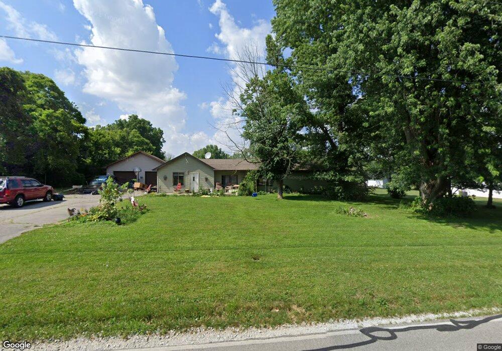
This home is located at 7760 E Landersdale Rd, Camby, IN 46113 and is currently estimated at $234,283, approximately $137 per square foot. 7760 E Landersdale Rd is a home located in Morgan County with nearby schools including Mooresville High School.
Ownership History
Date
Name
Owned For
Owner Type
Purchase Details
Closed on
Jul 19, 2011
Sold by
Pennington Angela and Pennington Shane
Bought by
Ogles Timothy G and Ogles Rhonda J
Current Estimated Value
Home Financials for this Owner
Home Financials are based on the most recent Mortgage that was taken out on this home.
Original Mortgage
$131,088
Outstanding Balance
$90,227
Interest Rate
4.52%
Mortgage Type
New Conventional
Estimated Equity
$144,056
Purchase Details
Closed on
Mar 17, 2011
Sold by
Hsbc Bank Usa Na
Bought by
Pennington Angela and Pennington Shane
Purchase Details
Closed on
Feb 7, 2011
Sold by
Addair Quentin and Addair Kelly
Bought by
Hsbc Bank Usa N A
Purchase Details
Closed on
May 23, 2006
Sold by
Addair Leonard A
Bought by
Addair Quentin and Addair Kelly
Home Financials for this Owner
Home Financials are based on the most recent Mortgage that was taken out on this home.
Original Mortgage
$127,000
Interest Rate
10.02%
Mortgage Type
Adjustable Rate Mortgage/ARM
Create a Home Valuation Report for This Property
The Home Valuation Report is an in-depth analysis detailing your home's value as well as a comparison with similar homes in the area
Home Values in the Area
Average Home Value in this Area
Purchase History
| Date | Buyer | Sale Price | Title Company |
|---|---|---|---|
| Ogles Timothy G | -- | -- | |
| Pennington Angela | $55,500 | -- | |
| Hsbc Bank Usa N A | $27,500 | -- | |
| Addair Quentin | -- | None Available |
Source: Public Records
Mortgage History
| Date | Status | Borrower | Loan Amount |
|---|---|---|---|
| Open | Ogles Timothy G | $131,088 | |
| Previous Owner | Addair Quentin | $127,000 |
Source: Public Records
Tax History Compared to Growth
Tax History
| Year | Tax Paid | Tax Assessment Tax Assessment Total Assessment is a certain percentage of the fair market value that is determined by local assessors to be the total taxable value of land and additions on the property. | Land | Improvement |
|---|---|---|---|---|
| 2024 | $874 | $188,400 | $46,600 | $141,800 |
| 2023 | $803 | $188,900 | $46,600 | $142,300 |
| 2022 | $751 | $171,000 | $46,600 | $124,400 |
| 2021 | $507 | $138,300 | $32,900 | $105,400 |
| 2020 | $492 | $134,200 | $32,900 | $101,300 |
| 2019 | $426 | $121,600 | $32,900 | $88,700 |
| 2018 | $367 | $114,800 | $32,900 | $81,900 |
| 2017 | $371 | $114,200 | $32,900 | $81,300 |
| 2016 | $373 | $114,200 | $32,900 | $81,300 |
| 2014 | $372 | $115,800 | $32,900 | $82,900 |
| 2013 | $372 | $116,200 | $32,900 | $83,300 |
Source: Public Records
Map
Nearby Homes
- 00 Boncquet Terrace
- 13346 N Miller Dr
- 7147 E Rising Sun Cir S
- 12196 N Beth Ann Dr
- 13852 N Fairwood Dr
- 13885 N Rising Sun Cir E
- 13841 N Cardonia Dr
- 11835 N Bens Ct
- 7421 Big Bend Blvd
- 7445 Big Bend Blvd
- 11828 N Bens Ct
- 7509 Big Bend Blvd
- 7525 Big Bend Blvd
- 7533 Big Bend Blvd
- 13829 N Kennard Way
- 13849 N Kennard Way
- Bellamy Plan at Parks at Decatur
- Holcombe Plan at Parks at Decatur
- Chatham Plan at Parks at Decatur
- Freeport Plan at Parks at Decatur
- 7778 E Landersdale Rd
- 7773 E Landersdale Rd
- 12976 N Robertson St
- 13070 N Forest Dr
- 7731 E Landersdale Rd
- 13041 N Forest Dr
- 12967 N Robertson St
- 13092 N Forest Dr
- 7858 E Landersdale Rd
- 7705 E Landersdale Rd
- 12954 N Robertson St
- 7668 E Landersdale Rd
- 13091 N Forest Dr
- 13110 N Forest Dr
- 12929 N Robertson St
- 7847 E Landersdale Rd
- 7870 E Landersdale Rd
- 7875 E Landersdale Rd
- 13109 N Forest Dr
- 12912 N Robertson St