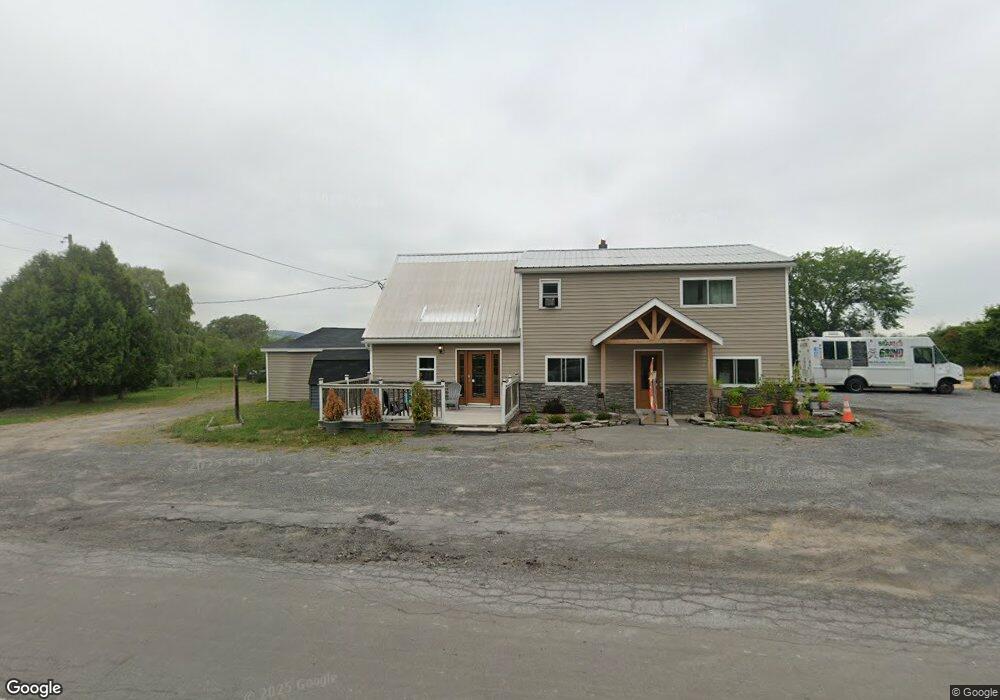
7763 State Route 20 Madison, NY 13402
Estimated Value: $77,224
--
Bed
--
Bath
3,280
Sq Ft
$24/Sq Ft
Est. Value
About This Home
This home is located at 7763 State Route 20, Madison, NY 13402 and is currently estimated at $77,224, approximately $23 per square foot. 7763 State Route 20 is a home located in Madison County with nearby schools including Madison Central School.
Ownership History
Date
Name
Owned For
Owner Type
Purchase Details
Closed on
Oct 20, 2022
Sold by
Dwyer Development Llc
Bought by
Gehrig Andrew
Current Estimated Value
Purchase Details
Closed on
May 17, 2012
Sold by
Joyce Stephen P
Bought by
Dwyer Development Llc
Purchase Details
Closed on
Oct 11, 2011
Sold by
Madison County
Bought by
Joyce Stephen
Purchase Details
Closed on
Sep 2, 2011
Sold by
Kobler Darlene
Bought by
Madison County
Purchase Details
Closed on
Feb 24, 2000
Sold by
Jeffris Lucy
Bought by
Kobler Darlene
Create a Home Valuation Report for This Property
The Home Valuation Report is an in-depth analysis detailing your home's value as well as a comparison with similar homes in the area
Home Values in the Area
Average Home Value in this Area
Purchase History
| Date | Buyer | Sale Price | Title Company |
|---|---|---|---|
| Gehrig Andrew | $75,000 | -- | |
| Dwyer Development Llc | $37,500 | -- | |
| Joyce Stephen | $20,000 | -- | |
| Madison County | -- | -- | |
| Kobler Darlene | $54,000 | Paul Gallagher |
Source: Public Records
Tax History Compared to Growth
Tax History
| Year | Tax Paid | Tax Assessment Tax Assessment Total Assessment is a certain percentage of the fair market value that is determined by local assessors to be the total taxable value of land and additions on the property. | Land | Improvement |
|---|---|---|---|---|
| 2024 | $1,959 | $42,000 | $11,600 | $30,400 |
| 2023 | $1,947 | $42,000 | $11,600 | $30,400 |
| 2022 | $1,850 | $42,000 | $11,600 | $30,400 |
| 2021 | $1,805 | $42,000 | $11,600 | $30,400 |
| 2020 | $1,796 | $42,000 | $11,600 | $30,400 |
| 2019 | $1,759 | $42,000 | $11,600 | $30,400 |
| 2018 | $1,759 | $42,000 | $11,600 | $30,400 |
| 2017 | $1,715 | $42,000 | $11,600 | $30,400 |
| 2016 | $1,654 | $42,000 | $11,600 | $30,400 |
| 2015 | -- | $42,000 | $11,600 | $30,400 |
| 2014 | -- | $40,000 | $11,600 | $28,400 |
Source: Public Records
Map
Nearby Homes
- 0 Water St
- 3992 Center Rd
- 0 New York 12b
- 0WP Lake Moraine Rd
- 00 Lake Moraine Rd
- 7270 State Route 20
- 177 Madison St
- 109 Augusta Rd
- 135 Augusta Rd Unit W
- 152 S Main St
- 111 Maple Ave
- 108 S Main St
- 138 N Main St
- 123 College St Unit WS
- 3822 Canal Rd
- 5612 E Lake Rd
- 6778 State Route 20
- 1348 Brothertown Rd Unit ES
- 1530 Brothertown Rd
- 0 Johnny Cake Hill Rd Unit S1570699
- 7749 State Route 20
- 7706 State Route 20
- 4439 State Route 12b
- 4461 State Route 12b
- 7694 State Route 20
- 7684 State Route 20
- 3742 Lovejoy Rd
- 7834 Water St
- 7830 Water St
- 7728 Water St
- 7584 State Route 20
- 7585 State Route 20
- 7843 Water St
- 4595 State Route 12b
- 7906 Water St
- 7581 State Route 20
- 3658 Lovejoy Rd
- 7906 Water St
- 7561 State Route 20
- 7555 State Route 20