Estimated Value: $316,738 - $385,000
--
Bed
3
Baths
1,804
Sq Ft
$201/Sq Ft
Est. Value
About This Home
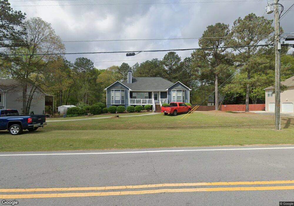
This home is located at 778 Poole Bridge Rd Unit 1, Hiram, GA 30141 and is currently estimated at $362,185, approximately $200 per square foot. 778 Poole Bridge Rd Unit 1 is a home located in Paulding County with nearby schools including Bessie L. Baggett Elementary School, Irma C. Austin Middle School, and Hiram High School.
Ownership History
Date
Name
Owned For
Owner Type
Purchase Details
Closed on
May 7, 2019
Sold by
Sammons Linda
Bought by
Sammons Linda and Sammons Jerry Lanier
Current Estimated Value
Purchase Details
Closed on
Nov 29, 2017
Sold by
Dr Horton Inc
Bought by
Jean Randolphe and Cajour Schestnot
Purchase Details
Closed on
Apr 20, 2017
Sold by
Not Provided
Bought by
Dr Horton Inc
Purchase Details
Closed on
Jul 30, 2003
Sold by
Turn Key Properties Inc
Bought by
Sammons Richard and Sammons Linda
Home Financials for this Owner
Home Financials are based on the most recent Mortgage that was taken out on this home.
Original Mortgage
$154,565
Interest Rate
5.88%
Mortgage Type
New Conventional
Create a Home Valuation Report for This Property
The Home Valuation Report is an in-depth analysis detailing your home's value as well as a comparison with similar homes in the area
Home Values in the Area
Average Home Value in this Area
Purchase History
| Date | Buyer | Sale Price | Title Company |
|---|---|---|---|
| Sammons Linda | -- | -- | |
| Jean Randolphe | $212,490 | -- | |
| Dr Horton Inc | -- | -- | |
| Sammons Richard | $162,700 | -- |
Source: Public Records
Mortgage History
| Date | Status | Borrower | Loan Amount |
|---|---|---|---|
| Previous Owner | Sammons Richard | $154,565 |
Source: Public Records
Tax History Compared to Growth
Tax History
| Year | Tax Paid | Tax Assessment Tax Assessment Total Assessment is a certain percentage of the fair market value that is determined by local assessors to be the total taxable value of land and additions on the property. | Land | Improvement |
|---|---|---|---|---|
| 2024 | $933 | $138,080 | $12,000 | $126,080 |
| 2023 | $1,040 | $131,028 | $12,000 | $119,028 |
| 2022 | $923 | $114,992 | $12,000 | $102,992 |
| 2021 | $1,022 | $103,172 | $12,000 | $91,172 |
| 2020 | $855 | $82,040 | $12,000 | $70,040 |
| 2019 | $727 | $75,920 | $12,000 | $63,920 |
| 2018 | $670 | $71,520 | $16,000 | $55,520 |
| 2017 | $648 | $67,520 | $16,000 | $51,520 |
| 2016 | $629 | $67,400 | $16,000 | $51,400 |
| 2015 | $709 | $71,840 | $16,000 | $55,840 |
| 2014 | $691 | $66,920 | $16,000 | $50,920 |
| 2013 | -- | $54,760 | $16,000 | $38,760 |
Source: Public Records
Map
Nearby Homes
- 798 Poole Bridge Rd Unit 1
- 752 Poole Bridge Rd Unit 1
- 303 Cross Pointe Way Unit 1
- 291 Cross Pointe Way Unit 1
- 15 Buckingham Dr
- 0 Buckingham Dr Unit 7239887
- 0 Buckingham Dr Unit 8701514
- 0 Buckingham Dr Unit 8565728
- 0 Buckingham Dr Unit 8035293
- 0 Buckingham Dr Unit 8086923
- 0 Buckingham Dr Unit 8750555
- 0 Buckingham Dr Unit 8750526
- 0 Buckingham Dr Unit 8853520
- 0 Buckingham Dr
- 787 Poole Bridge Rd
- 40 Brandon Woods Cir
- 14 Brandon Woods Cir
- 0 Cross Pointe Dr Unit 4
- 36 Buckingham Dr
- 35 Buckingham Dr