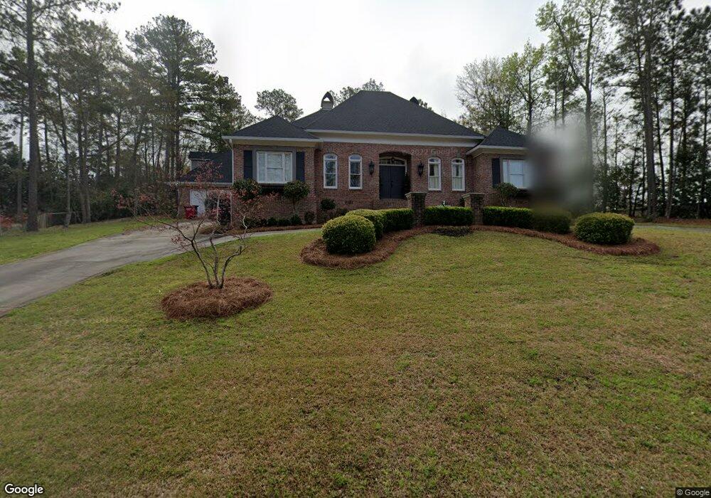
778 Saint Andrews Dr Macon, GA 31210
Estimated Value: $743,000 - $814,000
4
Beds
4
Baths
3,746
Sq Ft
$208/Sq Ft
Est. Value
About This Home
This home is located at 778 Saint Andrews Dr, Macon, GA 31210 and is currently estimated at $778,099, approximately $207 per square foot. 778 Saint Andrews Dr is a home located in Bibb County with nearby schools including Carter Elementary School, Howard Middle School, and Howard High School.
Ownership History
Date
Name
Owned For
Owner Type
Purchase Details
Closed on
Jun 30, 2017
Sold by
Danner Robert M
Bought by
Graham Kristy French
Current Estimated Value
Home Financials for this Owner
Home Financials are based on the most recent Mortgage that was taken out on this home.
Original Mortgage
$361,000
Outstanding Balance
$298,889
Interest Rate
3.94%
Mortgage Type
New Conventional
Estimated Equity
$479,210
Purchase Details
Closed on
Feb 25, 2002
Bought by
Danner Robert M
Purchase Details
Closed on
Apr 30, 1997
Create a Home Valuation Report for This Property
The Home Valuation Report is an in-depth analysis detailing your home's value as well as a comparison with similar homes in the area
Home Values in the Area
Average Home Value in this Area
Purchase History
| Date | Buyer | Sale Price | Title Company |
|---|---|---|---|
| Graham Kristy French | $380,000 | None Available | |
| Danner Robert M | $310,000 | -- | |
| -- | $33,900 | -- |
Source: Public Records
Mortgage History
| Date | Status | Borrower | Loan Amount |
|---|---|---|---|
| Open | Graham Kristy French | $361,000 |
Source: Public Records
Tax History Compared to Growth
Tax History
| Year | Tax Paid | Tax Assessment Tax Assessment Total Assessment is a certain percentage of the fair market value that is determined by local assessors to be the total taxable value of land and additions on the property. | Land | Improvement |
|---|---|---|---|---|
| 2025 | $6,359 | $258,765 | $53,280 | $205,485 |
| 2024 | $6,302 | $248,140 | $53,280 | $194,860 |
| 2023 | $5,872 | $231,196 | $53,280 | $177,916 |
| 2022 | $7,358 | $212,544 | $17,280 | $195,264 |
| 2021 | $7,582 | $199,526 | $17,280 | $182,246 |
| 2020 | $7,281 | $187,534 | $14,400 | $173,134 |
| 2019 | $6,679 | $170,611 | $14,400 | $156,211 |
| 2018 | $9,292 | $170,611 | $14,400 | $156,211 |
| 2017 | $5,980 | $166,602 | $14,400 | $152,202 |
| 2016 | $5,522 | $166,602 | $14,400 | $152,202 |
| 2015 | $7,816 | $166,602 | $14,400 | $152,202 |
| 2014 | $7,829 | $166,602 | $14,400 | $152,202 |
Source: Public Records
Map
Nearby Homes
- 4532 Ayers Rd
- 4571 Shadow Lawn Dr
- 4373 Barrington Place
- 3949 Bernice Ave
- 1402 Barrington Place
- 1406 Barrington Place
- 4403 Azalea Dr
- 4433 Azalea Dr
- 117 Legare Ct
- 534 Ivy Brook Way
- 776 Ivy Brook Way
- 621 Ivy Brook Way
- 740 Ivy Brook Way
- 631 Ivy Brook Way
- 715 Ivy Brook Way
- 2006 Fall Harvest Dr Unit LOT 278
- 2006 Fall Harvest Dr
- 2002 Fall Harvest Dr
- 2008 Fall Harvest Dr Unit LOT 277
- 2004 Fall Harvest Dr
- 770 St Andrews Dr
- 770 Saint Andrews Dr
- 777 Saint Andrews Dr
- 102 Westchester Park
- 786 Saint Andrews Dr
- 763 Saint Andrews Dr
- 760 Saint Andrews Dr
- 4635 Ayers Rd
- 790 Saint Andrews Dr
- 4640 Brooklawn St
- 4626 Saint Anne Ct
- 758 Saint Andrews Dr
- 4652 Brooklawn St
- 4658 Brooklawn St
- 4619 Ayers Rd
- 757 Saint Andrews Dr
- 4622 Saint Anne Ct
- 4666 Brooklawn St
- 794 Saint Andrews Dr
- 4672 Brooklawn St