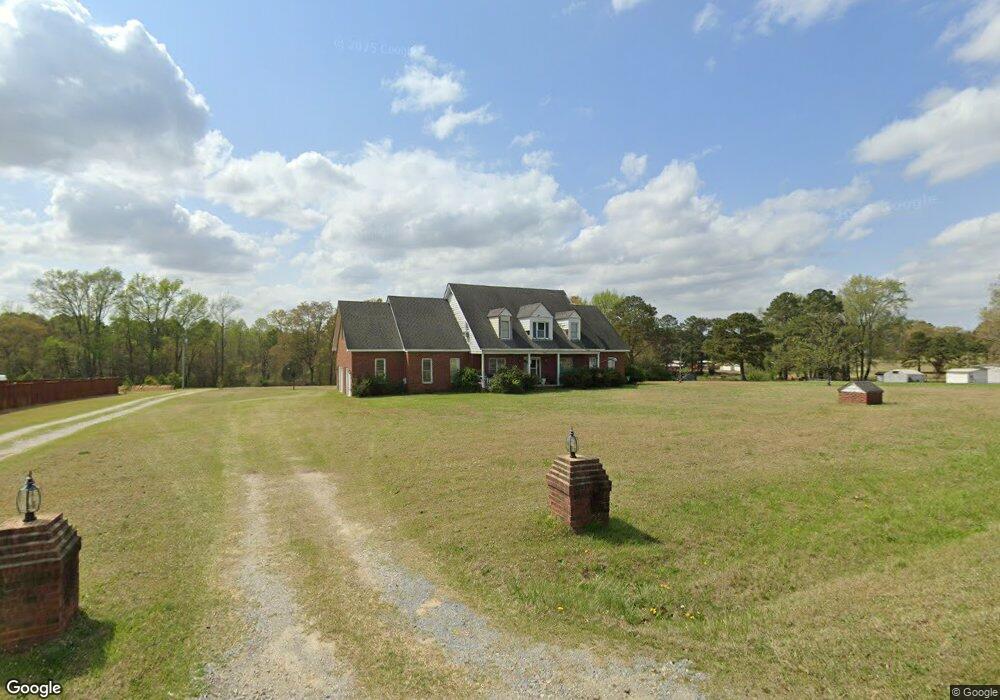
778 Wiggins Rd Angier, NC 27501
Pleasant Grove NeighborhoodEstimated Value: $492,266 - $583,000
2
Beds
2
Baths
2,996
Sq Ft
$180/Sq Ft
Est. Value
About This Home
This home is located at 778 Wiggins Rd, Angier, NC 27501 and is currently estimated at $538,817, approximately $179 per square foot. 778 Wiggins Rd is a home located in Johnston County with nearby schools including McGee's Crossroads Elementary School, McGee's Crossroads Middle School, and West Johnston High School.
Ownership History
Date
Name
Owned For
Owner Type
Purchase Details
Closed on
Mar 16, 2009
Sold by
Bowden Danny Joe and Bowden Amanda L
Bought by
Bowden Danny Joe and Bowden Amanda L
Current Estimated Value
Home Financials for this Owner
Home Financials are based on the most recent Mortgage that was taken out on this home.
Original Mortgage
$189,000
Interest Rate
5.13%
Mortgage Type
Purchase Money Mortgage
Create a Home Valuation Report for This Property
The Home Valuation Report is an in-depth analysis detailing your home's value as well as a comparison with similar homes in the area
Home Values in the Area
Average Home Value in this Area
Purchase History
| Date | Buyer | Sale Price | Title Company |
|---|---|---|---|
| Bowden Danny Joe | -- | Fidelity National Title Grou |
Source: Public Records
Mortgage History
| Date | Status | Borrower | Loan Amount |
|---|---|---|---|
| Closed | Bowden Danny Joe | $189,000 |
Source: Public Records
Tax History
| Year | Tax Paid | Tax Assessment Tax Assessment Total Assessment is a certain percentage of the fair market value that is determined by local assessors to be the total taxable value of land and additions on the property. | Land | Improvement |
|---|---|---|---|---|
| 2025 | $2,855 | $449,660 | $65,270 | $384,390 |
| 2024 | $2,260 | $279,050 | $31,000 | $248,050 |
| 2023 | $2,191 | $279,050 | $31,000 | $248,050 |
| 2022 | $2,260 | $279,050 | $31,000 | $248,050 |
| 2021 | $2,260 | $279,050 | $31,000 | $248,050 |
| 2020 | $2,344 | $279,050 | $31,000 | $248,050 |
| 2019 | $2,288 | $279,050 | $31,000 | $248,050 |
| 2018 | $2,029 | $241,560 | $24,480 | $217,080 |
| 2017 | $2,029 | $241,560 | $24,480 | $217,080 |
| 2016 | $2,029 | $241,560 | $24,480 | $217,080 |
| 2015 | $2,029 | $241,560 | $24,480 | $217,080 |
| 2014 | $2,029 | $241,560 | $24,480 | $217,080 |
Source: Public Records
Map
Nearby Homes
- 810 | 850 Wiggins Rd
- 105 Pinecrest Dr
- 506 Harbor Cove Dr
- 197 Silverside Dr
- 71 Suzanne Dr
- 264 Harbor Cove Dr
- 206 West Rd
- 131 Regal Pond Dr
- 3361 Old Fairground Rd
- 0 Massengill Pond Rd
- 69 Andorra Place
- 57 Andorra Place
- 16622 N Carolina 210
- 81 Pinon Dr
- 40 Broadhead Ct
- 139 Bounty Cir
- 16 Keystone Ct
- 205 Teresa Ct
- 369 Everland Pkwy
- 3002 Red Cir
- 812 Wiggins Rd
- 777 Wiggins Rd
- 730 Wiggins Rd
- 841 Wiggins Rd
- 870 Wiggins Rd
- 890 Wiggins Rd
- 690 Wiggins Rd
- 912 Wiggins Rd
- 670 Wiggins Rd
- 958 Wiggins Rd
- 16.1 Acres Wiggins Rd
- 680 Wiggins Rd
- 680 Wiggins Rd Unit F
- 680 Wiggins Rd Unit C
- 680 Wiggins Rd Unit B
- 49 N Creekcrest Ct
- 49 N Creekcrest Ct Unit 25
- 100 Old Mill Dr
- 104 Old Mill Dr
- 38 Marshview Cir
Your Personal Tour Guide
Ask me questions while you tour the home.