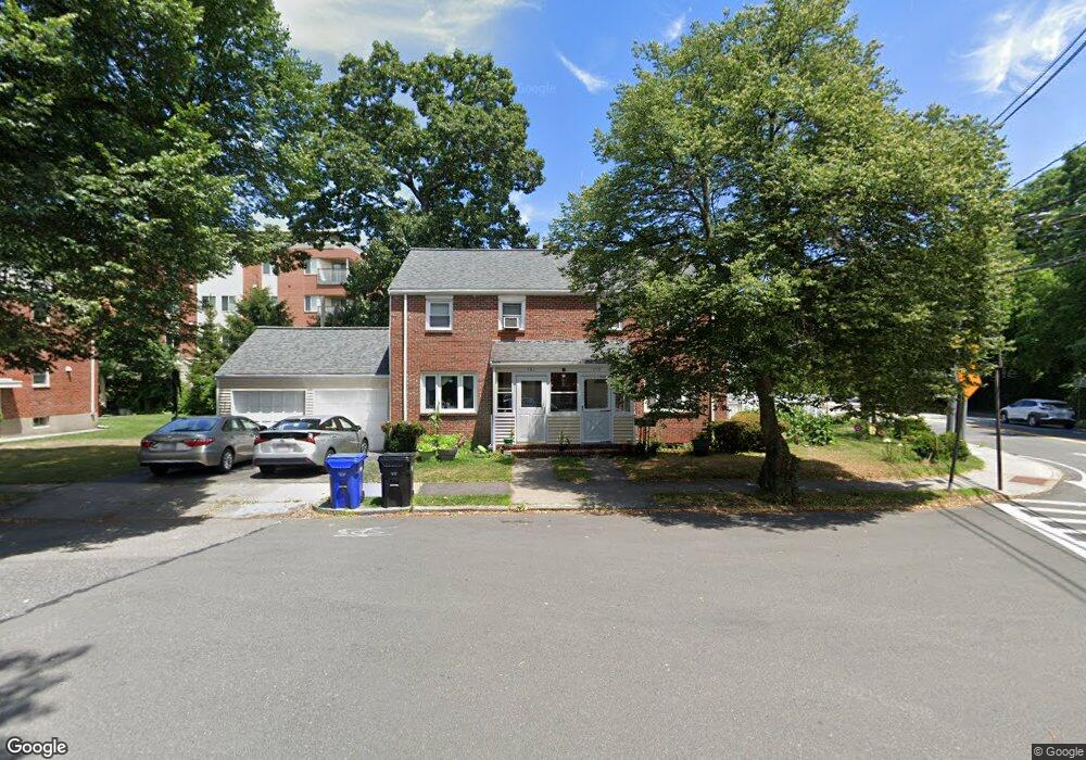
779 Heath St Unit 781 Chestnut Hill, MA 02467
South Brookline NeighborhoodEstimated Value: $1,136,000 - $1,508,000
4
Beds
2
Baths
1,728
Sq Ft
$742/Sq Ft
Est. Value
About This Home
This home is located at 779 Heath St Unit 781, Chestnut Hill, MA 02467 and is currently estimated at $1,283,034, approximately $742 per square foot. 779 Heath St Unit 781 is a home located in Norfolk County with nearby schools including Baker School, Mount Alvernia Academy, and Brimmer & May School.
Ownership History
Date
Name
Owned For
Owner Type
Purchase Details
Closed on
Mar 17, 1994
Sold by
Heath St Nt
Bought by
Chen Trasong
Current Estimated Value
Home Financials for this Owner
Home Financials are based on the most recent Mortgage that was taken out on this home.
Original Mortgage
$168,800
Interest Rate
6.9%
Mortgage Type
Purchase Money Mortgage
Purchase Details
Closed on
Oct 13, 1993
Sold by
Horney David J
Bought by
Heath St Nt
Create a Home Valuation Report for This Property
The Home Valuation Report is an in-depth analysis detailing your home's value as well as a comparison with similar homes in the area
Home Values in the Area
Average Home Value in this Area
Purchase History
| Date | Buyer | Sale Price | Title Company |
|---|---|---|---|
| Chen Trasong | $211,000 | -- | |
| Heath St Nt | $131,000 | -- |
Source: Public Records
Mortgage History
| Date | Status | Borrower | Loan Amount |
|---|---|---|---|
| Closed | Heath St Nt | $168,800 |
Source: Public Records
Tax History Compared to Growth
Tax History
| Year | Tax Paid | Tax Assessment Tax Assessment Total Assessment is a certain percentage of the fair market value that is determined by local assessors to be the total taxable value of land and additions on the property. | Land | Improvement |
|---|---|---|---|---|
| 2025 | $10,403 | $1,054,000 | $667,300 | $386,700 |
| 2024 | $10,157 | $1,039,600 | $641,700 | $397,900 |
| 2023 | $10,529 | $1,056,100 | $583,900 | $472,200 |
| 2022 | $10,249 | $1,005,800 | $556,100 | $449,700 |
| 2021 | $9,478 | $967,100 | $534,700 | $432,400 |
| 2020 | $8,832 | $934,600 | $486,200 | $448,400 |
| 2019 | $8,339 | $890,000 | $463,000 | $427,000 |
| 2018 | $8,344 | $882,000 | $464,000 | $418,000 |
| 2017 | $8,068 | $816,600 | $437,700 | $378,900 |
| 2016 | $7,736 | $742,400 | $409,100 | $333,300 |
| 2015 | $7,208 | $674,900 | $382,300 | $292,600 |
| 2014 | $7,026 | $616,900 | $347,500 | $269,400 |
Source: Public Records
Map
Nearby Homes
- 809-811 Heath St Unit 811
- 799 Heath St Unit 2
- 811 Heath St
- 321 Hammond Pond Pkwy Unit 103
- 321 Hammond Pond Pkwy Unit 301
- 5 Heathwood Ln
- 11 Hammond Pond Pkwy Unit 3
- 33 Hammond Pond Pkwy Unit 2
- 15 Glenland Rd
- 80 Louise Rd Unit 82
- 280 Boylston St Unit 203
- 280 Boylston St Unit 905
- 280 Boylston St Unit 710
- 280 Boylston St Unit 908
- 280 Boylston St Unit 415
- 280 Boylston St Unit 511
- 79 Florence St Unit 600S
- 79 Florence St Unit 402S
- 250 Hammond Pond Pkwy Unit 1604N
- 250 Hammond Pond Pkwy Unit 1002N
- 9 Belmont Rd Unit 11
- 9 Belmont Rd
- 9 Belmont Rd Unit N/A
- 9 Belmont Rd Unit 1
- 775 Heath St
- 775 Heath St
- 773 Heath St
- 773 Heath St
- 809-811 Heath St Unit 809
- 771 Heath St
- 771 Heath St Unit 771
- 771 Heath St
- 769 Heath St
- 769 Heath St Unit 769
- 769 Heath St
- 789 Heath St Unit 791
- 767 Heath St
- 767 Heath St
- 767 Heath St Unit 767
- 767 Heath St