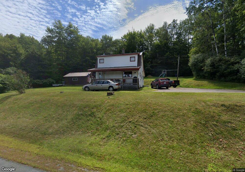
779 Lancaster Rd Lancaster, NH 03584
Estimated Value: $153,000 - $198,000
3
Beds
2
Baths
1,056
Sq Ft
$163/Sq Ft
Est. Value
About This Home
This home is located at 779 Lancaster Rd, Lancaster, NH 03584 and is currently estimated at $171,689, approximately $162 per square foot. 779 Lancaster Rd is a home located in Coos County with nearby schools including Groveton Elementary School, Groveton High School, and North Country Charter Academy Lancaster (M).
Ownership History
Date
Name
Owned For
Owner Type
Purchase Details
Closed on
Aug 5, 2016
Sold by
Tyler Betty E
Bought by
Tyler Cameron and Tyler Amelia
Current Estimated Value
Home Financials for this Owner
Home Financials are based on the most recent Mortgage that was taken out on this home.
Original Mortgage
$15,000
Outstanding Balance
$11,999
Interest Rate
3.56%
Mortgage Type
Stand Alone Second
Estimated Equity
$159,690
Create a Home Valuation Report for This Property
The Home Valuation Report is an in-depth analysis detailing your home's value as well as a comparison with similar homes in the area
Purchase History
We collect this data history from publicly available records. To have your information removed, we recommend requesting removal directly through your county’s website.
| Date | Buyer | Sale Price | Title Company |
|---|---|---|---|
| Tyler Cameron | $71,066 | -- |
Source: Public Records
Mortgage History
We collect this data history from publicly available records. To have your information removed, we recommend requesting removal directly through your county’s website.
| Date | Status | Borrower | Loan Amount |
|---|---|---|---|
| Open | Tyler Cameron | $15,000 |
Source: Public Records
Tax History
| Year | Tax Paid | Tax Assessment Tax Assessment Total Assessment is a certain percentage of the fair market value that is determined by local assessors to be the total taxable value of land and additions on the property. | Land | Improvement |
|---|---|---|---|---|
| 2024 | $3,022 | $134,650 | $65,000 | $69,650 |
| 2023 | $2,879 | $134,650 | $65,000 | $69,650 |
| 2022 | $2,369 | $71,650 | $18,900 | $52,750 |
| 2021 | $2,530 | $71,650 | $18,900 | $52,750 |
| 2020 | $2,365 | $71,650 | $18,900 | $52,750 |
| 2019 | $2,324 | $71,650 | $18,900 | $52,750 |
| 2018 | $2,490 | $71,650 | $18,900 | $52,750 |
| 2016 | $2,631 | $71,500 | $20,000 | $51,500 |
| 2015 | $2,480 | $71,500 | $20,000 | $51,500 |
| 2013 | $2,390 | $71,400 | $20,000 | $51,400 |
Source: Public Records
Map
Nearby Homes
- 7680 Vermont 102
- 413 Lancaster Rd
- 4593 Route 102
- 0 North Rd Unit 5065580
- 3 Chellie Ln
- 36 Longview Dr
- 101 Page Hill Rd
- Lot 12 Page Hill Rd
- 869 Lost Nation Rd
- 540 Lost Nation Rd
- 501 Fellows Rd
- 15 Rich St
- Lot 5 Kelsea Ave
- 0 Thompson Rd Unit 8
- 98 Boucher Rd
- 84 Hillside Ave
- 13 Hillside Ave
- 13 Fiske St
- 12 Crow Hill St
- 1326 Lost Nation Rd
- 789 Lancaster Rd
- 765 Lancaster Rd
- 755 Lancaster Rd Unit M236 L 19
- 755 Lancaster Rd
- 755 Lancaster Rd Unit M236 L019
- 755 Lancaster
- 755 Lancaster Unit M236 L019
- 755 Lancaster Unit M236 L 19
- 78 Alice Dr
- 82 Alice Dr
- 62 Alice Dr
- 753 Lancaster Rd
- 799 Lancaster Rd
- 50 Alice Dr
- 809 Lancaster Rd
- 743 Lancaster Rd
- 7006 Route 102
- 735 Lancaster Rd
- 10 Alice Dr
- 733 Lancaster Rd
Your Personal Tour Guide
Ask me questions while you tour the home.