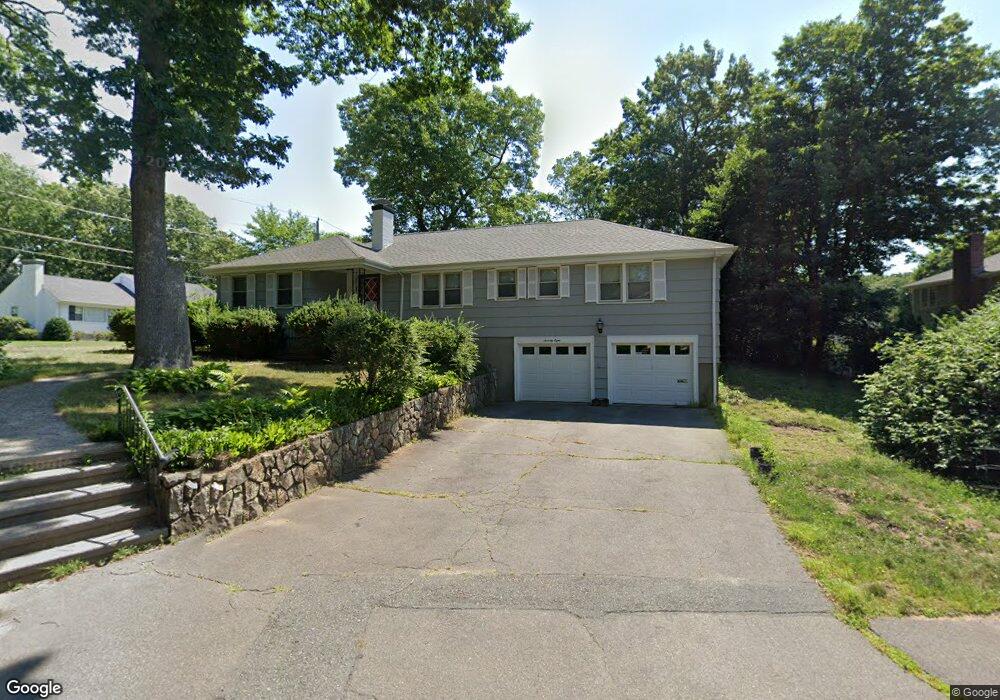
78 Ivy Rd Wellesley, MA 02482
Estimated Value: $1,451,000 - $1,507,402
4
Beds
3
Baths
1,896
Sq Ft
$783/Sq Ft
Est. Value
About This Home
This home is located at 78 Ivy Rd, Wellesley, MA 02482 and is currently estimated at $1,484,601, approximately $783 per square foot. 78 Ivy Rd is a home located in Norfolk County with nearby schools including Sprague Elementary School, Wellesley Middle School, and Wellesley Sr High School.
Ownership History
Date
Name
Owned For
Owner Type
Purchase Details
Closed on
May 28, 2010
Sold by
Snitzer Elias
Bought by
Wang Yi and Lee Hong-Hsi
Current Estimated Value
Home Financials for this Owner
Home Financials are based on the most recent Mortgage that was taken out on this home.
Original Mortgage
$250,000
Outstanding Balance
$168,860
Interest Rate
5.13%
Mortgage Type
Purchase Money Mortgage
Estimated Equity
$1,315,741
Purchase Details
Closed on
Jul 2, 2003
Sold by
Watts Harris G
Bought by
Snitzer Elias and Snitzer Shirley W
Home Financials for this Owner
Home Financials are based on the most recent Mortgage that was taken out on this home.
Original Mortgage
$322,700
Interest Rate
5.46%
Mortgage Type
Purchase Money Mortgage
Create a Home Valuation Report for This Property
The Home Valuation Report is an in-depth analysis detailing your home's value as well as a comparison with similar homes in the area
Purchase History
| Date | Buyer | Sale Price | Title Company |
|---|---|---|---|
| Wang Yi | $734,500 | -- | |
| Snitzer Elias | $642,000 | -- |
Source: Public Records
Mortgage History
| Date | Status | Borrower | Loan Amount |
|---|---|---|---|
| Open | Wang Yi | $250,000 | |
| Previous Owner | Snitzer Elias | $322,700 |
Source: Public Records
Tax History
| Year | Tax Paid | Tax Assessment Tax Assessment Total Assessment is a certain percentage of the fair market value that is determined by local assessors to be the total taxable value of land and additions on the property. | Land | Improvement |
|---|---|---|---|---|
| 2025 | $13,343 | $1,298,000 | $1,028,000 | $270,000 |
| 2024 | $12,419 | $1,193,000 | $934,000 | $259,000 |
| 2023 | $12,217 | $1,067,000 | $828,000 | $239,000 |
| 2022 | $11,516 | $986,000 | $711,000 | $275,000 |
| 2021 | $11,221 | $955,000 | $680,000 | $275,000 |
| 2020 | $11,040 | $955,000 | $680,000 | $275,000 |
| 2019 | $10,101 | $873,000 | $649,000 | $224,000 |
| 2018 | $9,632 | $806,000 | $631,000 | $175,000 |
| 2017 | $9,491 | $805,000 | $630,000 | $175,000 |
| 2016 | $9,334 | $789,000 | $620,000 | $169,000 |
| 2015 | $8,762 | $758,000 | $590,000 | $168,000 |
Source: Public Records
Map
Nearby Homes
- 33 Avon Rd
- 29 Pinewood Rd
- 25 Mansfield Rd
- 63 Oak St Unit B
- 148 Weston Rd Unit 208
- 148 Weston Rd Unit 207
- 16 Stearns Rd Unit 101
- 16 Stearns Rd Unit 106
- 16 Stearns Rd Unit 103
- 16 Stearns Rd Unit 301
- 16 Stearns Rd Unit 304
- 16 Stearns Rd Unit 104
- 63 Linden St Unit 1
- 100 Linden St Unit 111
- 18 Sprague Rd
- 201 Lowell Rd
- 5 Wilde Rd
- 23 Pilgrim Rd
- 5 Abbott St
- 39 Audubon Rd
Your Personal Tour Guide
Ask me questions while you tour the home.