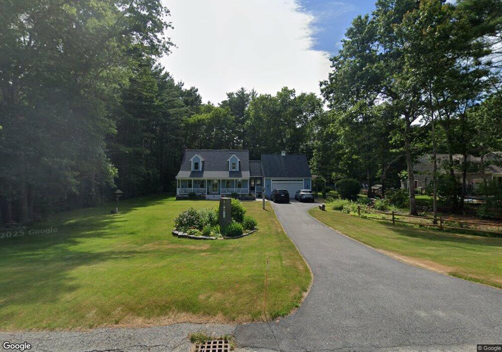
78 Stoney Weir Rd Halifax, MA 02338
Estimated Value: $551,000 - $803,000
3
Beds
2
Baths
1,677
Sq Ft
$400/Sq Ft
Est. Value
About This Home
This home is located at 78 Stoney Weir Rd, Halifax, MA 02338 and is currently estimated at $671,286, approximately $400 per square foot. 78 Stoney Weir Rd is a home located in Plymouth County with nearby schools including Silver Lake Regional High School, Halifax Elementary School, and Silver Lake Regional Middle School.
Ownership History
Date
Name
Owned For
Owner Type
Purchase Details
Closed on
Mar 12, 1996
Sold by
Pdc Enterprises Inc
Bought by
Bowles Dennis G and Mikkola Deborah A
Current Estimated Value
Create a Home Valuation Report for This Property
The Home Valuation Report is an in-depth analysis detailing your home's value as well as a comparison with similar homes in the area
Home Values in the Area
Average Home Value in this Area
Purchase History
| Date | Buyer | Sale Price | Title Company |
|---|---|---|---|
| Bowles Dennis G | $181,100 | -- |
Source: Public Records
Mortgage History
| Date | Status | Borrower | Loan Amount |
|---|---|---|---|
| Open | Bowles Dennis G | $138,000 | |
| Closed | Bowles Dennis G | $35,000 | |
| Closed | Bowles Dennis G | $50,000 |
Source: Public Records
Tax History Compared to Growth
Tax History
| Year | Tax Paid | Tax Assessment Tax Assessment Total Assessment is a certain percentage of the fair market value that is determined by local assessors to be the total taxable value of land and additions on the property. | Land | Improvement |
|---|---|---|---|---|
| 2025 | $7,771 | $544,600 | $200,400 | $344,200 |
| 2024 | $7,609 | $528,400 | $192,700 | $335,700 |
| 2023 | $7,505 | $504,400 | $187,000 | $317,400 |
| 2022 | $7,281 | $454,800 | $167,000 | $287,800 |
| 2021 | $6,996 | $402,300 | $160,600 | $241,700 |
| 2020 | $6,666 | $382,200 | $160,600 | $221,600 |
| 2019 | $6,534 | $374,000 | $155,900 | $218,100 |
| 2018 | $6,280 | $355,800 | $147,100 | $208,700 |
| 2017 | $6,252 | $337,400 | $147,100 | $190,300 |
| 2016 | $6,460 | $335,600 | $137,500 | $198,100 |
| 2015 | $6,419 | $338,000 | $137,500 | $200,500 |
Source: Public Records
Map
Nearby Homes
- 780 Old Plymouth St
- 0 Morse St Unit 73387111
- 118 Lingan St
- 8 10th Ave
- 148 Lot 1a Elm St
- 40 3rd Ave
- 139 Fairway Dr
- 2 Lydon Ln Unit A1
- 343 Monponsett St
- 266 Monponsett St Unit 1105
- 266 Monponsett St Unit 202
- 266 Monponsett St Unit 307
- 266 Monponsett St Unit 1208
- 266 Monponsett St Unit 103
- 266 Monponsett St Unit 309
- 266 Monponsett St Unit 305
- 266 Monponsett St Unit 1101
- 266 Monponsett St Unit 302
- 266 Monponsett St Unit 303
- 266 Monponsett St Unit 1210
- 70 Stoney Weir Rd
- 86 Stoney Weir Rd
- 77 Stoney Weir Rd
- 67 Cranberry Dr
- 85 Stoney Weir Rd
- 94 Stoney Weir Rd
- 61 Cranberry Dr
- 69 Stoney Weir Rd
- 75 Cranberry Dr
- 93 Stoney Weir Rd
- 53 Cranberry Dr
- 61 Stoney Weir Rd
- 102 Stoney Weir Rd
- 54 Stoney Weir Rd
- 126 Clyde o Bosworth Rd
- 81 Cranberry Dr
- 47 Cranberry Dr
- 53 Stoney Weir Rd
- 82 Clyde o Bosworth Rd
- 110 Stoney Weir Rd