N
Seller's Agent in 2013
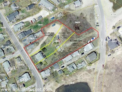
Nantucket CompLINK
LINK Listing Information Network
427 in this area
428 Total Sales


Estimated Value: $2,464,000 - $6,456,000
Not listed in LINK
some structures exist on property - but value is in land
Last Agent to Sell the Property
LINK Listing Information Network Listed on: 12/10/2013
| Date | Buyer | Sale Price | Title Company |
|---|---|---|---|
| Norwell Llc | $4,500,000 | -- |
| Date | Status | Borrower | Loan Amount |
|---|---|---|---|
| Previous Owner | Norwell Llc | $50,000 | |
| Previous Owner | Norwell Llc | $139,800 |
| Date | Event | Price | Change | Sq Ft Price |
|---|---|---|---|---|
| 12/10/2013 12/10/13 | Sold | $4,500,000 | -- | $2,574 / Sq Ft |
| Year | Tax Paid | Tax Assessment Tax Assessment Total Assessment is a certain percentage of the fair market value that is determined by local assessors to be the total taxable value of land and additions on the property. | Land | Improvement |
|---|---|---|---|---|
| 2025 | $4,316 | $1,315,800 | $1,315,800 | $0 |
| 2024 | $3,960 | $1,265,200 | $1,265,200 | $0 |
| 2023 | $3,559 | $1,108,600 | $1,108,600 | $0 |
| 2022 | $3,157 | $844,200 | $844,200 | $0 |
| 2021 | $2,919 | $804,000 | $804,000 | $0 |
| 2020 | $2,774 | $804,000 | $804,000 | $0 |
| 2019 | $2,695 | $802,000 | $802,000 | $0 |
| 2018 | $3,177 | $900,000 | $900,000 | $0 |
| 2017 | $9,577 | $2,825,000 | $2,825,000 | $0 |
| 2016 | $10,642 | $3,167,200 | $2,825,000 | $342,200 |
| 2015 | $4,086 | $3,203,600 | $2,715,000 | $488,600 |
| 2014 | $4,086 | $1,075,500 | $730,500 | $345,000 |
N
Seller's Agent in 2013
Nantucket CompLINK
LINK Listing Information Network
427 in this area
428 Total Sales
Source: LINK
MLS Number: 78609
APN: NANT-005-514-000-000-0000-72-000-000
