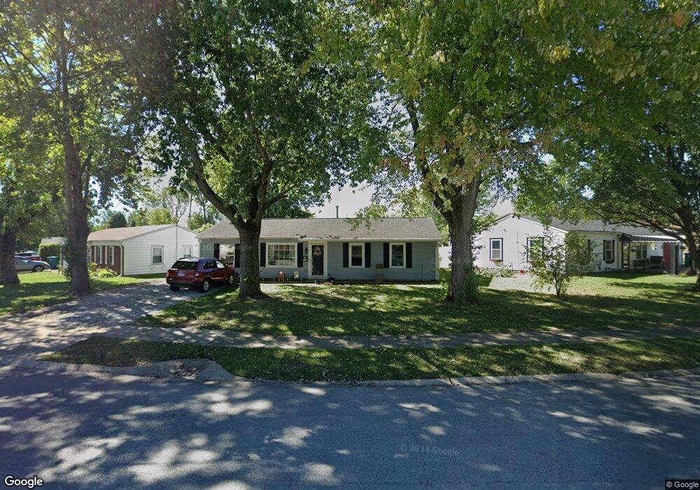
780 Maple Ln Mooresville, IN 46158
Estimated Value: $208,000 - $217,000
3
Beds
1
Bath
1,225
Sq Ft
$173/Sq Ft
Est. Value
About This Home
This home is located at 780 Maple Ln, Mooresville, IN 46158 and is currently estimated at $211,990, approximately $173 per square foot. 780 Maple Ln is a home located in Morgan County with nearby schools including Mooresville High School and Mooresville Christian Academy.
Ownership History
Date
Name
Owned For
Owner Type
Purchase Details
Closed on
Oct 17, 2016
Sold by
Sequoia Group Llc
Bought by
Huether Nicholas B and Huether Elisabeth J
Current Estimated Value
Home Financials for this Owner
Home Financials are based on the most recent Mortgage that was taken out on this home.
Original Mortgage
$113,110
Outstanding Balance
$90,736
Interest Rate
3.48%
Mortgage Type
New Conventional
Estimated Equity
$121,254
Purchase Details
Closed on
Apr 18, 2016
Sold by
Gilliam Rachel A
Bought by
Sequoia Group Llc
Purchase Details
Closed on
Nov 20, 2009
Sold by
Stewart Robert K and Stewart Shawn R
Bought by
Gilliam Rachel A
Home Financials for this Owner
Home Financials are based on the most recent Mortgage that was taken out on this home.
Original Mortgage
$80,580
Interest Rate
4.95%
Mortgage Type
New Conventional
Purchase Details
Closed on
Jun 30, 2009
Sold by
Lundy William R and Stewart Robert K
Bought by
Stewart Robert K and Stewart Shawn R
Purchase Details
Closed on
Mar 7, 2005
Sold by
Federal Home Loan Mortgage Corporation
Bought by
Lundy William R and Stewart Robert K
Create a Home Valuation Report for This Property
The Home Valuation Report is an in-depth analysis detailing your home's value as well as a comparison with similar homes in the area
Home Values in the Area
Average Home Value in this Area
Purchase History
| Date | Buyer | Sale Price | Title Company |
|---|---|---|---|
| Huether Nicholas B | -- | Chicago Title Company Llc | |
| Sequoia Group Llc | $63,901 | None Available | |
| Gilliam Rachel A | -- | -- | |
| Stewart Robert K | -- | None Available | |
| Lundy William R | -- | None Available |
Source: Public Records
Mortgage History
| Date | Status | Borrower | Loan Amount |
|---|---|---|---|
| Open | Huether Nicholas B | $113,110 | |
| Previous Owner | Gilliam Rachel A | $80,580 |
Source: Public Records
Tax History Compared to Growth
Tax History
| Year | Tax Paid | Tax Assessment Tax Assessment Total Assessment is a certain percentage of the fair market value that is determined by local assessors to be the total taxable value of land and additions on the property. | Land | Improvement |
|---|---|---|---|---|
| 2024 | $936 | $159,400 | $32,900 | $126,500 |
| 2023 | $877 | $159,400 | $32,900 | $126,500 |
| 2022 | $800 | $138,600 | $32,900 | $105,700 |
| 2021 | $620 | $120,300 | $18,200 | $102,100 |
| 2020 | $602 | $118,000 | $16,400 | $101,600 |
| 2019 | $466 | $101,900 | $16,400 | $85,500 |
| 2018 | $400 | $94,500 | $16,400 | $78,100 |
| 2017 | $388 | $93,300 | $16,400 | $76,900 |
| 2016 | $234 | $78,100 | $16,400 | $61,700 |
| 2014 | $150 | $72,700 | $16,400 | $56,300 |
| 2013 | $150 | $72,700 | $16,400 | $56,300 |
Source: Public Records
Map
Nearby Homes
- 91 North Dr
- 820 Morningstar Dr
- 150 Church St
- 91 Dunn Dr
- 321 Maple Ln
- 32 Raesta Dr
- 0 E Hadley Rd Unit MBR21956464
- 1037 Delwood Dr
- 167 Maple Ln
- 79 Circle Dr
- 1125 Delwood Dr
- 0 E Hendricks County Line Road Lot 2 Unit MBR22042067
- 540 S R 267
- 150 W Main St
- 124 S Indiana St
- 18 W High St
- 429 Conduitt Dr
- 113 W High St
- 320 Lockerbie St
- 0 N S R 67 Unit 21524933