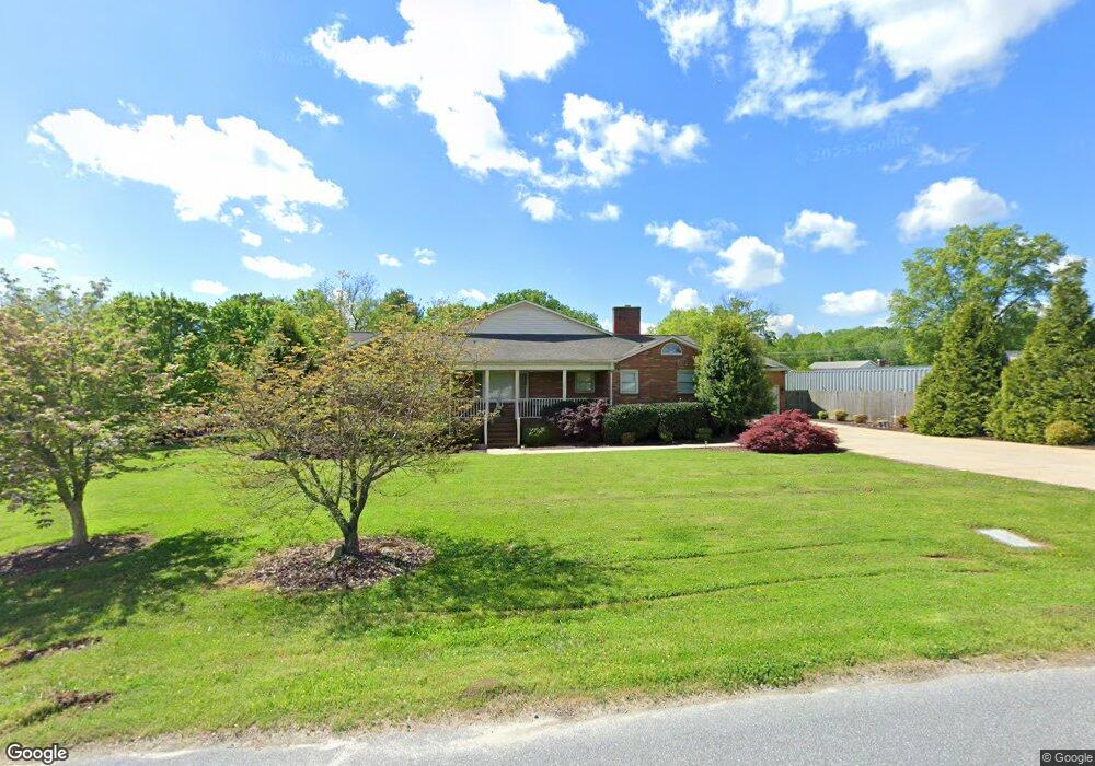
7800 Cherry Point Rd Denver, NC 28037
Estimated Value: $221,000 - $834,000
3
Beds
3
Baths
2,969
Sq Ft
$177/Sq Ft
Est. Value
About This Home
This home is located at 7800 Cherry Point Rd, Denver, NC 28037 and is currently estimated at $525,054, approximately $176 per square foot. 7800 Cherry Point Rd is a home located in Lincoln County with nearby schools including Catawba Springs Elementary School, East Lincoln Middle School, and East Lincoln High School.
Ownership History
Date
Name
Owned For
Owner Type
Purchase Details
Closed on
Aug 28, 2024
Sold by
Janice Darlene Morrell Revocable Living and Morrell Janice Darlene
Bought by
Land Billy Edward
Current Estimated Value
Purchase Details
Closed on
Apr 12, 2023
Sold by
Morrell Janice Darlene
Bought by
Janice Darlene Morrell Revocable Living Trust
Create a Home Valuation Report for This Property
The Home Valuation Report is an in-depth analysis detailing your home's value as well as a comparison with similar homes in the area
Purchase History
| Date | Buyer | Sale Price | Title Company |
|---|---|---|---|
| Land Billy Edward | $185,000 | None Listed On Document | |
| Janice Darlene Morrell Revocable Living Trust | -- | None Listed On Document |
Source: Public Records
Tax History
| Year | Tax Paid | Tax Assessment Tax Assessment Total Assessment is a certain percentage of the fair market value that is determined by local assessors to be the total taxable value of land and additions on the property. | Land | Improvement |
|---|---|---|---|---|
| 2025 | $2,253 | $349,888 | $85,267 | $264,621 |
| 2024 | $2,224 | $349,888 | $85,267 | $264,621 |
| 2023 | $2,224 | $349,888 | $85,267 | $264,621 |
| 2022 | $1,625 | $204,382 | $68,214 | $136,168 |
| 2021 | $1,636 | $204,382 | $68,214 | $136,168 |
| 2020 | $1,425 | $204,382 | $68,214 | $136,168 |
| 2019 | $1,425 | $204,382 | $68,214 | $136,168 |
| 2018 | $1,457 | $193,699 | $68,214 | $125,485 |
| 2017 | $1,356 | $193,699 | $68,214 | $125,485 |
| 2016 | $1,350 | $193,699 | $68,214 | $125,485 |
| 2015 | $1,469 | $193,699 | $68,214 | $125,485 |
| 2014 | $1,853 | $258,148 | $85,267 | $172,881 |
Source: Public Records
Map
Nearby Homes
- 8078 Blackwood Rd
- 6242 Ashton Park Dr
- 4222 Millstream Rd
- 913 Prince Garrett Way
- 4197 Millstream Rd
- 956 Prince Garrett Way
- 4178 Millstream Rd
- 4172 Millstream Rd Unit 137
- 4168 Millstream Rd
- 1855 Cameron Heights Cir
- 1374 Cedardale Ln
- 7755 Deer Track Dr
- 1751 Knights Dr
- TBD Forest Oak Dr Unit 63
- 1808 Cameron Heights Cir
- 7540 Deer Track Dr Unit 28
- 7958 Unity Church Rd
- 274/294 N Pilot Knob Rd
- 1984 Hickory Hills Dr
- 7380 Latham Way
- 7800 Cherry Point Dr
- 786 N Highway 16
- 774 N Nc 16 Business Hwy
- 7843 Lucky Creek Ln
- 756 N Nc 16 Business Hwy
- 7852 Cherry Point Rd
- 748 Nc 16 Hwy
- 748 N Highway 16
- 0000 Lucky Creek Ln
- 27 Lucky Creek Ln
- 19-19A Lucky Creek Ln
- 20-20A Lucky Creek Ln
- 21-21A Lucky Creek Ln
- 7 Lucky Creek Ln Unit 7
- 0 Lucky Creek Ln Unit 31 9597210
- 0 Lucky Creek Ln Unit 31
- 0 Lucky Creek Ln Unit 3608541
- 00 Lucky Creek Ln Unit 21, 21A
- 00 Lucky Creek Ln Unit 20, 20A
- 00 Lucky Creek Ln Unit 19, 19A
Your Personal Tour Guide
Ask me questions while you tour the home.