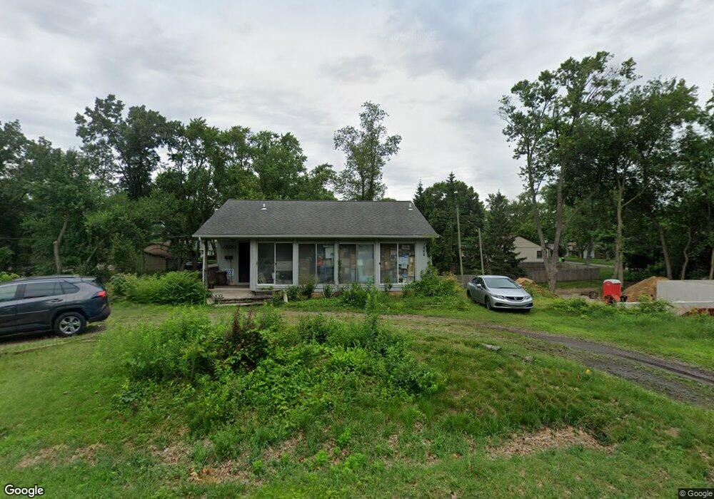
7800 Richardson Rd West Bloomfield, MI 48323
Estimated Value: $258,535 - $316,000
1
Bed
2
Baths
979
Sq Ft
$286/Sq Ft
Est. Value
About This Home
This home is located at 7800 Richardson Rd, West Bloomfield, MI 48323 and is currently estimated at $279,634, approximately $285 per square foot. 7800 Richardson Rd is a home located in Oakland County with nearby schools including Clifford H. Smart Middle School, Walled Lake Northern High School, and St. Matthew Lutheran School.
Ownership History
Date
Name
Owned For
Owner Type
Purchase Details
Closed on
Mar 1, 2024
Sold by
Anderson Ann M
Bought by
Anderson Ann Melba and Anderson Ross Stuart
Current Estimated Value
Home Financials for this Owner
Home Financials are based on the most recent Mortgage that was taken out on this home.
Original Mortgage
$315,000
Outstanding Balance
$310,172
Interest Rate
6.69%
Mortgage Type
Construction
Estimated Equity
-$30,538
Purchase Details
Closed on
Nov 9, 2017
Sold by
Anderson Ann M and Estate Of Kathleen Charlmers G
Bought by
Anderson Ann M and Giardina Ann M
Create a Home Valuation Report for This Property
The Home Valuation Report is an in-depth analysis detailing your home's value as well as a comparison with similar homes in the area
Home Values in the Area
Average Home Value in this Area
Purchase History
| Date | Buyer | Sale Price | Title Company |
|---|---|---|---|
| Anderson Ann Melba | -- | None Listed On Document | |
| Anderson Ann Melba | -- | None Listed On Document | |
| Anderson Ann M | -- | None Available |
Source: Public Records
Mortgage History
| Date | Status | Borrower | Loan Amount |
|---|---|---|---|
| Open | Anderson Ann Melba | $315,000 | |
| Closed | Anderson Ann Melba | $315,000 |
Source: Public Records
Tax History Compared to Growth
Tax History
| Year | Tax Paid | Tax Assessment Tax Assessment Total Assessment is a certain percentage of the fair market value that is determined by local assessors to be the total taxable value of land and additions on the property. | Land | Improvement |
|---|---|---|---|---|
| 2024 | $1,420 | $113,580 | $0 | $0 |
| 2022 | $1,618 | $104,920 | $38,980 | $65,940 |
| 2021 | $2,208 | $97,660 | $0 | $0 |
| 2020 | $1,323 | $96,630 | $38,980 | $57,650 |
| 2018 | $2,143 | $88,530 | $33,750 | $54,780 |
| 2015 | -- | $70,630 | $0 | $0 |
| 2014 | -- | $64,410 | $0 | $0 |
| 2011 | -- | $56,590 | $0 | $0 |
Source: Public Records
Map
Nearby Homes
- 7969 Richardson Rd
- 7381 Crestmore St
- 7337 Richardson Rd
- 4212 Greendale Ave
- 4245 Bunker Ave
- 7369 Sweetbriar
- 7359 Woodlore Dr
- 4335 Crestdale Ave
- 6978 Colony Dr
- 0000 Dickert St
- 6903 Dandison Blvd
- 7146 Arrowood Dr
- 3291 Melmoor St
- 3280 Chambourne St
- 1777 Addison Cir
- 1047 Addison Cir
- 8330 Dickert St
- 103 Addison Cir
- 3991 Fieldview Ave
- 8223 Arlis St
- 7806 Richardson Rd
- 3991 Beach Terrace
- 3979 Beach Terrace
- 7777 Richardson Rd
- 7803 Richardson Rd
- 3976 Beach Terrace
- 7816 Richardson Rd
- 3988 Oak Terrace
- 7760 Richardson Rd
- 7748 Richardson Rd
- 7815 Richardson Rd
- 3967 Beach Terrace
- 3965 Maple Blvd
- 4036 Circle Blvd
- 7759 Richardson Rd
- 3931 Maple Blvd
- 4039 Circle Blvd
- 3960 Oak Terrace
- 3995 Oak Terrace
- 4039 Circle Bvld