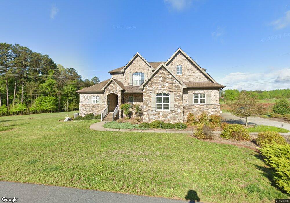
7801 St Andrews Ln Stanley, NC 28164
Estimated Value: $710,000 - $835,000
4
Beds
4
Baths
2,857
Sq Ft
$267/Sq Ft
Est. Value
About This Home
This home is located at 7801 St Andrews Ln, Stanley, NC 28164 and is currently estimated at $762,693, approximately $266 per square foot. 7801 St Andrews Ln is a home with nearby schools including Catawba Springs Elementary School, East Lincoln Middle School, and East Lincoln High School.
Ownership History
Date
Name
Owned For
Owner Type
Purchase Details
Closed on
Oct 16, 2023
Sold by
Breath Ashleigh
Bought by
Breath Kenneth
Current Estimated Value
Purchase Details
Closed on
Oct 30, 2014
Sold by
Mundy James A and Mundy Frances S
Bought by
Breath Kenneth and Breath Ashleigh
Purchase Details
Closed on
May 8, 2006
Sold by
The Denver Group Llc
Bought by
Mundy James A and Mundy Frances S
Create a Home Valuation Report for This Property
The Home Valuation Report is an in-depth analysis detailing your home's value as well as a comparison with similar homes in the area
Home Values in the Area
Average Home Value in this Area
Purchase History
| Date | Buyer | Sale Price | Title Company |
|---|---|---|---|
| Breath Kenneth | -- | None Listed On Document | |
| Breath Kenneth | -- | None Listed On Document | |
| Breath Kenneth | $42,000 | None Available | |
| Mundy James A | $65,000 | None Available |
Source: Public Records
Tax History Compared to Growth
Tax History
| Year | Tax Paid | Tax Assessment Tax Assessment Total Assessment is a certain percentage of the fair market value that is determined by local assessors to be the total taxable value of land and additions on the property. | Land | Improvement |
|---|---|---|---|---|
| 2025 | $3,936 | $628,492 | $88,220 | $540,272 |
| 2024 | $3,900 | $628,492 | $88,220 | $540,272 |
| 2023 | $3,895 | $628,492 | $88,220 | $540,272 |
| 2022 | $3,267 | $426,456 | $70,174 | $356,282 |
| 2021 | $3,288 | $426,456 | $70,174 | $356,282 |
| 2020 | $2,972 | $426,456 | $70,174 | $356,282 |
| 2019 | $2,972 | $426,456 | $70,174 | $356,282 |
| 2018 | $2,528 | $346,658 | $48,882 | $297,776 |
| 2017 | $2,427 | $346,658 | $48,882 | $297,776 |
| 2016 | $1,852 | $0 | $48,882 | $216,825 |
| 2015 | $288 | $40,382 | $40,382 | $0 |
| 2014 | -- | $23,250 | $23,250 | $0 |
Source: Public Records
Map
Nearby Homes
- 7791 Oak Haven Ln
- 7809 Oak Haven Ln
- 7768 Burning Ridge Dr
- 7738 Burning Ridge Dr
- 7884 Oak Haven Ln
- Lot #43 Lytham Ln
- 802 Seipel Dr
- 7736 Turnberry Ln
- 128 Killian Farm Rd
- 8030 Ravenwood Ln
- 7967 Glen Abbey Cir
- 7919 Glen Abbey Cir
- 274/294 N Pilot Knob Rd
- 2227 Caravan Ln
- McDowell Plan at Carrington
- Davidson Plan at Carrington
- Drexel Plan at Carrington
- Mayfair Plan at Carrington
- Wescott Plan at Carrington
- Edgefield Plan at Carrington
- 7796 Saint Andrews Ln
- 7796 St Andrews Ln
- 7818 Saint Andrews Ln
- 7790 Saint Andrews Ln
- 7784 Saint Andrews Ln
- 7824 St Andrews Ln
- 7824 Saint Andrews Ln
- 7767 Saint Andrews Ln
- 7776 Saint Andrews Ln
- 7768 Saint Andrews Ln
- 7757 Saint Andrews Ln
- 7757 Lone St
- L14&15 St Andrews Ln
- L14/15 Saint Andrews Ln Unit Lot 14&15
- 7830 Saint Andrews Ln
- 7756 Saint Andrews Ln
- 7755 Saint Andrews Ln
- 7855 St Andrews Ln
- 7783 Oak Haven Ln
- 7787 Oak Haven Ln