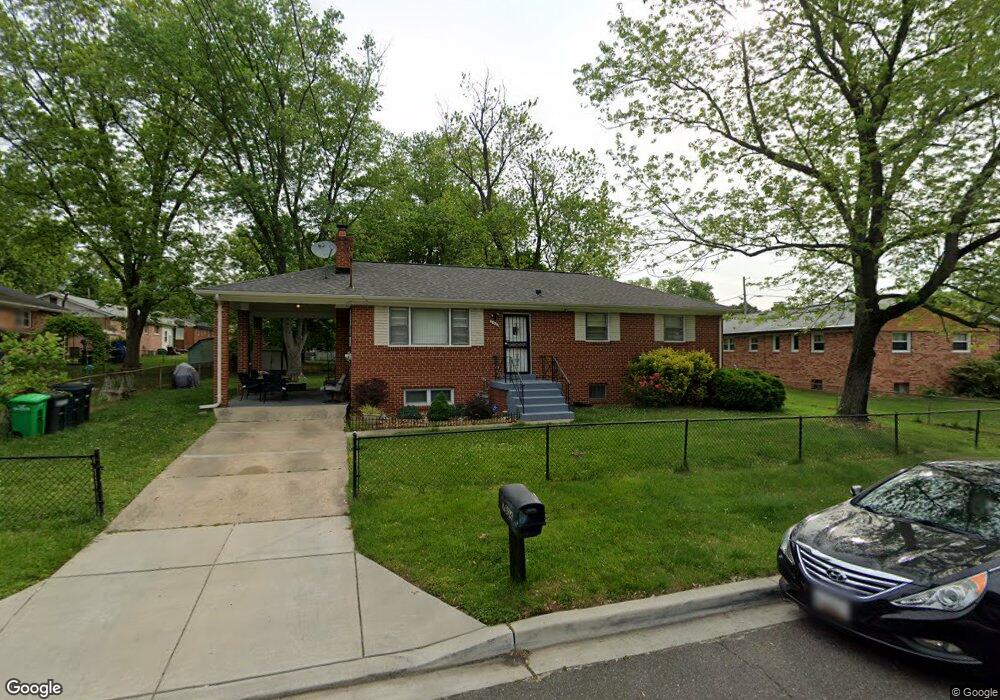
7804 Denton Dr Clinton, MD 20735
Estimated Value: $308,000 - $414,000
Studio
2
Baths
1,125
Sq Ft
$336/Sq Ft
Est. Value
About This Home
This home is located at 7804 Denton Dr, Clinton, MD 20735 and is currently estimated at $378,206, approximately $336 per square foot. 7804 Denton Dr is a home located in Prince George's County with nearby schools including Francis T. Evans Elementary School, Stephen Decatur Middle School, and Dr. Henry A. Wise Jr. High School.
Ownership History
Date
Name
Owned For
Owner Type
Purchase Details
Closed on
Dec 13, 2004
Sold by
Mcgill Anthony C
Bought by
Jones Gina
Current Estimated Value
Purchase Details
Closed on
Mar 31, 2000
Sold by
Taylor Richard
Bought by
Mcgill Anthony C
Purchase Details
Closed on
Nov 18, 1993
Sold by
Feddiman S
Bought by
Taylor Richard
Home Financials for this Owner
Home Financials are based on the most recent Mortgage that was taken out on this home.
Original Mortgage
$124,600
Interest Rate
6.77%
Create a Home Valuation Report for This Property
The Home Valuation Report is an in-depth analysis detailing your home's value as well as a comparison with similar homes in the area
Home Values in the Area
Average Home Value in this Area
Purchase History
| Date | Buyer | Sale Price | Title Company |
|---|---|---|---|
| Jones Gina | $220,000 | -- | |
| Mcgill Anthony C | $150,000 | -- | |
| Taylor Richard | $128,600 | -- |
Source: Public Records
Mortgage History
| Date | Status | Borrower | Loan Amount |
|---|---|---|---|
| Previous Owner | Taylor Richard | $124,600 |
Source: Public Records
Tax History
| Year | Tax Paid | Tax Assessment Tax Assessment Total Assessment is a certain percentage of the fair market value that is determined by local assessors to be the total taxable value of land and additions on the property. | Land | Improvement |
|---|---|---|---|---|
| 2025 | $4,967 | $322,700 | $101,200 | $221,500 |
| 2024 | $4,967 | $307,400 | -- | -- |
| 2023 | $4,738 | $292,100 | $0 | $0 |
| 2022 | $4,511 | $276,800 | $101,200 | $175,600 |
| 2021 | $4,297 | $262,367 | $0 | $0 |
| 2020 | $4,082 | $247,933 | $0 | $0 |
| 2019 | $3,868 | $233,500 | $100,600 | $132,900 |
| 2018 | $3,736 | $224,633 | $0 | $0 |
| 2017 | $3,604 | $215,767 | $0 | $0 |
| 2016 | -- | $206,900 | $0 | $0 |
| 2015 | $2,931 | $204,667 | $0 | $0 |
| 2014 | $2,931 | $202,433 | $0 | $0 |
Source: Public Records
Map
Nearby Homes
- 8719 Brazke Ct
- 7705 Old Alexandria Ferry Rd
- 0 Dangerfield Rd
- 7804 New Ascot Ln
- 7105 Friendship Rd
- 7502 Milligan Ln
- 7209 Mcmillen Dr
- 7205 Mcmillen Dr
- 10104 Dangerfield Rd
- 8518 Cedar Chase Dr
- 9602 Stuart Ln
- 9200 Pine View Ln
- 8805 Mimosa Ave
- 7811 Heflin Dr
- 9401 Cheltenham Ave
- 9613 Quiet Brook Ln
- 9004 Eldon Dr
- 9003 Woodyard Rd
- 8108 Sonar Rd
- 9104 Rama Ct
- 7800 Wynnwood Dr
- 8420 Woodyard Rd
- 8418 Woodyard Rd
- 7804 Wynnwood Dr
- 7801 Denton Dr
- 8416 Woodyard Rd
- 7808 Wynnwood Dr
- 7809 Denton Dr
- 7801 Wynnwood Dr
- 7805 Wynnwood Dr
- 8414 Woodyard Rd
- 7812 Wynnwood Dr
- 7813 Denton Dr
- 8511 Woodyard Rd
- 8504 Woodyard Rd
- 7809 Wynnwood Dr
- 7826 Denton Dr
- 7817 Denton Dr
- 8412 Woodyard Rd
Your Personal Tour Guide
Ask me questions while you tour the home.