Estimated Value: $139,228 - $277,000
--
Bed
1
Bath
1,050
Sq Ft
$204/Sq Ft
Est. Value
About This Home
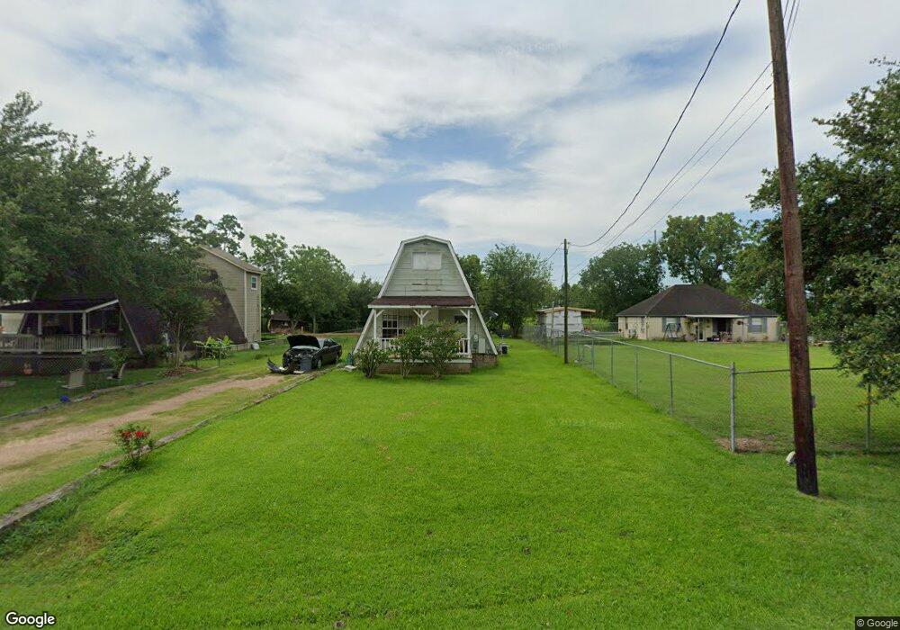
This home is located at 781 County Road 296, Alvin, TX 77511 and is currently estimated at $214,307, approximately $204 per square foot. 781 County Road 296 is a home with nearby schools including Mark Twain Elementary School, G.W. Harby Junior High School, and Alvin High School.
Ownership History
Date
Name
Owned For
Owner Type
Purchase Details
Closed on
Jul 6, 2011
Sold by
Federal Home Loan Mortgage Corporation
Bought by
Coker Roger
Current Estimated Value
Purchase Details
Closed on
Mar 1, 2011
Sold by
Mach Thomas Edward
Bought by
Federal Home Loan Mortgage Corp
Purchase Details
Closed on
Apr 22, 2006
Sold by
Hively Robert A
Bought by
Mach Thomas Edward
Home Financials for this Owner
Home Financials are based on the most recent Mortgage that was taken out on this home.
Original Mortgage
$61,400
Interest Rate
6.33%
Mortgage Type
Fannie Mae Freddie Mac
Create a Home Valuation Report for This Property
The Home Valuation Report is an in-depth analysis detailing your home's value as well as a comparison with similar homes in the area
Home Values in the Area
Average Home Value in this Area
Purchase History
| Date | Buyer | Sale Price | Title Company |
|---|---|---|---|
| Coker Roger | -- | Chicago Title | |
| Federal Home Loan Mortgage Corp | $62,761 | None Available | |
| Mach Thomas Edward | -- | Stewart Title Brazoria |
Source: Public Records
Mortgage History
| Date | Status | Borrower | Loan Amount |
|---|---|---|---|
| Previous Owner | Mach Thomas Edward | $61,400 |
Source: Public Records
Tax History Compared to Growth
Tax History
| Year | Tax Paid | Tax Assessment Tax Assessment Total Assessment is a certain percentage of the fair market value that is determined by local assessors to be the total taxable value of land and additions on the property. | Land | Improvement |
|---|---|---|---|---|
| 2025 | $1,495 | $80,000 | $48,000 | $32,000 |
| 2023 | $1,495 | $80,000 | $48,000 | $32,000 |
| 2022 | $2,012 | $71,500 | $42,000 | $29,500 |
| 2021 | $1,509 | $67,980 | $26,000 | $41,980 |
| 2020 | $1,237 | $55,000 | $20,000 | $35,000 |
| 2019 | $1,233 | $53,280 | $7,200 | $46,080 |
| 2018 | $1,237 | $53,280 | $7,200 | $46,080 |
| 2017 | $1,057 | $45,000 | $6,900 | $38,100 |
| 2016 | $1,149 | $48,910 | $7,200 | $41,710 |
| 2015 | $899 | $43,340 | $6,000 | $37,340 |
| 2014 | $899 | $38,000 | $6,000 | $32,000 |
Source: Public Records
Map
Nearby Homes
- 432 Kendall Crest Dr
- 424 Kendall Crest Dr
- 415 Kendall Crest Dr
- 406 Kendall Crest Dr
- 431 Kendall Crest Dr
- 397 Kendall Crest Dr
- 418 Kendall Crest Dr
- 414 Kendall Crest Dr
- 404 Kendall Crest Dr
- 390 Kendall Crest Dr
- 396 Kendall Crest Dr
- 394 Kendall Crest Dr
- 380 Kendall Crest Dr
- 368 Selah Ct
- 726 Rim Water Dr
- 356 Selah Ct
- 4738 Alluvial Cir
- 350 Selah Ct
- 4724 Alluvial Cir
- 340 Kendall Crest Dr
- 781 Cline Ln
- 799 Cline Ln Cr 296
- 799 County Road 296
- 765 County Road 296
- 799 Cr 296
- 761 County Road 296
- 717 County Road 296
- 781 County Road 296d
- 781 Cr 296d
- 655 County Road 296
- 155 County Road 296c
- 656 Cline Dr
- 656 County Road 296 Unit 296
- 188 County Road 296c
- 187 County Road 296c
- 456 Lake Line Dr
- 430 Kendall Crest Dr
- 792 County Rd
- 638 County Road 296
- 659 County Road 296d