Estimated Value: $166,285 - $207,000
3
Beds
1
Bath
1,872
Sq Ft
$99/Sq Ft
Est. Value
About This Home
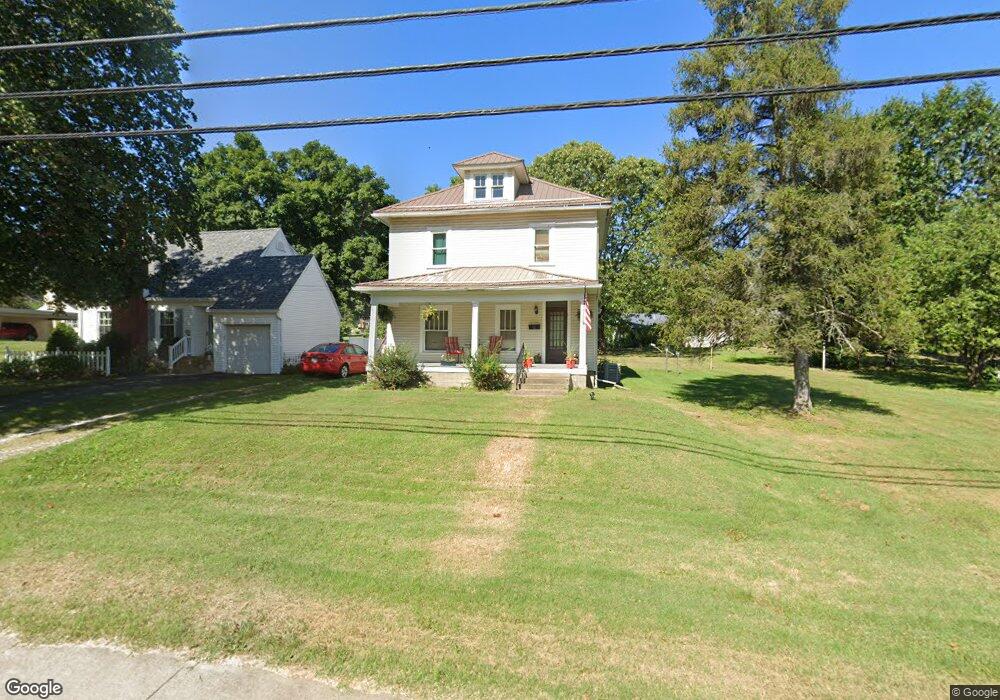
This home is located at 781 Walhonding Ave, Logan, OH 43138 and is currently estimated at $186,071, approximately $99 per square foot. 781 Walhonding Ave is a home located in Hocking County with nearby schools including Central Elementary School, Logan Christian School, and St. John the Evangelist School.
Ownership History
Date
Name
Owned For
Owner Type
Purchase Details
Closed on
Mar 26, 2017
Current Estimated Value
Home Financials for this Owner
Home Financials are based on the most recent Mortgage that was taken out on this home.
Interest Rate
4.23%
Purchase Details
Closed on
Mar 16, 2017
Home Financials for this Owner
Home Financials are based on the most recent Mortgage that was taken out on this home.
Interest Rate
4.23%
Purchase Details
Closed on
Mar 12, 2017
Home Financials for this Owner
Home Financials are based on the most recent Mortgage that was taken out on this home.
Interest Rate
4.23%
Create a Home Valuation Report for This Property
The Home Valuation Report is an in-depth analysis detailing your home's value as well as a comparison with similar homes in the area
Home Values in the Area
Average Home Value in this Area
Purchase History
| Date | Buyer | Sale Price | Title Company |
|---|---|---|---|
| -- | $73,000 | -- | |
| -- | $73,000 | -- | |
| -- | $73,000 | -- |
Source: Public Records
Mortgage History
| Date | Status | Borrower | Loan Amount |
|---|---|---|---|
| Closed | -- | -- | |
| Closed | -- | -- | |
| Closed | -- | -- |
Source: Public Records
Tax History Compared to Growth
Tax History
| Year | Tax Paid | Tax Assessment Tax Assessment Total Assessment is a certain percentage of the fair market value that is determined by local assessors to be the total taxable value of land and additions on the property. | Land | Improvement |
|---|---|---|---|---|
| 2024 | $1,575 | $39,030 | $7,670 | $31,360 |
| 2023 | $1,575 | $39,030 | $7,670 | $31,360 |
| 2022 | $1,578 | $39,030 | $7,670 | $31,360 |
| 2021 | $1,330 | $30,490 | $6,140 | $24,350 |
| 2020 | $1,330 | $30,490 | $6,140 | $24,350 |
| 2019 | $1,331 | $30,490 | $6,140 | $24,350 |
| 2018 | $1,270 | $29,600 | $5,250 | $24,350 |
| 2017 | $1,198 | $29,600 | $5,250 | $24,350 |
| 2016 | $1,190 | $29,600 | $5,250 | $24,350 |
| 2015 | $801 | $19,210 | $4,820 | $14,390 |
| 2014 | $801 | $19,210 | $4,820 | $14,390 |
| 2013 | $805 | $19,210 | $4,820 | $14,390 |
Source: Public Records
Map
Nearby Homes
- 875 Walhonding Ave
- 743 Summit Dr
- 787 Huntley Ave
- 741 Huntley Ave
- 953 Marla Ave
- 28583 Hawthorne Way
- 806 Hobart Ave
- 928 Elizabeth Ave
- 67 W Front St
- State Route 328
- 0 County Rd 7 Unit 5156538
- 565 E Main St
- 571 E Main St
- 586 E Main St
- 598 E Main St
- 156 Zanesville Ave
- 714 E 2nd St
- 32366 Lilac Ln
- 32268 Cedar Ln
- 33 Furnace St
- 797 Walhonding Ave
- 850 Wyandotte Ave
- 755 Walhonding Ave
- 801 Baird St
- 861 Wyandotte Ave
- 0 Walhonding Ave
- 790 Wyandotte Ave
- 813 Walhonding Ave
- 733 Walhonding Ave
- 780 Walhonding Ave
- 820 Baird St
- 825 Walhonding Ave
- 750 Walhonding Ave
- 770 Wyandotte Ave
- 840 Baird St
- 851 Baird St
- 720 Walhonding Ave
- 790 Walhonding Ave
- 11 Wilson Ave
- 23 Wilson Ave