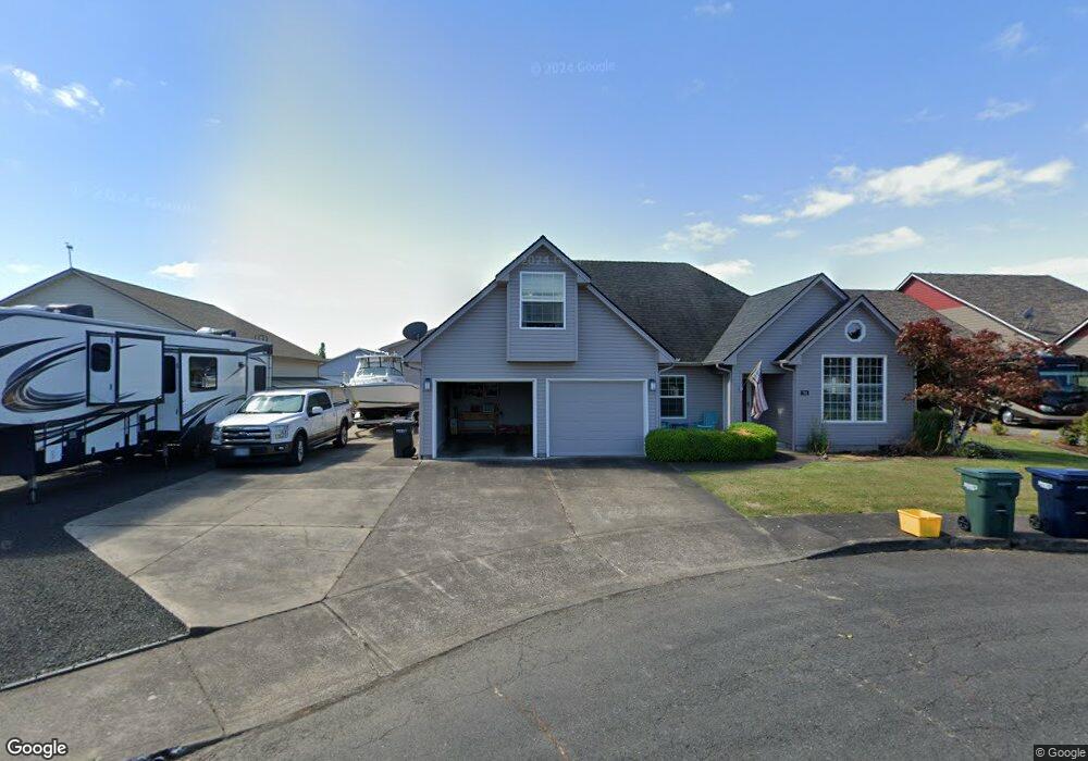
783 Piper St Independence, OR 97351
Estimated Value: $760,000 - $801,000
3
Beds
3
Baths
2,585
Sq Ft
$302/Sq Ft
Est. Value
About This Home
This home is located at 783 Piper St, Independence, OR 97351 and is currently estimated at $780,603, approximately $301 per square foot. 783 Piper St is a home located in Polk County with nearby schools including Independence Elementary School, Talmadge Middle School, and Central High School.
Ownership History
Date
Name
Owned For
Owner Type
Purchase Details
Closed on
Jul 6, 2022
Sold by
Michael P And Deborah J Kelley Living Tr
Bought by
Ungerecht Living Trust
Current Estimated Value
Purchase Details
Closed on
Mar 26, 2021
Sold by
Kelley Michael P and Kelley Deborah J
Bought by
Kelley Michael P and Kelley Deborah J
Purchase Details
Closed on
Dec 30, 2020
Sold by
Kelley Michael P and Kelley Deborah J
Bought by
Michael P Kelley And Deborah J Kelley Living and Kelley
Home Financials for this Owner
Home Financials are based on the most recent Mortgage that was taken out on this home.
Original Mortgage
$185,500
Interest Rate
3%
Mortgage Type
New Conventional
Purchase Details
Closed on
Jun 26, 2015
Sold by
Tolle Alan E and Tolle Diana L
Bought by
Michael P & Deborah J Kelley Living Trus and Kelley Deborah J
Purchase Details
Closed on
Dec 29, 2005
Sold by
Francke A Dolores
Bought by
Tolle Alan E and Tolle Diana L
Create a Home Valuation Report for This Property
The Home Valuation Report is an in-depth analysis detailing your home's value as well as a comparison with similar homes in the area
Home Values in the Area
Average Home Value in this Area
Purchase History
| Date | Buyer | Sale Price | Title Company |
|---|---|---|---|
| Ungerecht Living Trust | $775,000 | First American Title | |
| Kelley Michael P | -- | Amrock Llc | |
| Michael P Kelley And Deborah J Kelley Living | -- | None Listed On Document | |
| Kelley Michael P | -- | None Listed On Document | |
| Michael P & Deborah J Kelley Living Trus | $335,000 | First American Title | |
| Tolle Alan E | $350,000 | Ticor Title |
Source: Public Records
Mortgage History
| Date | Status | Borrower | Loan Amount |
|---|---|---|---|
| Previous Owner | Kelley Michael P | $185,500 |
Source: Public Records
Tax History Compared to Growth
Tax History
| Year | Tax Paid | Tax Assessment Tax Assessment Total Assessment is a certain percentage of the fair market value that is determined by local assessors to be the total taxable value of land and additions on the property. | Land | Improvement |
|---|---|---|---|---|
| 2025 | $7,186 | $408,620 | $60,270 | $348,350 |
| 2024 | $7,186 | $396,720 | $58,510 | $338,210 |
| 2023 | $7,370 | $385,170 | $56,810 | $328,360 |
| 2022 | $6,766 | $373,960 | $55,150 | $318,810 |
| 2021 | $6,690 | $363,070 | $53,540 | $309,530 |
| 2020 | $6,516 | $352,500 | $51,980 | $300,520 |
| 2019 | $6,346 | $342,240 | $50,470 | $291,770 |
| 2018 | $6,144 | $332,280 | $49,000 | $283,280 |
| 2017 | $6,110 | $322,610 | $47,580 | $275,030 |
| 2016 | $6,025 | $308,910 | $98,000 | $210,910 |
| 2015 | $6,159 | $313,220 | $46,190 | $267,030 |
| 2014 | $5,996 | $304,100 | $44,840 | $259,260 |
Source: Public Records
Map
Nearby Homes
- 914 James St
- 941 Wild Rose Ct
- 8575 Hoffman Rd
- 215 Polk St
- 1026 Sassafras St
- 212 Picture St
- 552 Log Cabin St
- 1361 Marigold Dr
- 470 N Gun Club Rd
- 320 N Gun Club Rd
- 250 N Gun Club Rd
- 488 B St
- 1555 Adams St
- 544 C St
- 1220 Monmouth (Unit 12) St
- 89 S Gun Club Rd
- 389 C St
- 144 S Main St
- 1686 Wilson Ct
- 950 D St