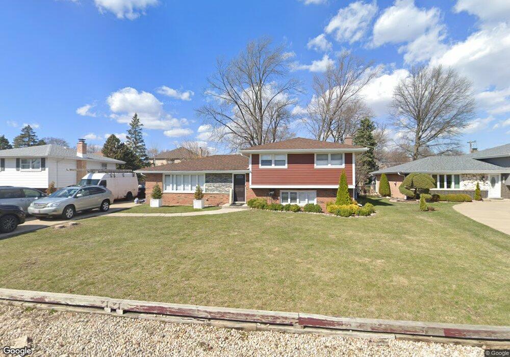
7846 W 99th Place Palos Hills, IL 60465
Estimated Value: $306,000 - $389,000
3
Beds
2
Baths
1,361
Sq Ft
$265/Sq Ft
Est. Value
About This Home
This home is located at 7846 W 99th Place, Palos Hills, IL 60465 and is currently estimated at $361,265, approximately $265 per square foot. 7846 W 99th Place is a home located in Cook County with nearby schools including Sorrick Elementary School, Oak Ridge Elementary School, and H H Conrady Jr High School.
Ownership History
Date
Name
Owned For
Owner Type
Purchase Details
Closed on
Feb 29, 2004
Sold by
Maso Joseph A and Maso Jeannie M
Bought by
Kowal Rafal
Current Estimated Value
Home Financials for this Owner
Home Financials are based on the most recent Mortgage that was taken out on this home.
Original Mortgage
$208,000
Outstanding Balance
$89,191
Interest Rate
4.5%
Mortgage Type
Unknown
Estimated Equity
$272,074
Purchase Details
Closed on
Dec 1, 1997
Sold by
Maxson Frank A and Maxson Patricia A
Bought by
Maso Joseph A and Maso Jeannie M
Home Financials for this Owner
Home Financials are based on the most recent Mortgage that was taken out on this home.
Original Mortgage
$132,000
Interest Rate
6.05%
Create a Home Valuation Report for This Property
The Home Valuation Report is an in-depth analysis detailing your home's value as well as a comparison with similar homes in the area
Home Values in the Area
Average Home Value in this Area
Purchase History
| Date | Buyer | Sale Price | Title Company |
|---|---|---|---|
| Kowal Rafal | $260,000 | Lawyers | |
| Maso Joseph A | $165,000 | Lawyers Title Insurance Corp |
Source: Public Records
Mortgage History
| Date | Status | Borrower | Loan Amount |
|---|---|---|---|
| Open | Kowal Rafal | $208,000 | |
| Previous Owner | Maso Joseph A | $132,000 |
Source: Public Records
Tax History Compared to Growth
Tax History
| Year | Tax Paid | Tax Assessment Tax Assessment Total Assessment is a certain percentage of the fair market value that is determined by local assessors to be the total taxable value of land and additions on the property. | Land | Improvement |
|---|---|---|---|---|
| 2024 | $7,133 | $28,000 | $7,817 | $20,183 |
| 2023 | $6,204 | $28,000 | $7,817 | $20,183 |
| 2022 | $6,204 | $20,425 | $6,809 | $13,616 |
| 2021 | $6,044 | $20,423 | $6,808 | $13,615 |
| 2020 | $5,996 | $20,423 | $6,808 | $13,615 |
| 2019 | $6,975 | $23,662 | $6,304 | $17,358 |
| 2018 | $6,713 | $23,662 | $6,304 | $17,358 |
| 2017 | $6,494 | $23,662 | $6,304 | $17,358 |
| 2016 | $6,508 | $21,336 | $5,547 | $15,789 |
| 2015 | $6,374 | $21,336 | $5,547 | $15,789 |
| 2014 | $6,278 | $21,336 | $5,547 | $15,789 |
| 2013 | $6,235 | $22,524 | $5,547 | $16,977 |
Source: Public Records
Map
Nearby Homes
- 7822 W 99th Place
- 7826 W 98th Place
- 7810 W 102nd St
- 9719 S 81st Ave
- 9901 S 76th Ave
- 10125 S 81st Ct
- 10226 S 81st Ave
- 10300 S Kathy Ct
- 10225 Camden Ln Unit K
- 10324 S 81st Ave
- 10233 Concord Ln Unit C
- 9417 S 78th Ave
- 9940 S Wood Ln
- 9407 S Roberts Rd Unit 3SE
- 8360 W 100th Place
- 10409 Sheffield Dr Unit 13
- 10221 S Eleanor Ave
- 9405 S 76th Ct
- 10440 S 75th Ct
- 9950 S 84th Terrace Unit 215
- 7838 W 99th Place
- 7854 W 99th Place
- 7835 W 99th St
- 7841 W 99th St
- 7862 W 99th Place
- 7825 W 99th St
- 7845 W 99th Place
- 7803 W 99th St
- 7847 W 99th St
- 7901 W 99th Place
- 7837 W 99th Place
- 7904 W 99th Place
- 7907 W 99th Place
- 7829 W 99th Place
- 7901 W 99th St
- 7911 W 99th Place
- 7821 W 99th Place
- 7808 W 99th Place
- 7912 W 99th Place
- 7846 W 100th St