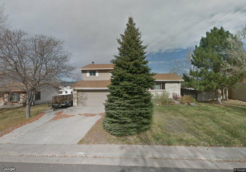
785 Mercury Cir Lone Tree, CO 80124
Estimated Value: $558,000 - $566,281
3
Beds
3
Baths
2,280
Sq Ft
$247/Sq Ft
Est. Value
About This Home
This home is located at 785 Mercury Cir, Lone Tree, CO 80124 and is currently estimated at $562,141, approximately $246 per square foot. 785 Mercury Cir is a home located in Douglas County with nearby schools including Acres Green Elementary School, Cresthill Middle School, and Highlands Ranch High School.
Ownership History
Date
Name
Owned For
Owner Type
Purchase Details
Closed on
May 10, 2012
Sold by
Arroyo Michele L
Bought by
Johnson Paul H
Current Estimated Value
Home Financials for this Owner
Home Financials are based on the most recent Mortgage that was taken out on this home.
Original Mortgage
$230,400
Outstanding Balance
$160,528
Interest Rate
4.02%
Mortgage Type
VA
Estimated Equity
$401,613
Purchase Details
Closed on
May 24, 2006
Sold by
Kyner Ward A
Bought by
Arroyo Michele L
Home Financials for this Owner
Home Financials are based on the most recent Mortgage that was taken out on this home.
Original Mortgage
$209,900
Interest Rate
6.5%
Mortgage Type
Fannie Mae Freddie Mac
Purchase Details
Closed on
Feb 3, 2002
Sold by
Kyner Ward A and Kyner Mary Beth
Bought by
Kyner Ward A
Purchase Details
Closed on
Oct 25, 2001
Sold by
Kyner David A and Kyner Sandra K
Bought by
Kyner Mary Beth and Kyner Ward A
Home Financials for this Owner
Home Financials are based on the most recent Mortgage that was taken out on this home.
Original Mortgage
$189,805
Interest Rate
6.71%
Purchase Details
Closed on
Aug 24, 1998
Sold by
Kyner Sandra K and Kyner David E
Bought by
Kyner Sandra K and Kyner David A
Home Financials for this Owner
Home Financials are based on the most recent Mortgage that was taken out on this home.
Original Mortgage
$130,368
Interest Rate
6.94%
Mortgage Type
FHA
Purchase Details
Closed on
Apr 30, 1998
Sold by
Laforcarde Jacqueline A and Laforcarde Tony A
Bought by
Kyner Sandra K and Kyner David A
Purchase Details
Closed on
Apr 14, 1998
Sold by
Laforcarde Lillian
Bought by
Laforcarde Jacqueline A
Purchase Details
Closed on
Apr 11, 1989
Sold by
Us Dept Housing & Urban Dev
Bought by
Laforcarde Jacqueline A and Laforcarde La Forcarde
Purchase Details
Closed on
Jul 29, 1988
Sold by
Public Trustee
Bought by
Fleet Mtg Corp
Purchase Details
Closed on
Mar 20, 1986
Sold by
Mc Master Arthur W & Ms Master Theresa C
Bought by
Stump Michael L and Stump Veronica B
Purchase Details
Closed on
May 10, 1985
Sold by
Pierson Miles G and Pierson Phyllis A
Bought by
Mc Master Arthur W & Theresa C
Purchase Details
Closed on
Apr 11, 1980
Sold by
Unavailable
Bought by
Unavailable
Create a Home Valuation Report for This Property
The Home Valuation Report is an in-depth analysis detailing your home's value as well as a comparison with similar homes in the area
Home Values in the Area
Average Home Value in this Area
Purchase History
| Date | Buyer | Sale Price | Title Company |
|---|---|---|---|
| Johnson Paul H | $225,000 | Meridian Title & Escrow Llc | |
| Arroyo Michele L | $262,400 | Fahtco | |
| Kyner Ward A | -- | -- | |
| Kyner Mary Beth | -- | -- | |
| Kyner Sandra K | -- | Title Services | |
| Kyner Sandra K | $150,000 | -- | |
| Laforcarde Jacqueline A | -- | -- | |
| Laforcarde Jacqueline A | -- | -- | |
| Fleet Mtg Corp | -- | -- | |
| Stump Michael L | $98,900 | -- | |
| Mc Master Arthur W & Theresa C | $95,000 | -- | |
| Unavailable | $71,400 | -- |
Source: Public Records
Mortgage History
| Date | Status | Borrower | Loan Amount |
|---|---|---|---|
| Open | Johnson Paul H | $230,400 | |
| Previous Owner | Arroyo Michele L | $209,900 | |
| Previous Owner | Kyner Mary Beth | $189,805 | |
| Previous Owner | Kyner Sandra K | $130,368 |
Source: Public Records
Tax History Compared to Growth
Tax History
| Year | Tax Paid | Tax Assessment Tax Assessment Total Assessment is a certain percentage of the fair market value that is determined by local assessors to be the total taxable value of land and additions on the property. | Land | Improvement |
|---|---|---|---|---|
| 2024 | $3,621 | $38,850 | $7,930 | $30,920 |
| 2023 | $3,736 | $38,850 | $7,930 | $30,920 |
| 2022 | $2,761 | $27,200 | $6,730 | $20,470 |
| 2021 | $2,852 | $27,200 | $6,730 | $20,470 |
| 2020 | $2,725 | $26,690 | $6,350 | $20,340 |
| 2019 | $2,763 | $26,690 | $6,350 | $20,340 |
| 2018 | $2,250 | $22,540 | $5,530 | $17,010 |
| 2017 | $2,274 | $22,540 | $5,530 | $17,010 |
| 2016 | $2,063 | $19,670 | $3,890 | $15,780 |
| 2015 | $2,100 | $19,670 | $3,890 | $15,780 |
| 2014 | $1,899 | $16,680 | $3,980 | $12,700 |
Source: Public Records
Map
Nearby Homes
- 789 Hamal Dr
- 979 Mercury Cir
- 7971 Arrowhead Ct
- 9275 Erminedale Dr
- 13134 Deneb Dr
- 7804 Silverweed Way
- 8049 Sweet Water Rd
- 9416 Kemper Dr
- 7057 Chestnut Hill St
- 202 Helena Cir
- 8159 Lodgepole Trail
- 9412 La Quinta Way
- 7151 Palisade Dr
- 7404 La Quinta Ln
- 7041 Chestnut Hill Trail
- 7107 Mountain Brush Cir
- 426 Jupiter Dr
- 8176 Lone Oak Ct
- 8260 Lodgepole Trail
- 9308 Miles Dr Unit 5