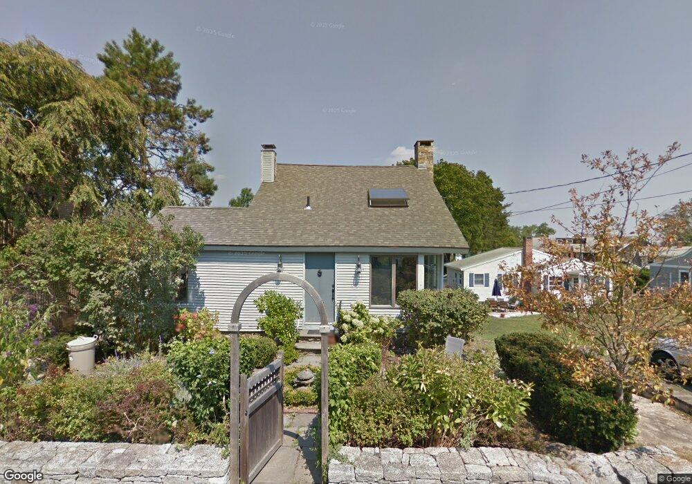
786 Mulberry Point Rd Guilford, CT 06437
Estimated Value: $514,000 - $718,826
1
Bed
2
Baths
1,113
Sq Ft
$568/Sq Ft
Est. Value
About This Home
This home is located at 786 Mulberry Point Rd, Guilford, CT 06437 and is currently estimated at $632,207, approximately $568 per square foot. 786 Mulberry Point Rd is a home located in New Haven County with nearby schools including E.C. Adams Middle School, A. Baldwin Middle School, and Guilford High School.
Ownership History
Date
Name
Owned For
Owner Type
Purchase Details
Closed on
Dec 31, 2008
Sold by
Boyce Elizabeth
Bought by
Marinan Christopher and Marinan Wendy
Current Estimated Value
Home Financials for this Owner
Home Financials are based on the most recent Mortgage that was taken out on this home.
Original Mortgage
$236,000
Interest Rate
6.08%
Create a Home Valuation Report for This Property
The Home Valuation Report is an in-depth analysis detailing your home's value as well as a comparison with similar homes in the area
Home Values in the Area
Average Home Value in this Area
Purchase History
| Date | Buyer | Sale Price | Title Company |
|---|---|---|---|
| Marinan Christopher | $266,000 | -- |
Source: Public Records
Mortgage History
| Date | Status | Borrower | Loan Amount |
|---|---|---|---|
| Closed | Marinan Christopher | $236,000 | |
| Previous Owner | Marinan Christopher | $45,000 |
Source: Public Records
Tax History
| Year | Tax Paid | Tax Assessment Tax Assessment Total Assessment is a certain percentage of the fair market value that is determined by local assessors to be the total taxable value of land and additions on the property. | Land | Improvement |
|---|---|---|---|---|
| 2025 | $11,524 | $416,780 | $349,860 | $66,920 |
| 2024 | $11,078 | $416,780 | $349,860 | $66,920 |
| 2023 | $10,786 | $416,780 | $349,860 | $66,920 |
| 2022 | $10,904 | $327,950 | $277,200 | $50,750 |
| 2021 | $10,698 | $327,950 | $277,200 | $50,750 |
| 2020 | $10,596 | $327,950 | $277,200 | $50,750 |
| 2019 | $10,504 | $327,950 | $277,200 | $50,750 |
| 2018 | $10,258 | $327,950 | $277,200 | $50,750 |
| 2017 | $9,972 | $339,650 | $280,670 | $58,980 |
| 2016 | $9,738 | $339,650 | $280,670 | $58,980 |
| 2015 | $9,592 | $339,650 | $280,670 | $58,980 |
| 2014 | $9,313 | $339,650 | $280,670 | $58,980 |
Source: Public Records
Map
Nearby Homes
- 76 Sachem Head Rd
- 39 Vineyard Place
- 405 Whitfield St Unit 2
- 379 Whitfield St Unit BN334
- 379 Whitfield St Unit CN946
- 379 Whitfield St Unit AN236
- 379 Whitfield St Unit BN2534
- 379 Whitfield St Unit CS936
- 505 Old Whitfield St
- 285 Old Whitfield St
- 25 Driveway
- 66 High St Unit 34
- 80 Seaview Terrace Unit 31
- 174 Whitfield St
- 223 Water St
- 26 Water St
- 215 Uncas Point Rd
- 24 Ridgewood Ave
- 147 Boston St
- 575 Leetes Island Rd
- 778 Mulberry Point Rd
- 790 Mulberry Point Rd
- 794 Mulberry Point Rd
- 52 Marshall Ave
- 56 Marshall Ave
- 798 Mulberry Point Rd
- 766 Mulberry Point Rd
- 777 Mulberry Point Rd
- 789 Mulberry Point Rd
- 789 Mulberry Point Rd Unit Weekly Rental
- 783 Mulberry Point Rd
- 773 Mulberry Point Rd
- 32 Marshall Ave
- 801 Mulberry Point Rd
- 38 Marshall Ave
- 763 Mulberry Point Rd
- 28 Marshall Ave
- 805 Mulberry Point Rd
- 805 Mulberry Point Rd
- 760 Mulberry Point Rd
Your Personal Tour Guide
Ask me questions while you tour the home.