Estimated Value: $368,624 - $570,000
--
Bed
--
Bath
1
Sq Ft
$510,906/Sq Ft
Est. Value
About This Home
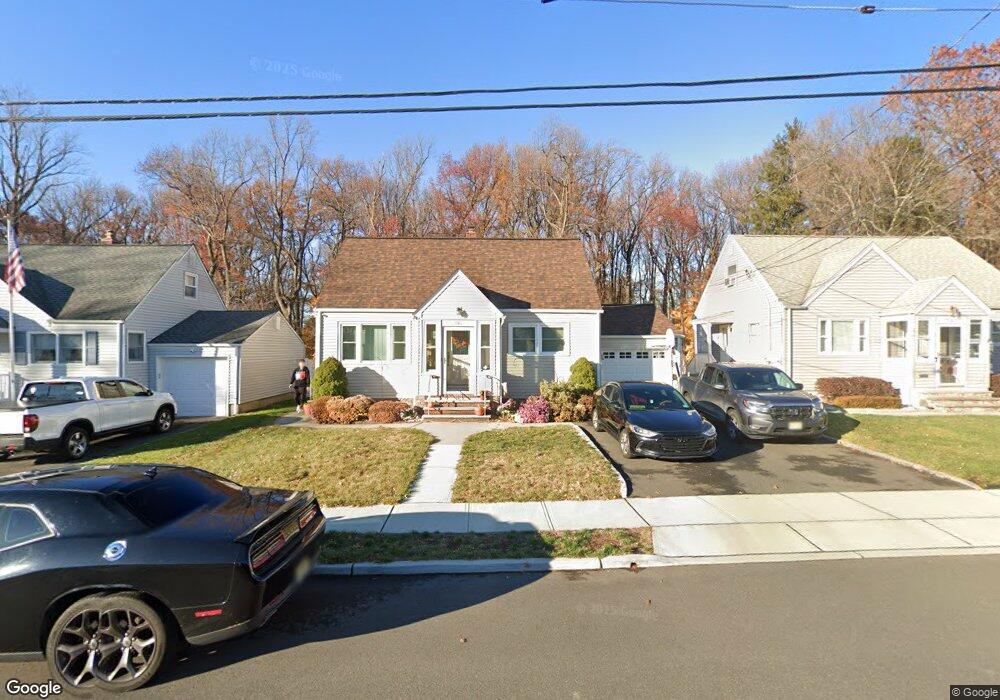
This home is located at 786 Pinewood Rd, Union, NJ 07083 and is currently estimated at $510,906, approximately $510,906 per square foot. 786 Pinewood Rd is a home located in Union County with nearby schools including Battle Hill Elementary School, Burnet Middle School, and Union High School.
Ownership History
Date
Name
Owned For
Owner Type
Purchase Details
Closed on
Sep 8, 1998
Sold by
Pita Antonio J and Pita Isabel M Branco
Bought by
Pita Antonio J and Pita Isabel Branco
Current Estimated Value
Purchase Details
Closed on
May 30, 1997
Sold by
Puleo Philip and Puleo Carrie
Bought by
Pita Antonio J and Branco Isabel M
Home Financials for this Owner
Home Financials are based on the most recent Mortgage that was taken out on this home.
Original Mortgage
$80,000
Interest Rate
7.54%
Create a Home Valuation Report for This Property
The Home Valuation Report is an in-depth analysis detailing your home's value as well as a comparison with similar homes in the area
Home Values in the Area
Average Home Value in this Area
Purchase History
| Date | Buyer | Sale Price | Title Company |
|---|---|---|---|
| Pita Antonio J | -- | -- | |
| Pita Antonio J | $152,500 | -- |
Source: Public Records
Mortgage History
| Date | Status | Borrower | Loan Amount |
|---|---|---|---|
| Closed | Pita Antonio J | $80,000 |
Source: Public Records
Tax History Compared to Growth
Tax History
| Year | Tax Paid | Tax Assessment Tax Assessment Total Assessment is a certain percentage of the fair market value that is determined by local assessors to be the total taxable value of land and additions on the property. | Land | Improvement |
|---|---|---|---|---|
| 2025 | $9,723 | $43,500 | $20,500 | $23,000 |
| 2024 | $9,426 | $43,500 | $20,500 | $23,000 |
| 2023 | $9,426 | $43,500 | $20,500 | $23,000 |
| 2022 | $9,098 | $43,500 | $20,500 | $23,000 |
| 2021 | $8,878 | $43,500 | $20,500 | $23,000 |
| 2020 | $8,701 | $43,500 | $20,500 | $23,000 |
| 2019 | $8,584 | $43,500 | $20,500 | $23,000 |
| 2018 | $8,438 | $43,500 | $20,500 | $23,000 |
| 2017 | $8,313 | $43,500 | $20,500 | $23,000 |
| 2016 | $8,110 | $43,500 | $20,500 | $23,000 |
| 2015 | $7,976 | $43,500 | $20,500 | $23,000 |
| 2014 | $7,797 | $43,500 | $20,500 | $23,000 |
Source: Public Records
Map
Nearby Homes
- 798 Pinewood Rd
- 767 Hemlock Rd
- 97 Battle Hill Ave
- 67 Battle Hill Ave
- 807 Andover Rd
- 6 Joanne Way
- 960 Moessner Ave
- 73 S Maple Ave
- 980 Moessner Ave
- 2857 Willard Place
- 2785 Larchmont Rd
- 2636 Frederick Terrace
- 1042 Battle Hill Terrace
- 1066 Mayfair Rd
- 1071 Battle Hill Terrace
- 17 Alvin Terrace
- 20 Maple Ave
- 587 Jesse Place
- 1035 Schneider Ave
- 2615 Burns Place
- 782 Pinewood Rd
- 790 Pinewood Rd
- 778 Pinewood Rd
- 794 Pinewood Rd
- 787 Pinewood Rd
- 791 Pinewood Rd
- 774 Pinewood Rd
- 783 Pinewood Rd
- 779 Pinewood Rd
- 802 Pinewood Rd
- 799 Pinewood Rd
- 768 Pinewood Rd
- 46 Filbert Ln
- 42 Filbert Ln
- 803 Pinewood Rd
- 806 Pinewood Rd
- 38 Filbert Ln
- 771 Pinewood Rd
- 764 Pinewood Rd
- 34 Filbert Ln