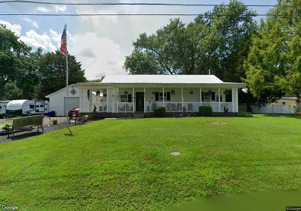
7869 Woodbine Rd Airville, PA 17302
Susquehanna Trails NeighborhoodEstimated Value: $207,000
4
Beds
2
Baths
1,632
Sq Ft
$127/Sq Ft
Est. Value
About This Home
This home is located at 7869 Woodbine Rd, Airville, PA 17302 and is currently priced at $207,000, approximately $126 per square foot. 7869 Woodbine Rd is a home located in York County with nearby schools including South Eastern Intermediate School, South Eastern Middle School, and Kennard-Dale High School.
Ownership History
Date
Name
Owned For
Owner Type
Purchase Details
Closed on
Jun 15, 2017
Sold by
Cosgrove Laura J and Dorrier Laura J
Bought by
Dorrier William Franklin and Dorrier Laura J
Current Estimated Value
Home Financials for this Owner
Home Financials are based on the most recent Mortgage that was taken out on this home.
Original Mortgage
$200,000
Outstanding Balance
$166,495
Interest Rate
4.05%
Mortgage Type
VA
Purchase Details
Closed on
Jul 8, 1994
Sold by
Martin Niles W Est
Bought by
Cosgrove Laura J
Create a Home Valuation Report for This Property
The Home Valuation Report is an in-depth analysis detailing your home's value as well as a comparison with similar homes in the area
Home Values in the Area
Average Home Value in this Area
Purchase History
| Date | Buyer | Sale Price | Title Company |
|---|---|---|---|
| Dorrier William Franklin | -- | None Available | |
| Cosgrove Laura J | $58,000 | -- |
Source: Public Records
Mortgage History
| Date | Status | Borrower | Loan Amount |
|---|---|---|---|
| Open | Dorrier William Franklin | $200,000 |
Source: Public Records
Tax History Compared to Growth
Tax History
| Year | Tax Paid | Tax Assessment Tax Assessment Total Assessment is a certain percentage of the fair market value that is determined by local assessors to be the total taxable value of land and additions on the property. | Land | Improvement |
|---|---|---|---|---|
| 2025 | -- | $0 | $0 | $0 |
| 2024 | -- | $0 | $0 | $0 |
| 2023 | $4,462 | $0 | $0 | $0 |
| 2022 | $4,225 | $0 | $0 | $0 |
| 2021 | $4,314 | $0 | $0 | $0 |
| 2020 | $4,240 | $0 | $0 | $0 |
| 2019 | $4,225 | $0 | $0 | $0 |
| 2018 | $4,225 | $0 | $0 | $0 |
| 2017 | $4,225 | $148,140 | $33,160 | $114,980 |
| 2016 | $0 | $148,140 | $33,160 | $114,980 |
| 2015 | -- | $148,140 | $33,160 | $114,980 |
| 2014 | -- | $148,140 | $33,160 | $114,980 |
Source: Public Records
Map
Nearby Homes
- 63 Cherry Rd
- 76 Laurel Dr
- 0 Highview Dr
- 45 Wenzel Rd
- 0 Dogwood Rd
- 53 Dogwood Rd
- Parcel 859 Neill Run Rd
- 46 Corn Tassel Rd
- 8290 Woodbine Rd
- 55 Highfield Rd
- 216 Meadow Trail
- 556 Bair Rd
- 115 Highfield Rd
- 0 Valley Ln
- Lot C Bryansville Rd
- 65 W Mckinley Rd
- Lot 4 Ridge Rd
- 267 Cook Rd
- 194 Cook Rd
- 1081 Bridgeton Rd