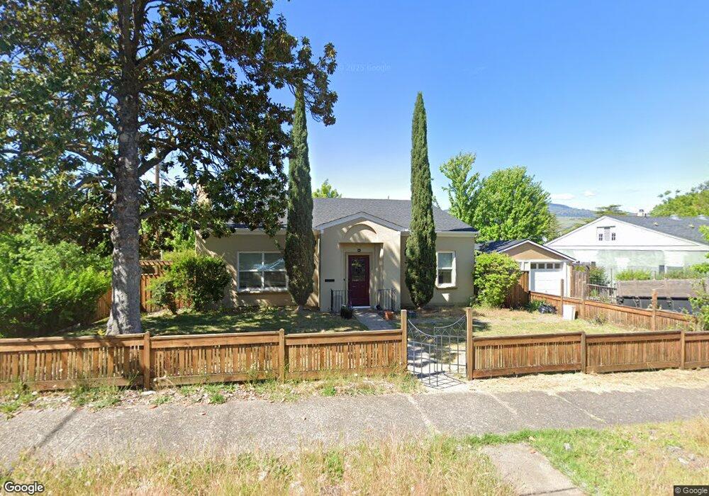
787 Iowa St Ashland, OR 97520
3 Tiers of Ashland NeighborhoodEstimated Value: $467,459 - $588,000
3
Beds
1
Bath
1,464
Sq Ft
$365/Sq Ft
Est. Value
About This Home
This home is located at 787 Iowa St, Ashland, OR 97520 and is currently estimated at $534,365, approximately $365 per square foot. 787 Iowa St is a home located in Jackson County with nearby schools including Walker Elementary School, Ashland Middle School, and Ashland High School.
Ownership History
Date
Name
Owned For
Owner Type
Purchase Details
Closed on
Jan 3, 2025
Sold by
Locklin Kimberlynn M
Bought by
Kimberlynn Martin Locklin Revocable Trust
Current Estimated Value
Purchase Details
Closed on
Sep 12, 2000
Sold by
Munsell Glenn H and Estate Of H Margaret Biegel
Bought by
Locklin Kimberlynn M
Home Financials for this Owner
Home Financials are based on the most recent Mortgage that was taken out on this home.
Original Mortgage
$164,000
Interest Rate
8.11%
Create a Home Valuation Report for This Property
The Home Valuation Report is an in-depth analysis detailing your home's value as well as a comparison with similar homes in the area
Home Values in the Area
Average Home Value in this Area
Purchase History
| Date | Buyer | Sale Price | Title Company |
|---|---|---|---|
| Kimberlynn Martin Locklin Revocable Trust | -- | None Listed On Document | |
| Kimberlynn Martin Locklin Revocable Trust | -- | None Listed On Document | |
| Locklin Kimberlynn M | $209,000 | Jackson County Title |
Source: Public Records
Mortgage History
| Date | Status | Borrower | Loan Amount |
|---|---|---|---|
| Previous Owner | Locklin Kimberlynn M | $164,000 |
Source: Public Records
Tax History Compared to Growth
Tax History
| Year | Tax Paid | Tax Assessment Tax Assessment Total Assessment is a certain percentage of the fair market value that is determined by local assessors to be the total taxable value of land and additions on the property. | Land | Improvement |
|---|---|---|---|---|
| 2025 | $4,091 | $263,840 | $160,630 | $103,210 |
| 2024 | $4,091 | $256,160 | $155,960 | $100,200 |
| 2023 | $3,957 | $248,700 | $151,420 | $97,280 |
| 2022 | $3,831 | $248,700 | $151,420 | $97,280 |
| 2021 | $3,700 | $241,460 | $147,010 | $94,450 |
| 2020 | $3,596 | $234,430 | $142,730 | $91,700 |
| 2019 | $3,540 | $220,990 | $134,550 | $86,440 |
| 2018 | $3,344 | $214,560 | $130,640 | $83,920 |
| 2017 | $3,320 | $214,560 | $130,640 | $83,920 |
| 2016 | $3,233 | $202,260 | $123,150 | $79,110 |
| 2015 | $3,108 | $202,260 | $123,150 | $79,110 |
| 2014 | $3,007 | $190,660 | $116,090 | $74,570 |
Source: Public Records
Map
Nearby Homes
- 200 Morton St
- 748 1/2 Siskiyou Blvd
- 765 Iowa St
- 197 Morton St
- 221 Liberty St
- 219 Liberty St
- 790 Iowa St
- 748 Siskiyou Blvd
- 788 Iowa St
- 820 Iowa St
- 193 Morton St
- 724 Siskiyou Blvd
- 195 Morton St
- 712 Siskiyou Blvd
- 745 Iowa St
- 830 Iowa St
- 756 Iowa St
- 744 Iowa St
- 270 Morton St
- 270 Morton St Unit Garden Suite