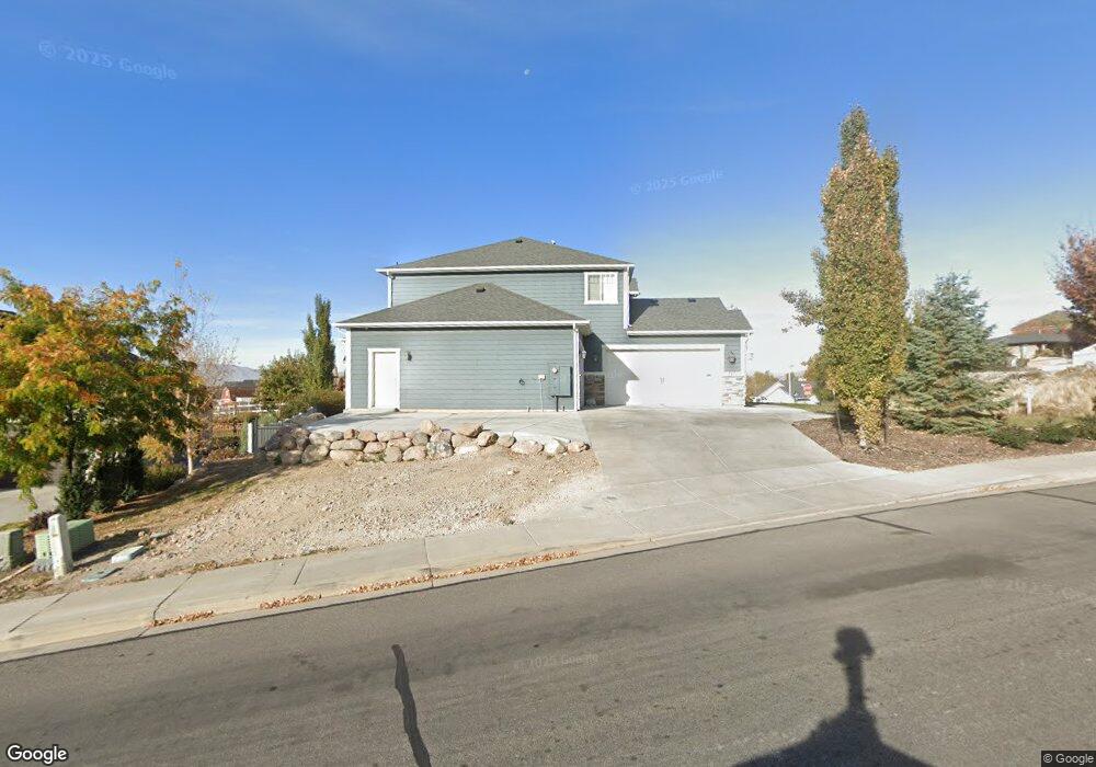
787 N 650 E Unit 1 Lindon, UT 84042
Estimated Value: $904,000 - $1,173,000
4
Beds
4
Baths
2,709
Sq Ft
$379/Sq Ft
Est. Value
About This Home
This home is located at 787 N 650 E Unit 1, Lindon, UT 84042 and is currently estimated at $1,026,938, approximately $379 per square foot. 787 N 650 E Unit 1 is a home located in Utah County with nearby schools including Lindon Elementary School, Oak Canyon Junior High School, and Pleasant Grove High School.
Ownership History
Date
Name
Owned For
Owner Type
Purchase Details
Closed on
Jul 23, 2014
Sold by
Guernsey Quentin S and Guernsey Jessica A
Bought by
Guernsey Quentin S and Guernsey Jessica
Current Estimated Value
Home Financials for this Owner
Home Financials are based on the most recent Mortgage that was taken out on this home.
Original Mortgage
$417,000
Outstanding Balance
$317,630
Interest Rate
4.16%
Mortgage Type
New Conventional
Estimated Equity
$709,308
Purchase Details
Closed on
Dec 4, 2013
Sold by
Commonwealth Land Title Insurance Co
Bought by
Guernsey Quentin S and Guernsey Jessica A
Purchase Details
Closed on
Apr 6, 2007
Sold by
Metcalf Gary M
Bought by
Commonwealth Land Title Insurance Co
Purchase Details
Closed on
Dec 8, 2005
Sold by
Louder Chad
Bought by
Metcalf Gary M
Home Financials for this Owner
Home Financials are based on the most recent Mortgage that was taken out on this home.
Original Mortgage
$442,500
Interest Rate
6.31%
Mortgage Type
Construction
Purchase Details
Closed on
Sep 21, 2005
Sold by
Draper Michel Timothy and Draper Diana L
Bought by
Louder Chad
Home Financials for this Owner
Home Financials are based on the most recent Mortgage that was taken out on this home.
Original Mortgage
$175,000
Interest Rate
5.81%
Mortgage Type
Purchase Money Mortgage
Purchase Details
Closed on
Apr 27, 2005
Sold by
Draper Diana
Bought by
Draper Michel Timothy and Draper Diana L
Home Financials for this Owner
Home Financials are based on the most recent Mortgage that was taken out on this home.
Original Mortgage
$445,550
Interest Rate
5.92%
Mortgage Type
Construction
Purchase Details
Closed on
Mar 18, 2005
Sold by
H5 Development Lc
Bought by
Draper Diana
Home Financials for this Owner
Home Financials are based on the most recent Mortgage that was taken out on this home.
Original Mortgage
$445,550
Interest Rate
5.92%
Mortgage Type
Construction
Create a Home Valuation Report for This Property
The Home Valuation Report is an in-depth analysis detailing your home's value as well as a comparison with similar homes in the area
Home Values in the Area
Average Home Value in this Area
Purchase History
| Date | Buyer | Sale Price | Title Company |
|---|---|---|---|
| Guernsey Quentin S | -- | Morgan Title & Escrow Inc | |
| Guernsey Quentin S | -- | Founders Title Co | |
| Commonwealth Land Title Insurance Co | -- | Meridian Title Company | |
| Metcalf Gary M | -- | Meridian Title Company | |
| Louder Chad | -- | Atlas Title | |
| Draper Michel Timothy | -- | Atlas Title | |
| Draper Diana | -- | Title West Title Company |
Source: Public Records
Mortgage History
| Date | Status | Borrower | Loan Amount |
|---|---|---|---|
| Open | Guernsey Quentin S | $417,000 | |
| Previous Owner | Metcalf Gary M | $442,500 | |
| Previous Owner | Louder Chad | $175,000 | |
| Previous Owner | Draper Michel Timothy | $445,550 | |
| Previous Owner | Draper Diana | $126,000 |
Source: Public Records
Tax History
| Year | Tax Paid | Tax Assessment Tax Assessment Total Assessment is a certain percentage of the fair market value that is determined by local assessors to be the total taxable value of land and additions on the property. | Land | Improvement |
|---|---|---|---|---|
| 2025 | $4,076 | $545,600 | -- | -- |
| 2024 | $4,076 | $502,425 | $0 | $0 |
| 2023 | $3,847 | $509,465 | $0 | $0 |
| 2022 | $4,522 | $578,380 | $0 | $0 |
| 2021 | $4,394 | $847,400 | $222,000 | $625,400 |
| 2020 | $4,230 | $803,100 | $201,800 | $601,300 |
| 2019 | $3,974 | $787,200 | $185,900 | $601,300 |
| 2018 | $3,711 | $693,000 | $170,100 | $522,900 |
| 2017 | $3,666 | $367,070 | $0 | $0 |
| 2016 | $3,514 | $325,435 | $0 | $0 |
| 2015 | $3,232 | $282,975 | $0 | $0 |
| 2014 | $1,642 | $142,400 | $0 | $0 |
Source: Public Records
Map
Nearby Homes
- 787 N 650 E
- 1886 Murdock
- 1844 Murdock
- 773 N 650 E Unit 2
- 663 E 770 N Unit 40
- 663 E 770 N
- 1705 E Murdock Dr
- 668 E 770 N Unit 39
- 668 E 770 N
- 677 E 770 N Unit 38
- 1695 E 1000 S
- 1695 E Murdock Dr
- 975 Cherokee Dr
- 639 E 720 N
- 682 E 770 N Unit 39
- 682 E 770 N
- 689 E 770 N
- 689 E 770 N Unit 36
- 689 E 770 N
- 1685 E Murdock Dr
Your Personal Tour Guide
Ask me questions while you tour the home.