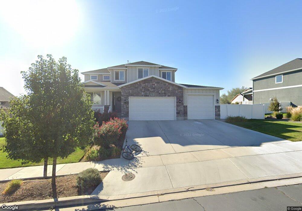
787 N 700 W American Fork, UT 84003
Estimated Value: $763,000 - $1,326,000
4
Beds
3
Baths
2,782
Sq Ft
$376/Sq Ft
Est. Value
About This Home
This home is located at 787 N 700 W, American Fork, UT 84003 and is currently estimated at $1,046,899, approximately $376 per square foot. 787 N 700 W is a home located in Utah County with nearby schools including Shelley Elementary School, American Fork Junior High School, and American Fork High School.
Ownership History
Date
Name
Owned For
Owner Type
Purchase Details
Closed on
Feb 9, 2016
Sold by
Camberlango Devewlopment Group Llc
Bought by
Reid Jason Matthew and Reid Alisa D
Current Estimated Value
Home Financials for this Owner
Home Financials are based on the most recent Mortgage that was taken out on this home.
Original Mortgage
$417,000
Outstanding Balance
$332,748
Interest Rate
3.98%
Mortgage Type
New Conventional
Estimated Equity
$714,151
Create a Home Valuation Report for This Property
The Home Valuation Report is an in-depth analysis detailing your home's value as well as a comparison with similar homes in the area
Home Values in the Area
Average Home Value in this Area
Purchase History
| Date | Buyer | Sale Price | Title Company |
|---|---|---|---|
| Reid Jason Matthew | -- | Provo Land Title Co |
Source: Public Records
Mortgage History
| Date | Status | Borrower | Loan Amount |
|---|---|---|---|
| Open | Reid Jason Matthew | $417,000 |
Source: Public Records
Tax History Compared to Growth
Tax History
| Year | Tax Paid | Tax Assessment Tax Assessment Total Assessment is a certain percentage of the fair market value that is determined by local assessors to be the total taxable value of land and additions on the property. | Land | Improvement |
|---|---|---|---|---|
| 2025 | $3,750 | $456,500 | $302,200 | $527,800 |
| 2024 | $3,750 | $416,625 | $0 | $0 |
| 2023 | $3,587 | $422,510 | $0 | $0 |
| 2022 | $3,600 | $418,550 | $0 | $0 |
| 2021 | $3,162 | $574,200 | $211,600 | $362,600 |
| 2020 | $3,073 | $541,200 | $195,900 | $345,300 |
| 2019 | $2,724 | $496,200 | $195,900 | $300,300 |
| 2018 | $2,580 | $449,400 | $188,300 | $261,100 |
| 2017 | $2,413 | $226,765 | $0 | $0 |
| 2016 | $2,427 | $211,915 | $0 | $0 |
| 2015 | $1,745 | $144,600 | $0 | $0 |
| 2014 | $1,769 | $144,600 | $0 | $0 |
Source: Public Records
Map
Nearby Homes
- 822 W 800 St N Unit LOT319
- 822 N 860 W Unit 317
- 962 N 780 St W Unit 508
- 974 N 780 St W Unit 509
- 916 N 780 St W Unit 501
- 602 W 860 N
- 3935 W 1000 N Unit 438
- 3983 W 1000 N Unit 442
- 4007 W 1000 N
- 3947 W 1000 N Unit 439
- 3959 W 1000 N
- 901 N Lakota Rd
- 987 N 410 W
- 641 N 420 W
- 471 W 1040 N
- 777 W State Rd
- 914 N 400 W Unit A
- 893 N 1580 E
- 418 N 1322 E
- 3889 W 950 Cir N Unit 366
- 787 N 700 W Unit 24
- 775 N 700 W Unit 23
- 775 N 700 W
- 809 N 700 W Unit 25
- 809 N 700 W
- 797 W 800 N
- 802 N 780 W
- 778 N 780 St W
- 812 N 780 St W
- 812 N 780 St W Unit LOT303
- 788 N 700 W Unit 8
- 802 N 700 W
- 821 N 700 W Unit 26
- 821 N 700 W
- 776 N 700 W Unit 9
- 763 N 700 W Unit 22
- 763 N 700 W
- 764 N 780 W Unit 107
- 818 N 780 W
- 754 N 700 W Unit 10