Estimated Value: $494,000 - $631,000
3
Beds
2
Baths
1,580
Sq Ft
$341/Sq Ft
Est. Value
About This Home
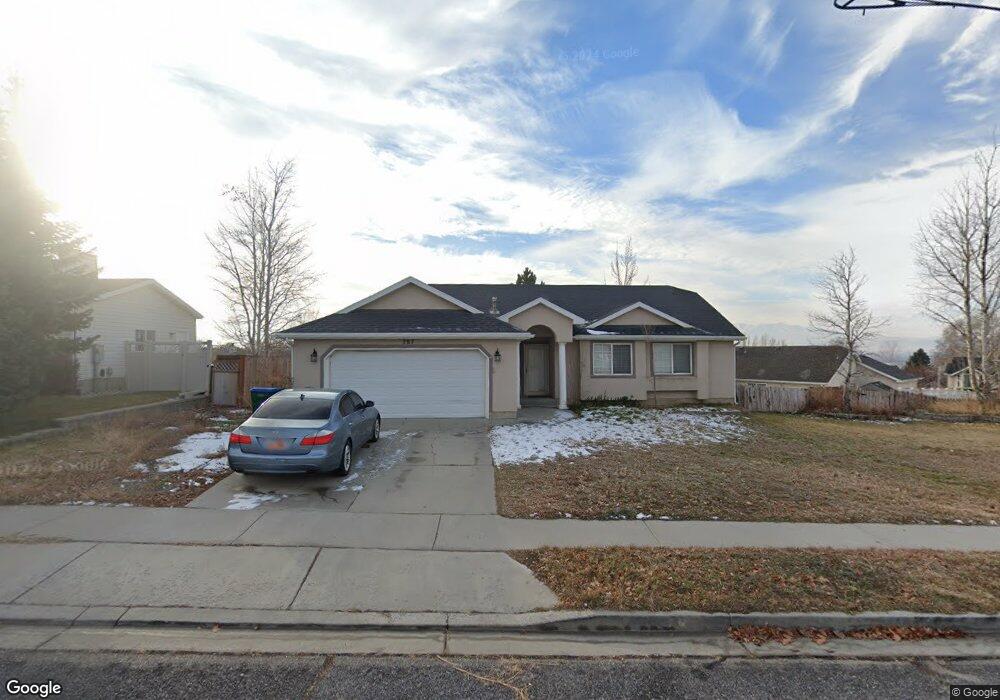
This home is located at 787 W 2600 N, Lehi, UT 84043 and is currently estimated at $539,051, approximately $341 per square foot. 787 W 2600 N is a home located in Utah County with nearby schools including Fox Hollow Elementary School, Skyridge High School, and Ignite Entrepreneurship Academy.
Ownership History
Date
Name
Owned For
Owner Type
Purchase Details
Closed on
Nov 25, 2014
Sold by
American Homes 4 Rent Properties Five Ll
Bought by
Amh 2014 3 Borrower Llc
Current Estimated Value
Purchase Details
Closed on
May 6, 2013
Sold by
Holbrook Scott A
Bought by
American Homes 4 Rent Properties Five Ll
Purchase Details
Closed on
Apr 6, 2011
Sold by
Holbrook Scott A
Bought by
Smbs Real Estate
Purchase Details
Closed on
Jun 22, 2009
Sold by
Wood Nigel J and Wood Tricia F
Bought by
Holbrook Scott A
Purchase Details
Closed on
Feb 17, 2004
Sold by
Shumway Robert and Shumway Julia L
Bought by
Wood Nigel J and Wood Tricia F
Home Financials for this Owner
Home Financials are based on the most recent Mortgage that was taken out on this home.
Original Mortgage
$114,400
Interest Rate
5.85%
Mortgage Type
Purchase Money Mortgage
Purchase Details
Closed on
Mar 14, 2001
Sold by
Dalsing Jason M
Bought by
Shumway Robert and Shumway Julia L
Home Financials for this Owner
Home Financials are based on the most recent Mortgage that was taken out on this home.
Original Mortgage
$138,953
Interest Rate
7.11%
Mortgage Type
FHA
Purchase Details
Closed on
Apr 17, 1999
Sold by
Johnson Matthew Ty and Johnson Pamela S
Bought by
Dalsing Jason M and Dalsing Sarah D
Home Financials for this Owner
Home Financials are based on the most recent Mortgage that was taken out on this home.
Original Mortgage
$127,149
Interest Rate
6.98%
Mortgage Type
FHA
Purchase Details
Closed on
Jun 3, 1996
Sold by
Ridgepoint Homes
Bought by
Johnson Matthew Ty and Johnson Pamela S
Home Financials for this Owner
Home Financials are based on the most recent Mortgage that was taken out on this home.
Original Mortgage
$111,196
Interest Rate
7.96%
Mortgage Type
FHA
Create a Home Valuation Report for This Property
The Home Valuation Report is an in-depth analysis detailing your home's value as well as a comparison with similar homes in the area
Home Values in the Area
Average Home Value in this Area
Purchase History
| Date | Buyer | Sale Price | Title Company |
|---|---|---|---|
| Amh 2014 3 Borrower Llc | -- | None Available | |
| American Homes 4 Rent Properties Five Ll | -- | None Available | |
| Smbs Real Estate | -- | Accommodation | |
| Holbrook Scott A | -- | Eagle Pointe Title Insuranc | |
| Wood Nigel J | -- | Eagle Pointe Title | |
| Shumway Robert | -- | Title West Title Co | |
| Dalsing Jason M | -- | First American Title Co | |
| Johnson Matthew Ty | -- | -- |
Source: Public Records
Mortgage History
| Date | Status | Borrower | Loan Amount |
|---|---|---|---|
| Previous Owner | Wood Nigel J | $114,400 | |
| Previous Owner | Shumway Robert | $138,953 | |
| Previous Owner | Dalsing Jason M | $127,149 | |
| Previous Owner | Johnson Matthew Ty | $111,196 | |
| Closed | Wood Nigel J | $21,450 |
Source: Public Records
Tax History Compared to Growth
Tax History
| Year | Tax Paid | Tax Assessment Tax Assessment Total Assessment is a certain percentage of the fair market value that is determined by local assessors to be the total taxable value of land and additions on the property. | Land | Improvement |
|---|---|---|---|---|
| 2025 | $1,889 | $241,505 | $199,900 | $239,200 |
| 2024 | $1,889 | $221,100 | $0 | $0 |
| 2023 | $1,742 | $221,320 | $0 | $0 |
| 2022 | $1,879 | $231,495 | $0 | $0 |
| 2021 | $1,653 | $307,900 | $115,700 | $192,200 |
| 2020 | $1,557 | $286,700 | $107,100 | $179,600 |
| 2019 | $1,447 | $277,000 | $107,100 | $169,900 |
| 2018 | $1,372 | $248,200 | $97,700 | $150,500 |
| 2017 | $1,316 | $126,555 | $0 | $0 |
| 2016 | $1,298 | $115,830 | $0 | $0 |
| 2015 | $1,221 | $103,400 | $0 | $0 |
| 2014 | $1,205 | $101,475 | $0 | $0 |
Source: Public Records
Map
Nearby Homes
- 804 W 2700 N
- 2687 N 900 W
- 2287 N 750 W
- 2778 N 930 W
- 537 W Sandhill Dr
- 497 W 2280 N
- 595 W 2200 N
- 497 W 2200 N
- 2946 N 1080 W
- 1155 W 2980 N
- 1167 W 2980 N
- 1179 W 2980 N
- Rhapsody Plan at Lehi Terrace
- Gallivan Plan at Lehi Terrace
- Concerto Plan at Lehi Terrace
- Grand Plan at Lehi Terrace
- Arietta Plan at Lehi Terrace
- Libby Plan at Lehi Terrace
- Rose Plan at Lehi Terrace
- Capitol Plan at Lehi Terrace