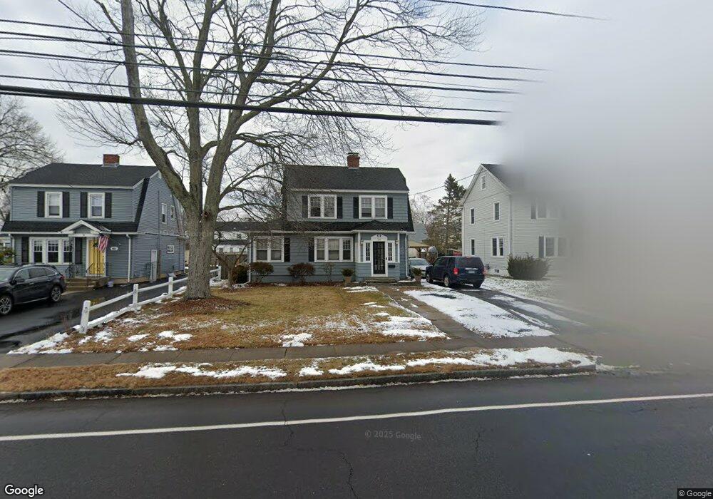
79 Newington Rd West Hartford, CT 06110
Estimated Value: $346,000 - $385,377
3
Beds
2
Baths
1,404
Sq Ft
$258/Sq Ft
Est. Value
About This Home
This home is located at 79 Newington Rd, West Hartford, CT 06110 and is currently estimated at $361,844, approximately $257 per square foot. 79 Newington Rd is a home located in Hartford County with nearby schools including Wolcott School, Sedgwick Middle School, and Conard High School.
Ownership History
Date
Name
Owned For
Owner Type
Purchase Details
Closed on
Feb 8, 2002
Sold by
Reale Andrew D and Reale John K
Bought by
Altamirano Walter
Current Estimated Value
Purchase Details
Closed on
Nov 9, 1988
Sold by
Francini T J
Bought by
Reale J K
Create a Home Valuation Report for This Property
The Home Valuation Report is an in-depth analysis detailing your home's value as well as a comparison with similar homes in the area
Home Values in the Area
Average Home Value in this Area
Purchase History
| Date | Buyer | Sale Price | Title Company |
|---|---|---|---|
| Altamirano Walter | $142,500 | -- | |
| Reale J K | $138,000 | -- |
Source: Public Records
Mortgage History
| Date | Status | Borrower | Loan Amount |
|---|---|---|---|
| Open | Reale J K | $26,400 | |
| Open | Reale J K | $162,025 | |
| Closed | Reale J K | $194,000 |
Source: Public Records
Tax History Compared to Growth
Tax History
| Year | Tax Paid | Tax Assessment Tax Assessment Total Assessment is a certain percentage of the fair market value that is determined by local assessors to be the total taxable value of land and additions on the property. | Land | Improvement |
|---|---|---|---|---|
| 2025 | $7,022 | $156,810 | $52,300 | $104,510 |
| 2024 | $6,641 | $156,810 | $52,300 | $104,510 |
| 2023 | $6,417 | $156,810 | $52,300 | $104,510 |
| 2022 | $6,379 | $156,810 | $52,300 | $104,510 |
| 2021 | $5,464 | $128,800 | $50,300 | $78,500 |
| 2020 | $5,384 | $128,800 | $42,300 | $86,500 |
| 2019 | $5,384 | $128,800 | $42,280 | $86,520 |
| 2018 | $5,281 | $128,800 | $42,280 | $86,520 |
| 2017 | $5,286 | $128,800 | $42,280 | $86,520 |
| 2016 | $5,332 | $134,960 | $49,210 | $85,750 |
| 2015 | $5,170 | $134,960 | $49,210 | $85,750 |
| 2014 | $5,043 | $134,960 | $49,210 | $85,750 |
Source: Public Records
Map
Nearby Homes
- 41 Page Ave
- 1145 New Britain Ave
- 121 Cambridge St
- 49 Somerset St
- 90 Park Place Cir Unit 90
- 49 Park Place Cir Unit 49
- 61 Colonial St
- 148 Colonial St
- 39 Cortland St
- 107 Westgate St
- 18 Federal St
- 204 Trout Brook Dr
- 17 Parkview Rd
- 422 S Main St
- 479 S Main St
- 741 Quaker Ln S
- 24 Thorne Rd Unit 24
- 29 Sunnyside Rd
- 90 Meriline Ave
- 937 New Britain Ave