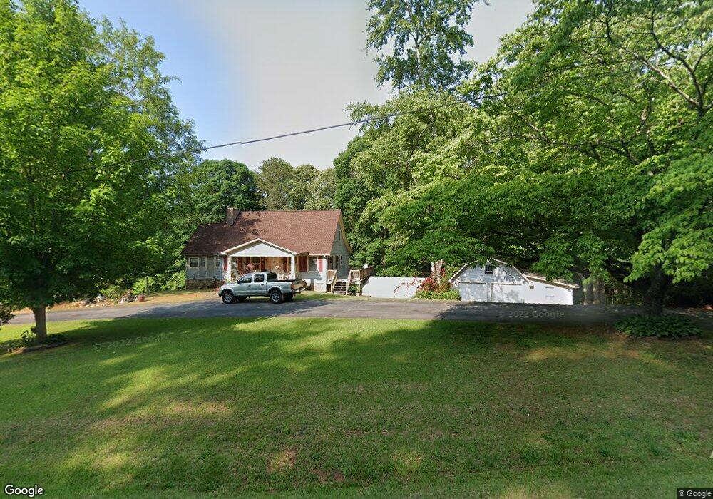
7901 W Currahee St Toccoa, GA 30577
Estimated Value: $232,000 - $336,000
2
Beds
2
Baths
1,683
Sq Ft
$160/Sq Ft
Est. Value
About This Home
This home is located at 7901 W Currahee St, Toccoa, GA 30577 and is currently estimated at $268,804, approximately $159 per square foot. 7901 W Currahee St is a home with nearby schools including Stephens County High School.
Ownership History
Date
Name
Owned For
Owner Type
Purchase Details
Closed on
Apr 16, 2020
Sold by
Cart Robert
Bought by
Carter George Michael
Current Estimated Value
Home Financials for this Owner
Home Financials are based on the most recent Mortgage that was taken out on this home.
Original Mortgage
$67,500
Outstanding Balance
$46,759
Interest Rate
3.2%
Mortgage Type
New Conventional
Estimated Equity
$222,045
Purchase Details
Closed on
Mar 29, 1975
Sold by
Turner James Gerald
Bought by
Carter Robert and Carter Betty
Purchase Details
Closed on
Feb 7, 1973
Sold by
Garland Thad A and Faite Richard
Bought by
Turner James Gerald
Purchase Details
Closed on
Apr 18, 1953
Sold by
Stewart James H
Bought by
Kell Thurman Ray
Create a Home Valuation Report for This Property
The Home Valuation Report is an in-depth analysis detailing your home's value as well as a comparison with similar homes in the area
Home Values in the Area
Average Home Value in this Area
Purchase History
| Date | Buyer | Sale Price | Title Company |
|---|---|---|---|
| Carter George Michael | -- | -- | |
| Carter Robert | -- | -- | |
| Turner James Gerald | -- | -- | |
| Kell Thurman Ray | -- | -- |
Source: Public Records
Mortgage History
| Date | Status | Borrower | Loan Amount |
|---|---|---|---|
| Open | Carter George Michael | $67,500 |
Source: Public Records
Tax History Compared to Growth
Tax History
| Year | Tax Paid | Tax Assessment Tax Assessment Total Assessment is a certain percentage of the fair market value that is determined by local assessors to be the total taxable value of land and additions on the property. | Land | Improvement |
|---|---|---|---|---|
| 2024 | $328 | $46,814 | $4,278 | $42,536 |
| 2023 | $243 | $44,108 | $4,278 | $39,830 |
| 2022 | $189 | $42,286 | $4,278 | $38,008 |
| 2021 | $114 | $39,575 | $4,278 | $35,297 |
| 2020 | $141 | $40,403 | $5,104 | $35,299 |
| 2019 | -- | $39,939 | $4,640 | $35,299 |
| 2018 | -- | $39,939 | $4,640 | $35,299 |
| 2017 | $129 | $39,939 | $4,640 | $35,299 |
| 2016 | $130 | $39,939 | $4,640 | $35,299 |
Source: Public Records
Map
Nearby Homes
- 0 Hammond Dr Unit 10578616
- 0 Louden Ridge Rd Unit 10578243
- 0 Louden Ridge Rd Unit 7627451
- 191 Shadow Walk Dr
- 339 Ben Loudermilk Rd
- 0 S Highway 365 Unit 10006827
- 1886 Bend N Hickory Rd
- 441 Expressway
- 3806 Antioch Church Rd
- 209 Hazel Creek Rd
- 192 Stonington Dr
- 278 Oakwood Place
- 458 Stonington Dr
- 110 Waterloo Dr
- 123 Talmadge Dr
- 144 Rolling Ridge Rd
- 268 Northwoods Dr
- 1605 Cody Rd
- 0 N Highway 365 Unit 10006830
- 4 Piedmont
- 7731 W Currahee St
- 7661 W Currahee St
- 8900 Dicks Hill Pkwy
- 8900 Dicks Hill Pkwy Unit B
- 8900 Dicks Hill Pkwy Unit A
- 8910 Dicks Hill Pkwy
- 7641 W Currahee St
- 7862 W Currahee St
- 8910 Dicks Hill Pkwy
- 7632 W Currahee St
- 312 Birch Ln
- 8469 Dicks Hill Pkwy
- 0 Birch Ln Unit 7577664
- 0 Birch Ln Unit 7509908
- 0 Birch Ln
- 7464 W Currahee St
- 195 Four Winds Dr
- 216 Four Winds Dr
- 8600 Dicks Hill Pkwy
- 7439 W Currahee St