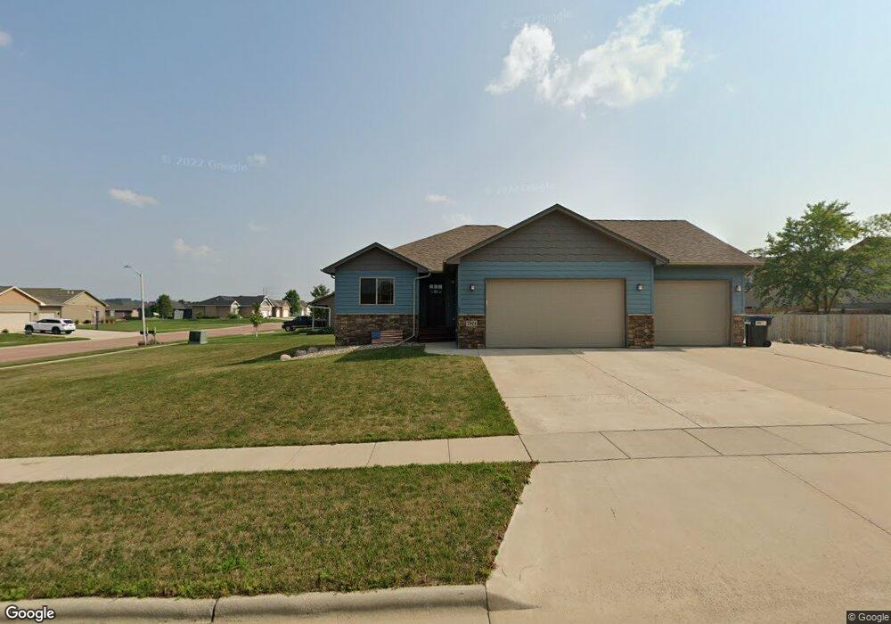
7901 W Kelsey St Sioux Falls, SD 57106
Northwest Sioux Falls NeighborhoodEstimated Value: $418,493 - $464,000
4
Beds
3
Baths
2,089
Sq Ft
$208/Sq Ft
Est. Value
About This Home
This home is located at 7901 W Kelsey St, Sioux Falls, SD 57106 and is currently estimated at $433,623, approximately $207 per square foot. 7901 W Kelsey St is a home located in Minnehaha County with nearby schools including Discovery Elementary School, Memorial Middle School, and Jefferson High School - 67.
Ownership History
Date
Name
Owned For
Owner Type
Purchase Details
Closed on
May 27, 2014
Bought by
Fjeldheim Craig L
Current Estimated Value
Home Financials for this Owner
Home Financials are based on the most recent Mortgage that was taken out on this home.
Original Mortgage
$185,900
Outstanding Balance
$141,824
Interest Rate
4.28%
Mortgage Type
New Conventional
Estimated Equity
$291,799
Create a Home Valuation Report for This Property
The Home Valuation Report is an in-depth analysis detailing your home's value as well as a comparison with similar homes in the area
Home Values in the Area
Average Home Value in this Area
Purchase History
| Date | Buyer | Sale Price | Title Company |
|---|---|---|---|
| Fjeldheim Craig L | $232,400 | Getty Abstract & Title Comp |
Source: Public Records
Mortgage History
| Date | Status | Borrower | Loan Amount |
|---|---|---|---|
| Open | Fjeldheim Craig L | $185,900 |
Source: Public Records
Tax History Compared to Growth
Tax History
| Year | Tax Paid | Tax Assessment Tax Assessment Total Assessment is a certain percentage of the fair market value that is determined by local assessors to be the total taxable value of land and additions on the property. | Land | Improvement |
|---|---|---|---|---|
| 2024 | $5,190 | $381,100 | $34,400 | $346,700 |
| 2023 | $5,335 | $377,900 | $34,400 | $343,500 |
| 2022 | $5,258 | $351,400 | $34,400 | $317,000 |
| 2021 | $3,975 | $290,500 | $0 | $0 |
| 2020 | $3,975 | $252,700 | $0 | $0 |
| 2019 | $3,900 | $243,552 | $0 | $0 |
| 2018 | $3,598 | $238,387 | $0 | $0 |
| 2016 | $3,443 | $215,674 | $36,936 | $178,738 |
| 2015 | $3,411 | $205,493 | $34,884 | $170,609 |
| 2014 | -- | $200,524 | $34,884 | $165,640 |
Source: Public Records
Map
Nearby Homes
- 7805 W Noah Cir
- 7809 W Stoney Creek St
- 8008 W Browning St
- 604 S Mary Gene Ave
- 501 S Mary Gene Ave
- 1200 S Monticello Ave
- 7524 W Boysenberry St
- 8709 W Rathburn St
- 521 S Big Stone Ave
- 7517 W 15th St
- 1301 Hyannis Port Ln
- 7512 W Stoney Creek St
- 1209 S Discovery Ave
- 8605 W Bryggen Ct
- 1315 S President Ct
- 1501 S Wheatland Ave
- 8905 W 18th St
- 100 N Bryggen Place
- 102 N Bryggen Place
- 104 N Bryggen Place
- 705 S Clearbrook Ave
- 700 S Whitewood Ave
- 709 S Clearbrook Ave
- 609 S Clearbrook Ave
- 704 S Whitewood Ave
- 612 S Whitewood Ave
- 708 S Whitewood Ave
- 700 S Clearbrook Ave
- 704 S Clearbrook Ave
- 605 S Clearbrook Ave
- 608 S Clearbrook Ave
- 712 S Whitewood Ave
- 713 S Clearbrook Ave
- 608 S Whitewood Ave
- 7816 W Noah Cir
- 601 S Clearbrook Ave
- 701 S Whitewood Ave
- 604 S Clearbrook Ave
- 705 S Whitewood Ave
- 801 S Clearbrook Ave