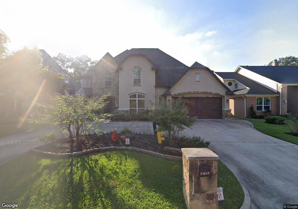
7907 Alamar Dr Houston, TX 77095
Hearthstone NeighborhoodEstimated Value: $593,000 - $839,464
5
Beds
6
Baths
4,431
Sq Ft
$162/Sq Ft
Est. Value
About This Home
This home is located at 7907 Alamar Dr, Houston, TX 77095 and is currently estimated at $718,366, approximately $162 per square foot. 7907 Alamar Dr is a home with nearby schools including Owens Elementary School, Labay Middle School, and Cypress Falls High School.
Ownership History
Date
Name
Owned For
Owner Type
Purchase Details
Closed on
Sep 26, 2014
Sold by
Starwood Homes Llc
Bought by
Mauvoisin Olivier Loic and Mauvoisin Eugene Jeanne
Current Estimated Value
Purchase Details
Closed on
May 30, 2013
Sold by
Bratten Developments Inc
Bought by
Starwood Homes Llc
Purchase Details
Closed on
Mar 25, 1994
Sold by
Looney Robert E and Looney Alice J
Bought by
Looney R Michael and Looney Susan M
Create a Home Valuation Report for This Property
The Home Valuation Report is an in-depth analysis detailing your home's value as well as a comparison with similar homes in the area
Home Values in the Area
Average Home Value in this Area
Purchase History
| Date | Buyer | Sale Price | Title Company |
|---|---|---|---|
| Mauvoisin Olivier Loic | -- | Frontier Title Co Wh Llc | |
| Starwood Homes Llc | -- | Stewart Title | |
| Looney R Michael | -- | -- |
Source: Public Records
Tax History Compared to Growth
Tax History
| Year | Tax Paid | Tax Assessment Tax Assessment Total Assessment is a certain percentage of the fair market value that is determined by local assessors to be the total taxable value of land and additions on the property. | Land | Improvement |
|---|---|---|---|---|
| 2025 | $13,227 | $725,702 | $106,122 | $619,580 |
| 2024 | $13,227 | $839,046 | $106,122 | $732,924 |
| 2023 | $13,227 | $789,644 | $106,122 | $683,522 |
| 2022 | $15,023 | $750,000 | $84,783 | $665,217 |
| 2021 | $14,333 | $642,889 | $84,783 | $558,106 |
| 2020 | $13,100 | $521,000 | $60,559 | $460,441 |
| 2019 | $13,523 | $521,000 | $67,155 | $453,845 |
| 2018 | $5,872 | $541,000 | $67,155 | $473,845 |
| 2017 | $15,587 | $598,063 | $67,155 | $530,908 |
| 2016 | $15,587 | $598,063 | $67,155 | $530,908 |
| 2015 | $1,620 | $567,571 | $67,155 | $500,416 |
| 2014 | $1,620 | $61,050 | $61,050 | $0 |
Source: Public Records
Map
Nearby Homes
- 7827 Alamar Dr
- 14931 Inverrary Dr
- 15131 New Hastings Dr
- 14919 Forest Trails Dr
- 14911 Sandalfoot St
- 15010 Chetland Place Dr
- 7637 Ameswood Rd
- 7731 Club Lake Dr
- 7418 Benwich Cir
- 7407 Bull Creek Rd
- 14823 Elmont Dr
- 8211 Riverglade Dr
- 8043 Oceanside Dr
- 14519 Sandalfoot St
- 7415 Broken Ridge Dr
- 15339 Glenwood Park Dr
- 14502 Sandalfoot St
- 14419 Verde Mar Ln
- 7411 Pacific Ridge Ct
- 14410 Muirfield Ln
- 7903 Alamar Dr
- 7911 Alamar Dr
- 14982 Sandalfoot St
- 7915 Alamar Dr
- 7835 Alamar Dr
- 14967 Royal Birkdale St
- 14978 Sandalfoot St
- 7919 Alamar Dr
- 7831 Alamar Dr
- 14963 Royal Birkdale St
- 14979 Sandalfoot St
- 14974 Sandalfoot St
- 7923 Alamar Dr
- 14959 Royal Birkdale St
- 14966 Royal Birkdale St
- 14975 Sandalfoot St
- 14970 Sandalfoot St
- 14955 Royal Birkdale St
- 14967 Sandalfoot St
- 15003 Inverrary Dr