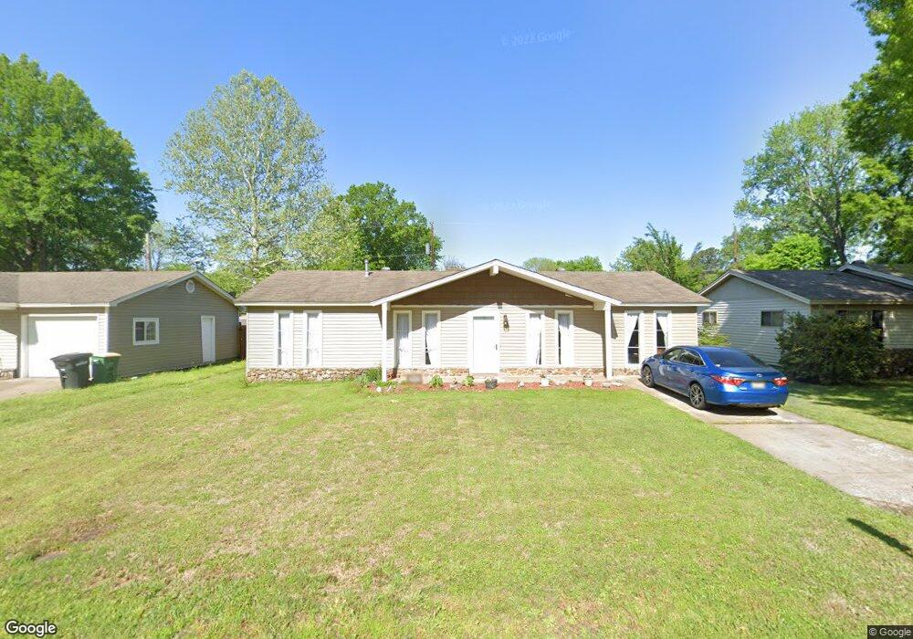
7911 Bronco Ln Sherwood, AR 72120
Estimated Value: $142,807 - $176,000
--
Bed
3
Baths
1,326
Sq Ft
$119/Sq Ft
Est. Value
About This Home
This home is located at 7911 Bronco Ln, Sherwood, AR 72120 and is currently estimated at $157,952, approximately $119 per square foot. 7911 Bronco Ln is a home located in Pulaski County with nearby schools including Sherwood Elementary School, Sylvan Hills Middle School, and Sylvan Hills High School.
Ownership History
Date
Name
Owned For
Owner Type
Purchase Details
Closed on
Nov 23, 2020
Sold by
Telcoe Federal Credit Union
Bought by
Sanders Clay T and Sanders Janise
Current Estimated Value
Home Financials for this Owner
Home Financials are based on the most recent Mortgage that was taken out on this home.
Original Mortgage
$89,800
Outstanding Balance
$79,909
Interest Rate
2.8%
Mortgage Type
New Conventional
Estimated Equity
$78,043
Purchase Details
Closed on
Jun 1, 2020
Sold by
Aldridge Poncy
Bought by
Telcoe Federal Credit Union
Purchase Details
Closed on
Aug 30, 2001
Sold by
Aldridge Scott
Bought by
Aldridge Poncy
Create a Home Valuation Report for This Property
The Home Valuation Report is an in-depth analysis detailing your home's value as well as a comparison with similar homes in the area
Home Values in the Area
Average Home Value in this Area
Purchase History
| Date | Buyer | Sale Price | Title Company |
|---|---|---|---|
| Sanders Clay T | $113,000 | Beach Abstract & Guaranty | |
| Telcoe Federal Credit Union | -- | None Available | |
| Aldridge Poncy | -- | -- |
Source: Public Records
Mortgage History
| Date | Status | Borrower | Loan Amount |
|---|---|---|---|
| Open | Sanders Clay T | $89,800 |
Source: Public Records
Tax History Compared to Growth
Tax History
| Year | Tax Paid | Tax Assessment Tax Assessment Total Assessment is a certain percentage of the fair market value that is determined by local assessors to be the total taxable value of land and additions on the property. | Land | Improvement |
|---|---|---|---|---|
| 2025 | $1,198 | $23,245 | $2,600 | $20,645 |
| 2024 | $1,027 | $23,245 | $2,600 | $20,645 |
| 2023 | $1,027 | $23,245 | $2,600 | $20,645 |
| 2022 | $1,079 | $23,245 | $2,600 | $20,645 |
| 2021 | $950 | $16,430 | $3,200 | $13,230 |
| 2020 | $575 | $16,430 | $3,200 | $13,230 |
| 2019 | $575 | $16,430 | $3,200 | $13,230 |
| 2018 | $585 | $16,430 | $3,200 | $13,230 |
| 2017 | $547 | $16,430 | $3,200 | $13,230 |
| 2016 | $509 | $14,680 | $3,200 | $11,480 |
| 2015 | $739 | $14,680 | $3,200 | $11,480 |
| 2014 | $739 | $14,549 | $3,200 | $11,349 |
Source: Public Records
Map
Nearby Homes
- 1804 Palomino Dr
- 1800 Palomino Dr
- 1415 Stafford Rd
- 1419 Stafford Rd
- 1423 Stafford Rd
- 1501 Stafford Rd
- 1926 E Lee Ave
- 8000 Pinto Trail
- +/- 21.56 Acres Stafford Rd
- 626 Newcastle Dr
- 1301 Stafford Rd
- +/- 8.16 Acres Windchime Ave
- 622 Newcastle Dr
- 1300 Stafford Rd
- 619 Newcastle Dr
- 618 & 620 Newcastle Dr
- 615 Brierly Dr
- 615 & 617 Brierly Dr
- 609 Newcastle Dr
- 105 Heatherbrae Ct
- 7915 Bronco Ln
- 7907 Bronco Ln
- 7906 Mustang Dr
- 7917 Bronco Ln
- 7905 Bronco Ln
- 7904 Mustang Dr
- 0 Bronco Ln
- 7914 Bronco Ln
- 7916 Bronco Ln
- 7908 Mustang Dr
- 0 Mustang Dr
- 7902 Mustang Dr
- 7918 Bronco Ln
- 7921 Bronco Ln
- 7901 Bronco Ln
- 7910 Bronco Ln
- 7910 Mustang Dr
- 7922 Bronco Ln
- 7900 Mustang Dr
- 7907 Mustang Dr