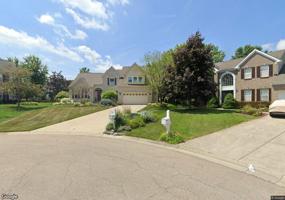
7911 South Trail Mason, OH 45040
Deerfield Township NeighborhoodEstimated Value: $599,000 - $696,000
4
Beds
3
Baths
2,958
Sq Ft
$214/Sq Ft
Est. Value
About This Home
This home is located at 7911 South Trail, Mason, OH 45040 and is currently estimated at $632,931, approximately $213 per square foot. 7911 South Trail is a home located in Warren County with nearby schools including Mason Intermediate Elementary School, Mason Middle School, and William Mason High School.
Ownership History
Date
Name
Owned For
Owner Type
Purchase Details
Closed on
Jan 13, 1999
Sold by
Williamsburg Properties
Bought by
Schuelke Marcus and Schuelke Kim M
Current Estimated Value
Home Financials for this Owner
Home Financials are based on the most recent Mortgage that was taken out on this home.
Original Mortgage
$195,000
Outstanding Balance
$45,346
Interest Rate
6.79%
Mortgage Type
New Conventional
Estimated Equity
$587,585
Purchase Details
Closed on
Sep 15, 1998
Sold by
Hunters Green Llc
Bought by
Williamsburg Properties Inc
Create a Home Valuation Report for This Property
The Home Valuation Report is an in-depth analysis detailing your home's value as well as a comparison with similar homes in the area
Home Values in the Area
Average Home Value in this Area
Purchase History
| Date | Buyer | Sale Price | Title Company |
|---|---|---|---|
| Schuelke Marcus | $244,445 | -- | |
| Williamsburg Properties Inc | $220,000 | -- |
Source: Public Records
Mortgage History
| Date | Status | Borrower | Loan Amount |
|---|---|---|---|
| Open | Schuelke Marcus | $195,000 |
Source: Public Records
Tax History Compared to Growth
Tax History
| Year | Tax Paid | Tax Assessment Tax Assessment Total Assessment is a certain percentage of the fair market value that is determined by local assessors to be the total taxable value of land and additions on the property. | Land | Improvement |
|---|---|---|---|---|
| 2024 | $7,491 | $173,890 | $38,500 | $135,390 |
| 2023 | $6,871 | $133,679 | $23,730 | $109,949 |
| 2022 | $6,871 | $133,679 | $23,730 | $109,949 |
| 2021 | $6,538 | $133,679 | $23,730 | $109,949 |
| 2020 | $6,810 | $118,300 | $21,000 | $97,300 |
| 2019 | $6,314 | $118,300 | $21,000 | $97,300 |
| 2018 | $6,247 | $118,300 | $21,000 | $97,300 |
| 2017 | $6,085 | $104,689 | $21,004 | $83,685 |
| 2016 | $6,253 | $104,689 | $21,004 | $83,685 |
| 2015 | $5,970 | $104,689 | $21,004 | $83,685 |
| 2014 | $5,970 | $93,470 | $18,750 | $74,720 |
| 2013 | $5,983 | $104,670 | $21,000 | $83,670 |
Source: Public Records
Map
Nearby Homes
- 7911 Meadowbrook Dr
- 6374 Hunters Green Dr
- 7839 Meadowbrook Dr
- 6439 Fox & Hound Ct
- 6482 Quail Lake
- 6589 Quail Lake
- 7679 Brookfarm Ct
- 8224 Summer View Dr
- 0 Castle Dr Unit 1837833
- 7725 Livingston Dr
- 6930 Walnut Meadows Dr
- 5754 Trailside Ct
- 7693 Misty Springs Ct
- 8606 Charleston Valley Dr
- 5661 Baywatch Way
- 8655 Charleston Creek Dr
- 7660 Waterfront Way
- 7648 Waterfront Way
- 7692 Waterfront Way
- 5626 Baywatch Way
- 7907 South Trail
- 7912 South Trail
- 7895 South Trail
- 7908 South Trail
- 7896 South Trail
- 6421 Edgewood Ct
- 6379 Greenfield Dr
- 7879 South Trail
- 6417 Edgewood Ct
- 7880 South Trail
- 6355 Greenfield Dr
- 6343 Greenfield Dr
- 7865 South Trail
- 6418 Edgewood Ct
- 7866 South Trail
- 6367 Greenfield Dr
- 7931 Meadowbrook Dr
- 7855 Hunt Club Dr
- 7843 Hunt Club Dr
- 7893 Meadowbrook Dr