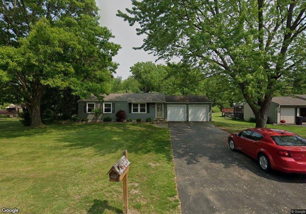
7913 Castle Rock Dr NE Warren, OH 44484
Estimated Value: $194,357 - $220,000
3
Beds
1
Bath
1,040
Sq Ft
$194/Sq Ft
Est. Value
About This Home
This home is located at 7913 Castle Rock Dr NE, Warren, OH 44484 and is currently estimated at $201,839, approximately $194 per square foot. 7913 Castle Rock Dr NE is a home located in Trumbull County with nearby schools including Howland High School and John F. Kennedy Catholic School - Lower Campus.
Ownership History
Date
Name
Owned For
Owner Type
Purchase Details
Closed on
Mar 10, 1999
Sold by
Schuring Linda T
Bought by
Gore Dennis A and Gore Gail M
Current Estimated Value
Home Financials for this Owner
Home Financials are based on the most recent Mortgage that was taken out on this home.
Original Mortgage
$81,344
Outstanding Balance
$19,737
Interest Rate
6.78%
Estimated Equity
$182,102
Purchase Details
Closed on
Jan 1, 1990
Bought by
Linda T Schuring
Create a Home Valuation Report for This Property
The Home Valuation Report is an in-depth analysis detailing your home's value as well as a comparison with similar homes in the area
Home Values in the Area
Average Home Value in this Area
Purchase History
| Date | Buyer | Sale Price | Title Company |
|---|---|---|---|
| Gore Dennis A | $81,500 | -- | |
| Linda T Schuring | -- | -- |
Source: Public Records
Mortgage History
| Date | Status | Borrower | Loan Amount |
|---|---|---|---|
| Open | Gore Dennis A | $81,344 |
Source: Public Records
Tax History Compared to Growth
Tax History
| Year | Tax Paid | Tax Assessment Tax Assessment Total Assessment is a certain percentage of the fair market value that is determined by local assessors to be the total taxable value of land and additions on the property. | Land | Improvement |
|---|---|---|---|---|
| 2024 | $2,484 | $46,970 | $7,700 | $39,270 |
| 2023 | $2,484 | $46,970 | $7,700 | $39,270 |
| 2022 | $2,288 | $36,400 | $7,000 | $29,400 |
| 2021 | $2,235 | $36,400 | $7,000 | $29,400 |
| 2020 | $2,244 | $36,400 | $7,000 | $29,400 |
| 2019 | $2,064 | $31,710 | $7,000 | $24,710 |
| 2018 | $1,975 | $31,710 | $7,000 | $24,710 |
| 2017 | $1,775 | $31,710 | $7,000 | $24,710 |
| 2016 | $1,629 | $28,280 | $7,000 | $21,280 |
| 2015 | $1,588 | $28,280 | $7,000 | $21,280 |
| 2014 | $1,533 | $28,280 | $7,000 | $21,280 |
| 2013 | $1,524 | $28,280 | $7,000 | $21,280 |
Source: Public Records
Map
Nearby Homes
- 7979 Brookwood St NE
- 7707 Raglan Dr NE
- 7751 Castle Rock Dr NE
- 7837 Raglan Dr NE
- 7697 Micawber Rd NE
- 0 King Graves Rd NE
- 108 Westwind Dr NE
- 8531 Red Oak Dr NE
- 8545 Carriage Hill Dr NE
- 4167 N River Rd NE
- 4260 N River Rd NE
- 106 N Aspen Ct Unit 4
- 8848 King Graves Rd NE
- 8936 Stetson Dr NE
- 610 Clifton Dr NE
- 741 Shady Ln NE
- 660 Rosegarden Dr NE
- 2133 Silver Fox Ln NE
- 0 Black Duck Ct Unit 5133669
- 0 Black Duck Ct Unit 5088418
- 7923 Castle Rock Dr NE
- 7903 Castle Rock Dr NE
- 7931 Castle Rock Dr NE
- 7901 Castle Rock Dr NE
- 7939 Castle Rock Dr NE
- 7798 Sutton Place NE
- 7910 Castle Rock Dr NE
- 7918 Castle Rock Dr NE
- 7949 Castle Rock Dr NE
- 7886 Castle Rock Dr NE
- 7788 Sutton Place NE
- 7928 Castle Rock Dr NE
- 7806 Sutton Place NE
- 7959 Castle Rock Dr NE
- 7874 Castle Rock Dr NE
- 7938 Castle Rock Dr NE
- 7899 Castle Rock Dr NE
- 7967 Castle Rock Dr NE
- 7772 Sutton Place NE
- 7822 Sutton Place NE