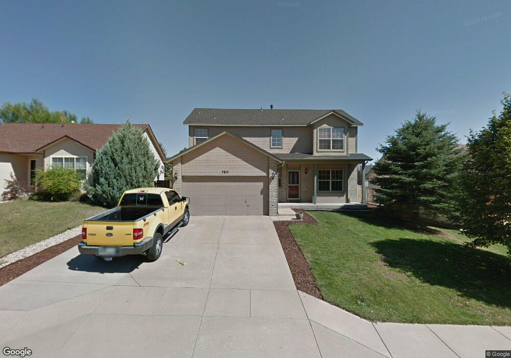
7915 Manston Dr Colorado Springs, CO 80920
Briargate NeighborhoodEstimated Value: $505,710 - $550,000
3
Beds
4
Baths
1,991
Sq Ft
$264/Sq Ft
Est. Value
About This Home
This home is located at 7915 Manston Dr, Colorado Springs, CO 80920 and is currently estimated at $524,678, approximately $263 per square foot. 7915 Manston Dr is a home located in El Paso County with nearby schools including Prairie Hills Elementary School, Timberview Middle School, and Liberty High School.
Ownership History
Date
Name
Owned For
Owner Type
Purchase Details
Closed on
May 31, 2006
Sold by
Howard Wayne M and Howard Lanesa D C
Bought by
Mercado Homero
Current Estimated Value
Home Financials for this Owner
Home Financials are based on the most recent Mortgage that was taken out on this home.
Original Mortgage
$254,014
Outstanding Balance
$144,525
Interest Rate
6%
Mortgage Type
VA
Estimated Equity
$380,153
Purchase Details
Closed on
Dec 19, 1997
Sold by
Hallmark Building Company Ltd I
Bought by
Howard Wayne M and Howard Lanesa D C
Home Financials for this Owner
Home Financials are based on the most recent Mortgage that was taken out on this home.
Original Mortgage
$169,040
Interest Rate
7.18%
Mortgage Type
VA
Create a Home Valuation Report for This Property
The Home Valuation Report is an in-depth analysis detailing your home's value as well as a comparison with similar homes in the area
Home Values in the Area
Average Home Value in this Area
Purchase History
| Date | Buyer | Sale Price | Title Company |
|---|---|---|---|
| Mercado Homero | $245,900 | Empire Title Co Springs Llc | |
| Howard Wayne M | $165,700 | Stewart Title |
Source: Public Records
Mortgage History
| Date | Status | Borrower | Loan Amount |
|---|---|---|---|
| Open | Mercado Homero | $254,014 | |
| Previous Owner | Howard Wayne M | $169,040 |
Source: Public Records
Tax History Compared to Growth
Tax History
| Year | Tax Paid | Tax Assessment Tax Assessment Total Assessment is a certain percentage of the fair market value that is determined by local assessors to be the total taxable value of land and additions on the property. | Land | Improvement |
|---|---|---|---|---|
| 2025 | $2,068 | $34,660 | -- | -- |
| 2024 | $2,029 | $35,970 | $5,360 | $30,610 |
| 2023 | $2,029 | $35,970 | $5,360 | $30,610 |
| 2022 | $1,723 | $24,420 | $4,340 | $20,080 |
| 2021 | $1,795 | $25,120 | $4,460 | $20,660 |
| 2020 | $1,769 | $22,980 | $3,720 | $19,260 |
| 2019 | $1,750 | $22,980 | $3,720 | $19,260 |
| 2018 | $1,506 | $19,430 | $2,880 | $16,550 |
| 2017 | $1,500 | $19,430 | $2,880 | $16,550 |
| 2016 | $1,504 | $19,460 | $2,930 | $16,530 |
| 2015 | $1,502 | $19,460 | $2,930 | $16,530 |
| 2014 | $1,379 | $17,860 | $2,930 | $14,930 |
Source: Public Records
Map
Nearby Homes
- 5109 Oyster Bay Dr
- 5026 Plumstead Dr
- 7820 Swiftrun Rd
- 7691 Scarborough Dr
- 5050 Plumstead Dr
- 7775 Manston Dr
- 7985 Interlaken Dr
- 7705 Chancellor Dr
- 8030 Chancellor Dr
- 7590 Chancellor Dr
- 5305 Plumstead Dr
- 8313 Scarborough Dr
- 8372 Wilmington Dr
- 8387 Snow Cap View
- Fairview Plan at Trailside at Cottonwood Creek
- Deerfield Plan at Trailside at Cottonwood Creek
- Ethridge Plan at Trailside at Cottonwood Creek
- Bryanwood Plan at Trailside at Cottonwood Creek
- Cherry Oak Plan at Trailside at Cottonwood Creek
- Alpine Plan at Trailside at Cottonwood Creek
- 7925 Manston Dr
- 7895 Manston Dr
- 7935 Manston Dr
- 7885 Manston Dr
- 7838 Potomac Dr
- 7834 Potomac Dr
- 7842 Potomac Dr
- 7830 Potomac Dr
- 7890 Manston Dr
- 7846 Potomac Dr
- 7910 Manston Dr
- 7875 Manston Dr
- 7945 Manston Dr
- 7880 Manston Dr
- 7826 Potomac Dr
- 7920 Manston Dr
- 7850 Potomac Dr
- 7870 Manston Dr
- 7930 Manston Dr
- 7865 Manston Dr