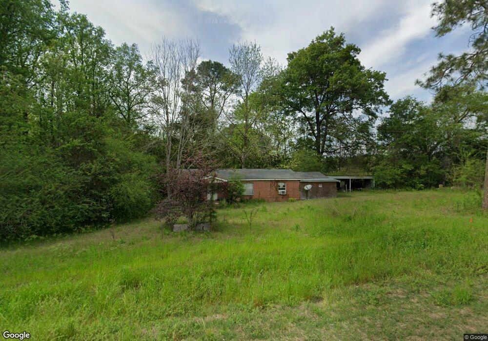
792 Ga Highway 270 W Doerun, GA 31744
Estimated Value: $136,503 - $194,000
3
Beds
1
Bath
1,452
Sq Ft
$117/Sq Ft
Est. Value
About This Home
This home is located at 792 Ga Highway 270 W, Doerun, GA 31744 and is currently estimated at $170,376, approximately $117 per square foot. 792 Ga Highway 270 W is a home located in Colquitt County with nearby schools including Doerun Elementary School, C.A. Gray Junior High School, and Willie J. Williams Middle School.
Ownership History
Date
Name
Owned For
Owner Type
Purchase Details
Closed on
Jun 13, 2016
Sold by
Us Bank National Associati
Bought by
Frederick Demetra S
Current Estimated Value
Purchase Details
Closed on
Nov 3, 2015
Sold by
Parker Maxie D
Bought by
Us Bank National Association T
Purchase Details
Closed on
Oct 3, 2014
Sold by
Schuyler Marion Josepgh
Bought by
Parker Maxie D
Purchase Details
Closed on
Mar 24, 2008
Sold by
Parker Maxie D
Bought by
Schuyler Marion
Purchase Details
Closed on
Apr 9, 2007
Sold by
Parker Bobby J
Bought by
Parker Maxie D
Purchase Details
Closed on
Jan 21, 2000
Bought by
Parker Maxie D Life Esta
Create a Home Valuation Report for This Property
The Home Valuation Report is an in-depth analysis detailing your home's value as well as a comparison with similar homes in the area
Home Values in the Area
Average Home Value in this Area
Purchase History
| Date | Buyer | Sale Price | Title Company |
|---|---|---|---|
| Frederick Demetra S | $13,000 | -- | |
| Us Bank National Association T | $39,563 | -- | |
| Parker Maxie D | -- | -- | |
| Schuyler Marion | $25,000 | -- | |
| Parker Maxie D | -- | -- | |
| Parker Maxie D | -- | -- | |
| Parker Maxie D | -- | -- | |
| Parker Maxie D | -- | -- | |
| Parker Maxie D Life Esta | $15,500 | -- |
Source: Public Records
Tax History Compared to Growth
Tax History
| Year | Tax Paid | Tax Assessment Tax Assessment Total Assessment is a certain percentage of the fair market value that is determined by local assessors to be the total taxable value of land and additions on the property. | Land | Improvement |
|---|---|---|---|---|
| 2024 | $924 | $39,061 | $5,053 | $34,008 |
| 2023 | $824 | $31,584 | $5,053 | $26,531 |
| 2022 | $672 | $28,207 | $4,492 | $23,715 |
| 2021 | $594 | $24,462 | $4,492 | $19,970 |
| 2020 | $569 | $23,042 | $4,492 | $18,550 |
| 2019 | $607 | $22,095 | $4,492 | $17,603 |
| 2018 | $565 | $22,095 | $4,492 | $17,603 |
| 2017 | $622 | $22,867 | $5,264 | $17,603 |
| 2016 | $634 | $22,988 | $5,264 | $17,724 |
| 2015 | $605 | $21,728 | $5,264 | $16,464 |
| 2014 | $539 | $21,728 | $5,264 | $16,464 |
| 2013 | -- | $21,727 | $5,263 | $16,464 |
Source: Public Records
Map
Nearby Homes
- 511 W Broad Ave
- 417 W Bay Ave
- 104 Union Ln
- 318 E Culpepper Ave
- 712 Blackberry Rd
- 512 Hagin Still Rd
- 0 Brest Station Rd Unit 10642758
- 156 E Maple St
- 155 N Kreuger St
- 4409 Georgia 112
- 1485 Bay Rd
- 9765 Morey Hill Rd
- 340 Bryan Rd
- 340 Belk Rd
- 9953 Gravel Hill Rd
- 201 Worthwood Rd
- 202 Oak Grove Dr
- 0 Pleasant Grove Church Rd
- 378 Old S R 33
- 00 Rossman Dairy Rd