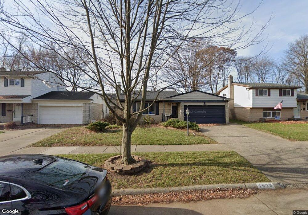
7929 Kaiser St Canton, MI 48187
Estimated Value: $278,245 - $324,000
3
Beds
2
Baths
1,045
Sq Ft
$285/Sq Ft
Est. Value
About This Home
This home is located at 7929 Kaiser St, Canton, MI 48187 and is currently estimated at $298,311, approximately $285 per square foot. 7929 Kaiser St is a home located in Wayne County with nearby schools including Canton High School, East Middle School, and Salem High School.
Ownership History
Date
Name
Owned For
Owner Type
Purchase Details
Closed on
Jun 25, 2008
Sold by
Abajian Suzan
Bought by
Brennan Catherine M
Current Estimated Value
Purchase Details
Closed on
Feb 7, 2000
Sold by
Majoor Cherie
Bought by
Abajian Susan
Purchase Details
Closed on
May 18, 1994
Sold by
Mills James D
Bought by
Mills James D
Home Financials for this Owner
Home Financials are based on the most recent Mortgage that was taken out on this home.
Original Mortgage
$91,650
Interest Rate
8.48%
Mortgage Type
New Conventional
Create a Home Valuation Report for This Property
The Home Valuation Report is an in-depth analysis detailing your home's value as well as a comparison with similar homes in the area
Home Values in the Area
Average Home Value in this Area
Purchase History
| Date | Buyer | Sale Price | Title Company |
|---|---|---|---|
| Brennan Catherine M | $150,000 | None Available | |
| Abajian Susan | $149,000 | -- | |
| Mills James D | $96,500 | -- |
Source: Public Records
Mortgage History
| Date | Status | Borrower | Loan Amount |
|---|---|---|---|
| Previous Owner | Mills James D | $91,650 |
Source: Public Records
Tax History
| Year | Tax Paid | Tax Assessment Tax Assessment Total Assessment is a certain percentage of the fair market value that is determined by local assessors to be the total taxable value of land and additions on the property. | Land | Improvement |
|---|---|---|---|---|
| 2025 | $1,191 | $123,000 | $0 | $0 |
| 2024 | $1,157 | $111,800 | $0 | $0 |
| 2023 | $1,103 | $100,100 | $0 | $0 |
| 2022 | $2,495 | $90,600 | $0 | $0 |
| 2021 | $2,420 | $83,900 | $0 | $0 |
| 2020 | $2,390 | $82,000 | $0 | $0 |
| 2019 | $2,347 | $71,780 | $0 | $0 |
| 2018 | $938 | $69,400 | $0 | $0 |
| 2017 | $2,461 | $66,800 | $0 | $0 |
| 2016 | $2,141 | $64,100 | $0 | $0 |
| 2015 | $5,152 | $57,180 | $0 | $0 |
| 2013 | $5,007 | $52,060 | $0 | $0 |
| 2010 | -- | $57,000 | $28,888 | $28,112 |
Source: Public Records
Map
Nearby Homes
- 39857 Edmundton St
- 00 Commerce Blvd
- 000 Commerce Blvd
- 39618 Bart St
- 219 W Fern
- 39500 Warren Rd Unit 242
- 39500 Warren Rd Unit 144
- 39500 Warren Rd Unit 154
- 39500 Warren Rd Unit 115
- 39500 Warren Rd Unit 174
- 39500 Warren Rd Unit 208
- 40504 Newport Dr
- 40584 Newport Ct
- 40548 Newport Dr
- 41430 Warren Rd
- 38508 Alma Ln
- 41415 Copper Creek Dr Unit 17
- 8821 Knolson Ave
- 8895 Knolson Ave
- 38360 Overbrook Ln
- 7917 Kaiser St
- 7941 Kaiser St
- 7905 Kaiser St
- 7953 Kaiser St
- 7879 Kaiser St
- 7965 Kaiser St
- 7928 Kaiser St
- 7914 Kaiser St
- 7950 Kaiser St
- 7865 Kaiser St
- 7977 Kaiser St
- 39975 Hillary Dr
- 7851 Kaiser St
- 7860 Kaiser St
- 39926 Edmunton St
- 7989 Kaiser St
- 39951 Hillary Dr
- 7837 Kaiser St
- 7842 Kaiser St
- 39912 Edmundton Dr
Your Personal Tour Guide
Ask me questions while you tour the home.