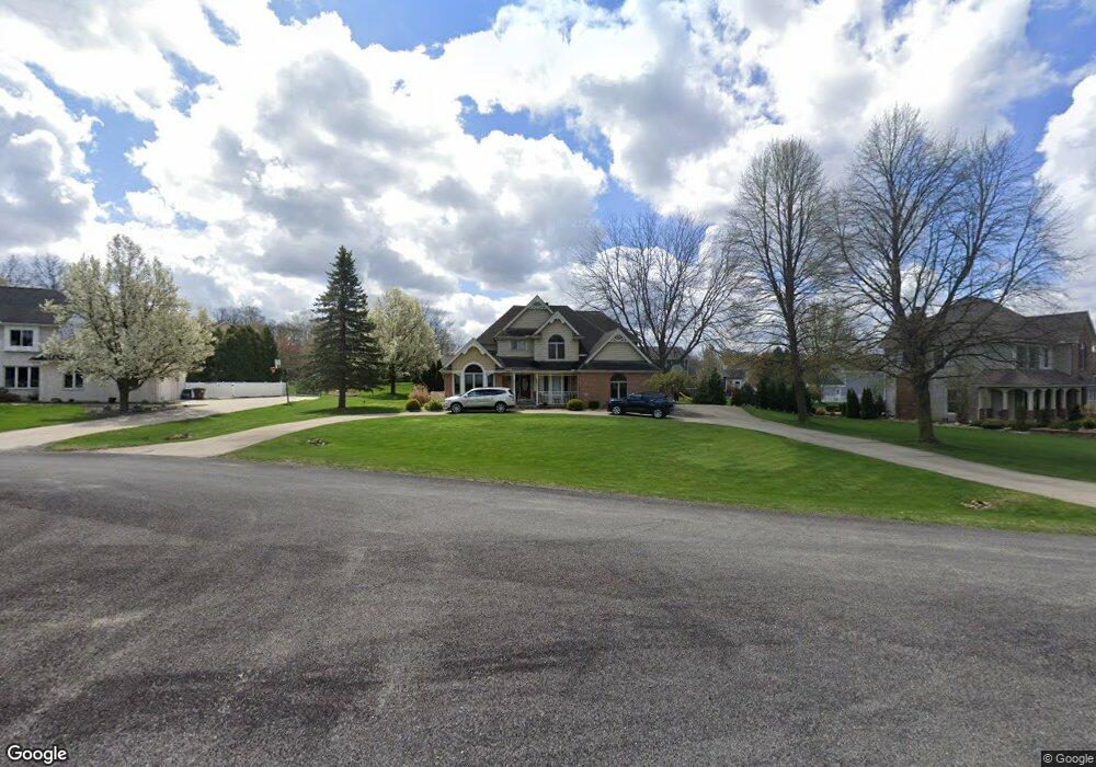
7933 St Andrews Dr Tecumseh, MI 49286
Estimated Value: $461,158 - $504,000
4
Beds
3
Baths
2,800
Sq Ft
$170/Sq Ft
Est. Value
About This Home
This home is located at 7933 St Andrews Dr, Tecumseh, MI 49286 and is currently estimated at $474,790, approximately $169 per square foot. 7933 St Andrews Dr is a home located in Lenawee County with nearby schools including Tecumseh Middle School, Herrick Park Intermediate Learning Center, and Tecumseh High School.
Ownership History
Date
Name
Owned For
Owner Type
Purchase Details
Closed on
Nov 9, 2016
Sold by
Montgomery Monica and Montgomery Michael C
Bought by
Montgomery Monica and Montgomery Michael C
Current Estimated Value
Home Financials for this Owner
Home Financials are based on the most recent Mortgage that was taken out on this home.
Original Mortgage
$237,475
Outstanding Balance
$190,951
Interest Rate
3.47%
Mortgage Type
New Conventional
Estimated Equity
$283,839
Purchase Details
Closed on
Apr 28, 2016
Sold by
Mortgage Electronic Registration Systems
Bought by
Liberty Savings Bank Fsb
Purchase Details
Closed on
Mar 17, 2004
Bought by
Davis Michael J and Davis Leann R
Create a Home Valuation Report for This Property
The Home Valuation Report is an in-depth analysis detailing your home's value as well as a comparison with similar homes in the area
Home Values in the Area
Average Home Value in this Area
Purchase History
| Date | Buyer | Sale Price | Title Company |
|---|---|---|---|
| Montgomery Monica | -- | Attorney | |
| Montgomery Michael C | $250,000 | Attorney | |
| Liberty Savings Bank Fsb | $212,279 | None Available | |
| Davis Michael J | $317,500 | -- |
Source: Public Records
Mortgage History
| Date | Status | Borrower | Loan Amount |
|---|---|---|---|
| Open | Montgomery Michael C | $237,475 |
Source: Public Records
Tax History Compared to Growth
Tax History
| Year | Tax Paid | Tax Assessment Tax Assessment Total Assessment is a certain percentage of the fair market value that is determined by local assessors to be the total taxable value of land and additions on the property. | Land | Improvement |
|---|---|---|---|---|
| 2025 | $7,151 | $239,600 | $0 | $0 |
| 2024 | $5,995 | $220,100 | $0 | $0 |
| 2022 | $6,007 | $189,300 | $0 | $0 |
| 2021 | $7,018 | $188,800 | $0 | $0 |
| 2020 | $6,922 | $190,000 | $0 | $0 |
| 2019 | $355,233 | $138,800 | $0 | $0 |
| 2018 | $6,616 | $152,694 | $0 | $0 |
| 2017 | $6,429 | $238,757 | $0 | $0 |
| 2016 | $3,236 | $237,394 | $0 | $0 |
| 2014 | -- | $227,191 | $0 | $0 |
Source: Public Records
Map
Nearby Homes
- 799 War Bonnet Dr
- 797 War Bonnet Dr
- 796 War Bonnet Dr
- 510 E Logan St
- 1018 Ridgeview Dr
- 6 Wheatland Dr
- 800 Stetson St
- 416 E Logan St
- 395 Burt St
- 1015 Preservation Dr
- Parcel B Fieldstone Dr
- 408 E Logan St
- 102 N Maumee St
- 209 Burt St
- 607 Shadow Brooke Ln
- 7484 Billmyer Hwy
- 215 S Oneida St
- 210 S Ottawa St
- 700 E Russell Rd
- 301 W Shawnee St
- 7933 Saint Andrews Dr
- 7961 Saint Andrews Dr
- 7961 Saint Andrews Dr Unit BLK
- 7907 Saint Andrews Dr
- 2 St Andrews Dr
- 7906 Saint Andrews Dr
- 7924 Saint Andrews Dr
- 7942 Saint Andrews Dr
- 5154 Turnberry Ct
- 7881 Saint Andrews Dr
- 7881 Saint Andrews Dr Unit SAINT ANDREWS
- 7881 St Andrews Dr
- 7960 Saint Andrews Dr
- 7978 Saint Andrews Dr
- 7852 Saint Andrews Dr
- 7834 St Andrews Dr
- 7834 Saint Andrews Dr
- 5190 Turnberry Ct
- 7835 Saint Andrews Dr
- 7798 Saint Andrews Dr