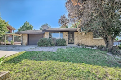
7936 Marshall Cir Arvada, CO 80003
Parkway Estates NeighborhoodEstimated payment $3,362/month
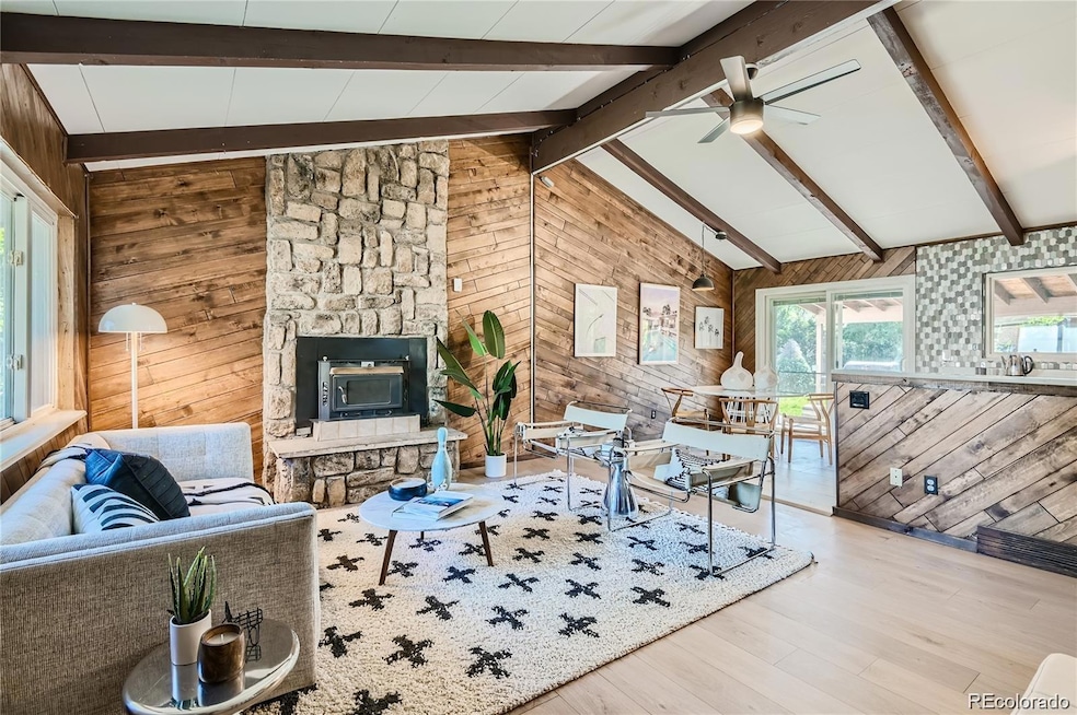
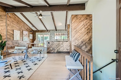
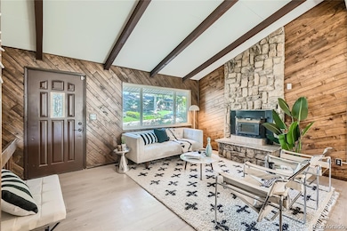
Highlights
- Vaulted Ceiling
- No HOA
- Tile Flooring
- 1 Fireplace
- 1 Car Attached Garage
- 1-Story Property
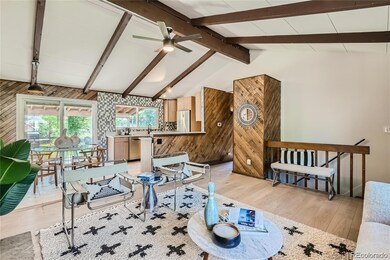
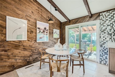
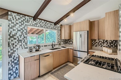
About This Home
Beautifully updated mid-century modern home in the Arvada Parkway Estates neighborhood. This home has been freshly renovated with new paint, fixtures and flooring throughout. This home immediately greets you with a mid-mod feel with its gorgeous vaulted ceilings and wonderful layout. The stunning open kitchen has ample counter space and cabinets for storage. Home has a large backyard with storage shed, as well as oversized 1 car garage and carport for ample parking. This home is also located in a wonderful, quiet neighborhood with plenty of places to take your pups on some long walks - including to Lake Arbor! Conveniently located near 80th and Wadsworth for an easy commute. Check out this beauty today! PROPERTY IS TENANT OCCUPIED UNTIL MARCH 31, 2026. Rents for $3,000/month.
Listing Agent
MAGGIE WEBB Brokerage Email: maggie@wgacolorado.com,719-217-7662 License #100089915 Listed on: 10/23/2025
Home Details
Home Type
- Single Family
Est. Annual Taxes
- $3,697
Year Built
- Built in 1970 | Remodeled
Lot Details
- 9,583 Sq Ft Lot
- Property is Fully Fenced
- Sloped Lot
Parking
- 1 Car Attached Garage
- 1 Carport Space
Home Design
- Brick Exterior Construction
- Composition Roof
Interior Spaces
- 1-Story Property
- Vaulted Ceiling
- 1 Fireplace
- Finished Basement
- 1 Bedroom in Basement
Kitchen
- Oven
- Range
- Dishwasher
- Disposal
Flooring
- Carpet
- Tile
- Vinyl
Bedrooms and Bathrooms
- 3 Bedrooms | 2 Main Level Bedrooms
- 2 Full Bathrooms
Laundry
- Dryer
- Washer
Schools
- Jefferson Academy Charter Elementary School
- North Arvada Middle School
- Arvada High School
Utilities
- Forced Air Heating and Cooling System
Community Details
- No Home Owners Association
- Parkway Estates Subdivision
Listing and Financial Details
- Exclusions: Tenants and sellers personal property, planter boxes in backyard
- Assessor Parcel Number 081689
Map
Home Values in the Area
Average Home Value in this Area
Tax History
| Year | Tax Paid | Tax Assessment Tax Assessment Total Assessment is a certain percentage of the fair market value that is determined by local assessors to be the total taxable value of land and additions on the property. | Land | Improvement |
|---|---|---|---|---|
| 2024 | $2,721 | $28,055 | $9,975 | $18,080 |
| 2023 | $2,721 | $28,055 | $9,975 | $18,080 |
| 2022 | $2,386 | $24,366 | $8,624 | $15,742 |
| 2021 | $1,734 | $25,067 | $8,872 | $16,195 |
| 2020 | $1,584 | $23,565 | $8,555 | $15,010 |
| 2019 | $1,563 | $23,565 | $8,555 | $15,010 |
| 2018 | $1,303 | $20,509 | $6,534 | $13,975 |
| 2017 | $1,193 | $20,509 | $6,534 | $13,975 |
| 2016 | $943 | $17,874 | $5,910 | $11,964 |
| 2015 | $725 | $17,874 | $5,910 | $11,964 |
| 2014 | $725 | $14,317 | $5,895 | $8,422 |
Property History
| Date | Event | Price | List to Sale | Price per Sq Ft |
|---|---|---|---|---|
| 10/23/2025 10/23/25 | For Sale | $580,000 | -- | $628 / Sq Ft |
Purchase History
| Date | Type | Sale Price | Title Company |
|---|---|---|---|
| Special Warranty Deed | $480,000 | First American Title | |
| Warranty Deed | $303,500 | None Available |
Source: REcolorado®
MLS Number: 8416691
APN: 29-362-04-037
Disclaimer: Certain information contained herein is derived from information provided by parties other than Homes.com. All information provided is deemed reliable, but is not guaranteed to be accurate and should be independently verified.
![]() The content relating to real estate for sale in this Web site comes in part from the Internet Data eXchange (“IDX”) program of METROLIST, INC., DBA RECOLORADO®. Real estate listings held by brokers other than Ten-X are marked with the IDX Logo. This information is being provided for the consumers’ personal, non-commercial use and may not be used for any other purpose. All information subject to change and should be independently verified.
The content relating to real estate for sale in this Web site comes in part from the Internet Data eXchange (“IDX”) program of METROLIST, INC., DBA RECOLORADO®. Real estate listings held by brokers other than Ten-X are marked with the IDX Logo. This information is being provided for the consumers’ personal, non-commercial use and may not be used for any other purpose. All information subject to change and should be independently verified.
This publication is designed to provide information with regard to the subject matter covered. It is displayed with the understanding that the publisher and authors are not engaged in rendering real estate, legal, accounting, tax, or other professional services and that the publisher and authors are not offering such advice in this publication. If real estate, legal, or other expert assistance is required, the services of a competent, professional person should be sought.
The information contained in this publication is subject to change without notice. METROLIST, INC., DBA RECOLORADO MAKES NO WARRANTY OF ANY KIND WITH REGARD TO THIS MATERIAL, INCLUDING, BUT NOT LIMITED TO, THE IMPLIED WARRANTIES OF MERCHANTABILITY AND FITNESS FOR A PARTICULAR PURPOSE. METROLIST, INC., DBA RECOLORADO SHALL NOT BE LIABLE FOR ERRORS CONTAINED HEREIN OR FOR ANY DAMAGES IN CONNECTION WITH THE FURNISHING, PERFORMANCE, OR USE OF THIS MATERIAL.
PUBLISHER’S NOTICE: All real estate advertised herein is subject to the Federal Fair Housing Act and the Colorado Fair Housing Act, which Acts make it illegal to make or publish any advertisement that indicates any preference, limitation, or discrimination based on race, color, religion, sex, handicap, familial status, or national origin.
METROLIST, INC., DBA RECOLORADO will not knowingly accept any advertising for real estate that is in violation of the law. All persons are hereby informed that all dwellings advertised are available on an equal opportunity basis.
© 2025 METROLIST, INC., DBA RECOLORADO® – All Rights Reserved. 6455 S. Yosemite St., Suite 500 Greenwood Village, CO 80111 USA
ALL RIGHTS RESERVED WORLDWIDE. No part of this publication may be reproduced, adapted, translated, stored in a retrieval system or transmitted in any form or by any means, electronic, mechanical, photocopying, recording, or otherwise, without the prior written permission of the publisher. The information contained herein including but not limited to all text, photographs, digital images, virtual tours, may be seeded and monitored for protection and tracking.
- 6431 W 77th Place
- 6419 W 77th Ave
- 7630 Pierce St
- 6161 W 77th Place
- 7958 Harlan St
- 6820 W 80th Cir
- 6413 W 76th Ave
- 8220 Lamar Cir
- 5790 W 79th Ave
- 5803 Pomona Dr
- 8221 Marshall Ct
- 6972 W 76th Ave
- 7812 Webster Way
- 5690 W 79th Ave
- 5690 W 80th Place Unit 98
- 7042 W 76th Ave
- 7495 Kendall St
- 5620 W 80th Place Unit 67
- 7516 Quay St
- 6233 W 75th Ave
- 8205 Ingalls Cir
- 7515 Otis St Unit 7515 Otis Street
- 5620 W 80th Place Unit 53
- 7944 Chase Cir Unit 116
- 7971 Chase Cir
- 7421 Harlan Way
- 6785 W 84th Way
- 5320 W 80th Ave
- 5301 W 76th Ave Unit 127
- 6925 W 84th Way
- 6119 W 85th Place
- 8055 Wolff St Unit E
- 4941 W 81st Place
- 8200 Sheridan Blvd
- 7569 W 72nd Ave
- 8773 Chase Dr
- 8023 Wolff St
- 7865 Allison Way
- 8772 Chase Dr
- 8300 Sheridan Blvd
