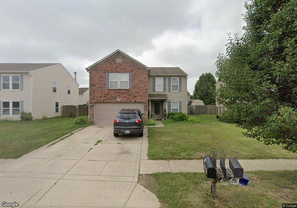
795 Country Gate Dr Whiteland, IN 46184
Estimated Value: $278,792 - $332,000
4
Beds
3
Baths
1,992
Sq Ft
$147/Sq Ft
Est. Value
About This Home
This home is located at 795 Country Gate Dr, Whiteland, IN 46184 and is currently estimated at $293,698, approximately $147 per square foot. 795 Country Gate Dr is a home located in Johnson County with nearby schools including Break-O-Day Elementary School, Clark-Pleasant Middle School, and Whiteland Community High School.
Ownership History
Date
Name
Owned For
Owner Type
Purchase Details
Closed on
Jun 16, 2010
Sold by
Gordon John B and Gordon Amanda K
Bought by
Chism Steven L
Current Estimated Value
Home Financials for this Owner
Home Financials are based on the most recent Mortgage that was taken out on this home.
Original Mortgage
$88,804
Outstanding Balance
$60,672
Interest Rate
5.37%
Mortgage Type
FHA
Estimated Equity
$233,026
Create a Home Valuation Report for This Property
The Home Valuation Report is an in-depth analysis detailing your home's value as well as a comparison with similar homes in the area
Home Values in the Area
Average Home Value in this Area
Purchase History
| Date | Buyer | Sale Price | Title Company |
|---|---|---|---|
| Chism Steven L | -- | First American Title Insuran |
Source: Public Records
Mortgage History
| Date | Status | Borrower | Loan Amount |
|---|---|---|---|
| Open | Chism Steven L | $88,804 |
Source: Public Records
Tax History Compared to Growth
Tax History
| Year | Tax Paid | Tax Assessment Tax Assessment Total Assessment is a certain percentage of the fair market value that is determined by local assessors to be the total taxable value of land and additions on the property. | Land | Improvement |
|---|---|---|---|---|
| 2025 | $2,398 | $237,500 | $56,000 | $181,500 |
| 2024 | $2,398 | $229,700 | $56,000 | $173,700 |
| 2023 | $2,370 | $227,200 | $56,000 | $171,200 |
| 2022 | $2,016 | $194,800 | $29,900 | $164,900 |
| 2021 | $1,726 | $166,600 | $29,900 | $136,700 |
| 2020 | $1,531 | $147,300 | $29,900 | $117,400 |
| 2019 | $1,463 | $140,900 | $29,900 | $111,000 |
| 2018 | $1,326 | $133,600 | $15,700 | $117,900 |
| 2017 | $1,252 | $124,300 | $15,700 | $108,600 |
| 2016 | $1,243 | $123,300 | $15,700 | $107,600 |
| 2014 | $1,196 | $118,600 | $19,100 | $99,500 |
| 2013 | $1,196 | $119,300 | $19,100 | $100,200 |
Source: Public Records
Map
Nearby Homes
- 780 Wheat Field Ln
- 638 Harvest Meadow Way
- 1041 Mount Olive Rd
- 551 Greenwood Trace Dr
- 53 Oakden Ct
- 57 Oakden Ct
- 39 Meadow Creek Blvd E
- 172 Country Wood Dr
- 49 Meadow Creek Blvd E
- 101 Grassyway Ct
- 50 Meadow Creek Blvd
- 528 Genisis Dr
- 1037 Warwick Rd
- 1108 Warwick Dr
- 6540 N Us Highway 31
- 124 Meadow Creek Dr S
- 847 Willark Dr
- 924 Norfolk Ln
- 915 Norfolk Ln
- Ironwood Plan at Lincoln Place
- 805 Country Gate Dr
- 786 Hickory Pine Dr
- 775 Country Gate Dr
- 806 Hickory Pine Dr
- 815 Country Gate Dr
- 776 Hickory Pine Dr
- 794 Country Gate Dr
- 784 Country Gate Dr
- 804 Country Gate Dr
- 765 Country Gate Dr
- 766 Hickory Pine Dr
- 816 Hickory Pine Dr
- 774 Country Gate Dr
- 756 Hickory Pine Dr
- 755 Country Gate Dr
- 764 Country Gate Dr
- 861 Wheat Field Ln
- 787 Hickory Pine Dr
- 777 Hickory Pine Dr
- 797 Hickory Pine Dr